St. Bartholomew's Church is a beautiful brick church, that is located right on the Yellowstone Trail on higway M, just west of Mill Creek. The church was built in 1883, and the cache is located on the edge of the cemetary behind the church. The cache is not near any tombstone.
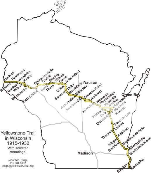
This is one of several caches I have placed along the route of the historic Yellowstone Trail. The trail is a historic motor route that went across Wisconsin from 1918 to 1930. The Wisconsin portion of the Yellowstone Trail is 406 miles long, starting at the state line south of Kenosha and going north, and then west to Hudson. The Wisconsin segment is just a part of one of America’s first transcontinental auto routes, a 3,754-mile long road that started in Plymouth Rock, Massachusetts and went to Puget Sound, Washington.
Before there were numbered highways in the United States there were names attached to roads to help motorists navigate from town to town or from county to county. Hailed as being “A Good Road from Plymouth Rock to Puget Sound,” the Yellowstone Trail began as a 25-mile stretch of road near Ipswitch, South Dakota.
In October 1912, Mr. J. W. Parmley formed the Yellowstone Trail Association. By 1917 the Yellowstone Trail had grown to become the main auto route for those travelling from the East Coast to Yellowstone National Park and the Pacific Northwest. While the Association did not build roads, it did lobby local governments in towns along the Trail to help promote the fledgling automobile tourism industry by building and maintaining “good roads.” Trail towns paid the Association a small fee or “assessment” to help cover advertising expenses and upkeep of the Trail.
For the most scenic route follow the route of the old Yellowstone trail, going west continue down highway M to Maple Street. Go north on Maple to Woods. Go west on Woods to N. Elm, and go north on N. Elm into Junction City. This route is very scenic. Reportedly, there was once a large town between Mill Creek and Junction, known as Carson, but I can see no evidence of that town, other than the fact the township is called Carson.
The posted coordinates will take you to the stone of a WWI veteran, Frank Niemczyk. To find the final cache, get some information off of his stone related to his military career, and the final cache, is not far away.
The final is at:
44.32.AAA
89.40.BBB
AAA equals 413 - the Company number he served in.
BBB equals 742 + the Depot number he served in.
As this is classified as a cemetery cache please note it is NOT hidden on any grave marker or site. If there is a service going on, or folks are visiting their loved ones when you arrive please be respectful and come back at a later time. Your understanding and compassion for those folks will be appreciated.