Important things to know to avoid log deletion:
- if your answers will be sent at a later time, state when I will receive them in your found log.
- required photo must be personalized in some way so that I know you were truly there.
If I delete your found log due to lack of following instructions, you can re-log your find when you are able to comply.
In order to log this earthcache:
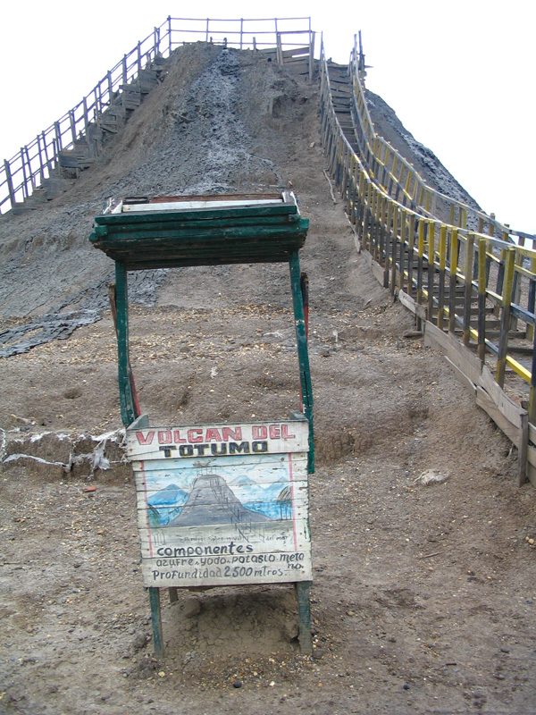
1. Visit the mud volcano at the given coordinates.
2. Download a personalized photo of yourself and your GPS at the base of the volcano. Each person logging a find must post their own photo. Do this at the same time that you post your log.
3. Send answers to the following questions in a separate e-mail directly to me at the same time that you post your log. Please do not put the answers in your log.
- estimate the temperature of the mud on the day you visit.
- what is the elevation on your GPS at the base of the volcano.
- estimate the elevation at the top of the volcano.
4. “Extra credit” post a photo of yourself in the mud.
Taking a mud bath:
Upon arrival, you change into your swim suit or trunks, ascend the steps to the top of the volcano, climb down a little wooden ladder and then immerse yourself in a pool of mud the consistency of chocolate cream. Before getting muddy, you can give your camera to one of the locals who manage having 15 or more cameras strapped on their arms and then remember which camera belongs to whom when snapping pictures.
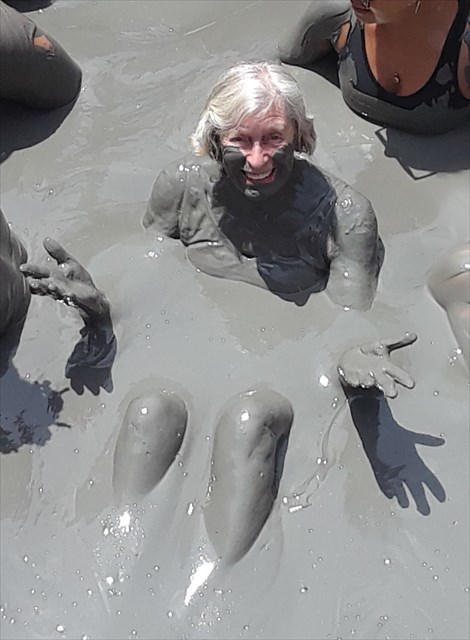
The depth of the “hole” is about 60’, yet you are so buoyant that you float on top with ease. When you’ve had your fill of mud immersion, walk to the lagoon a few yards away where local women will lead you out into the shallows, sit you down, and bathe the mud off of you.
It’s a once-in-a-lifetime experience that I completely enjoyed! (There is no cost unless you decide to take a mud bath; if you do, the costs are minimal for tips to the locals.
WHAT ARE MUD VOLCANOES?
At several points near the Caribbean coast between the Gulf of Uraba and Santa Marta there are strange “mud volcanoes” where warm flows of black, grey or brown mud rise to the surface forming small lakes or pools. Sometimes a ridge builds up around the feature to form a cone that can be 20 meters or more above the surrounding area. One of the best examples is the Volcan de Totuma at Galerazamba between Barranquilla and Cartagena. Elsewhere there may only be fissures in the ground with occasional activity and emissions of sulfurous gases, whereas Volcan de Totuma is well defined and continuously active.
The cause of these mud volcanoes is controversial. Most of them are associated with underground petroleum oil and gas deposits, where volatile gases combine with water shales and mudstones and ooze to the surface. Many are found under the sea and have been an important help in the search for marine oilfields, such as in the Gulf of Mexico. Some recent explorations have been in the Caribbean near the coast of Panama, northwest of Columbia.
The coast in the area of Vocan de Totuma in Columbia represents the border between the South American and the Caribbean tectonic plates that are slowly moving against each other at about 1-2 centimeters a year. A few kilometers inland there is an active line of instability, parallel to the coastline, known as the Sinu-San Jacinto fold belt, which is also the origin of the low hills from Uraba northeast to Barranquilla.
Geologists generally believe that this is the origin of the mud volcanoes. The heat generated by the movement between the plates, along with the gases released, move up through the soft, sedimentary layers many kilometers thick and bubble to the surface. These sediments have been built up by the major rivers that have been flowing northward for millions of years and may be additionally penetrated by seawater from the ocean. This process could also explain the happy absence of large interplate thrust earthquakes in this region.
For additional information, you may do research on diapirism (related to the buoyancy found in the volcano) and piercement structures.