Toteis-See / kettle hole "Fauler See" EarthCache
Toteis-See / kettle hole "Fauler See"
-
Difficulty:
-

-
Terrain:
-
Size:  (not chosen)
Please note Use of geocaching.com services is subject to the terms and conditions
in our disclaimer.
(English description below)
Dieser Earth Cache führt euch zum Faulen See in Weißensee (OT), im Berliner Bezirk Pankow. Dieses Gebiet ist seit 1933 ein offizielles Naturschutzgebiet und gleichzeitig Volkspark, und hat eine Größe von etwa 24 Hektar, wobei der See 5 Hektar groß ist.
Der See ist ein Toteissee, also ein See, der durch das Abschmelzen von Toteisblöcken, Eisblöcken, die von einem Gletscher losgelöst sind, und daher nicht mehr bewegt werden, entstanden ist. Dabei sackt das darüber liegende Sediment mit ab, und durch das Schmelzwasser füllt sich das entstandene Loch mit Wasser. Oft haben Toteisseen daher keine Zuflüsse. Die Form, Größe und Tiefe von Toteisseen können sehr unterschiedlich sein.
An N 52 33.252 E 13 29.399
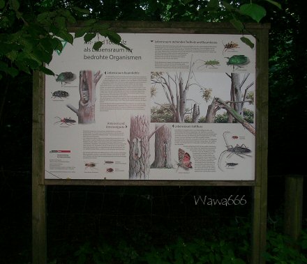
findet ihr genau vor euch eine Infotafel mit der Aufschrift "Alt- und Todholz als Lebensraum für bedrohte Organismen". Dies ist die Fotostelle! Macht hier ein Foto von euch (oder eurem GPS) mit dieser Tafel im Hintergrund. Bitte nicht vor den anderen Tafeln fotografieren, denn die brauchen wir noch für die Fragen, die zu diesem Cache beantwortet werden müssen.
Die Lösungen bitte über mein Profil an mich schicken und loggen Überprüfe die Antworten dazu und meld mich ggf. wenn was falsch war bei euch!
1. Welches Material lagerte sich meist auf Toteisblöcken ab? (Material der Sedimente)
2. Durch welche Eiszeit wurde die Landschaft in Berlin und Brandenburg geprägt?
3. Nenne drei Insektenarten, deren Name aus mindestens drei Teilen besteht, die im Naturschutzgebiet Fauler See leben. Die Hinweistafeln sind dabei hilfreich.
4. Nenne eine Fledermausart, die im Naturschutzgebiet Fauler See lebt.
Viel Erfolg!
Wawa666
-----------------------------------
ENGLISH DESCRIPTION
This Earth Cache is located at the "Fauler See" (foul lake) in Weissensee, in Berlin's district Pankow. The "Fauler See" is an official nature reserve since 1933, and an urban park at the same time, measuring 24 hectares; the lake itself measures 5 hectares.
The lake is a kettle hole of dead ice, which means ice blocks separated from the glacier, which aren't transported further. When these dead ice blocks melt, the sediment above the ice block sinks down, forming a hole in the ground, which gets filled with melting water, and thus is turned into a lake. Therefore, dead ice kettle holes often aren't connected to any streams. The shape, depth and size of kettle holes vary.
At the coordinates N 52 33.252 E 13 29.399
you are standing in front of some information panels. Right before you there is one with the headline "Alt- und Todholz als Lebensraum für bedrohte Organismen" (old and dead wood as a habitat for endangered organisms). This is the photo point - please take a photo of yourself (or your GPS) with this information panel in the background. Please don't take the picture with any of the other information panels visible, because these are important for the questions, which have to be solved for this cache.
To log this earth cache, you have to answer the following questions. Please send the solutions to me through my profile page and log the Cache. I have checked your answers and contakt you is anything wrong!
1) Which kind of material was most often deposited on top of the dead ice blocks?
2) Which ice age has influenced the landscape of Berlin and Brandenburg?
3) Name three (3) types of insects living in the nature reserve, whose names have three (3) or more elements! Take a look at the information panels, they can help you.
4) Name one (1) bat species living in the nature reserve.
Good luck!
Wawa666
P.S.: Dies ist die Fotostelle / this is the photo point:

Additional Hints
(No hints available.)