Die Ruhrquelle

Die Ruhrquelle ist der Ursprung der Ruhr, eines 221 km langen Nebenflusses des Rheins. Sie befindet sich im nordöstlichen Teil des Rothaargebirges etwa 3 km nordöstlich von Winterberg am Nordosthang des 695,7 m hohen Ruhrkopfs. Bis zur Bergkuppe sind es rund 330 m in der Luftlinie. Der Ort, der am nächsten an der Ruhrquelle liegt ist Grönebach (ca. 2km Entfernung).
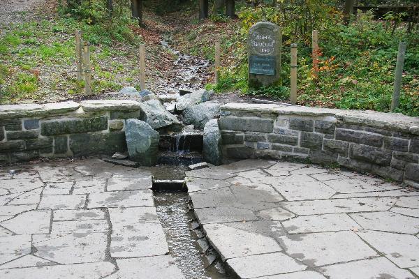
Die Ruhr entspringt einem nur wenige Quadratmeter großen, sumpfig-morastigen Gebiet im Wald, das unter Naturschutz steht. Etwa 20 m unterhalb der Quelle befindet sich ein im Jahre 1980 restauriertes Rondell (666,5 m ü. NN), an dem ein Gedenkstein errichtet wurde. Der Stein erinnert sowohl an ihre erstmalige steinerne Einfassung von 1849 als auch an das Hundertjahresjubiläum von 1949.
Die Ruhrquelle hat im Durchschnitt eine Ergiebigkeit von 2500 Litern pro Stunde.Aus dem Rinnsal wird die Ruhr. Sie fließt über rund 124 Kilometer auf dem Gebiet des Regionalverbands Ruhr und ist für die größte europäischeIndustrieregion, das Ruhrgebiet, namensgebend. Dessen Name erklärt sich daraus, dass die Industrialisierung im ausgehenden 18. Jahrhundert im Bereich des Flusses, wo die Kohle dicht unter der Erdoberfläche gelagert ist, begann.Eine wichtige wirtschaftliche Bedeutung des Flusses liegt heute in der Trink- und Brauchwasserversorgung des Ruhrgebiets sowie in der Energiegewinnung. Im 19. Jahrhundert war die Ruhr zeitweilig die meistbefahrene Wasserstraße Deutschlands. Gegenwärtig findet Güterverkehr nur noch auf den letzten zwölf Flusskilometern zwischen dem Mülheimer Rhein-Ruhr-Hafen und dem Rhein statt. Das Tal der Ruhr ist ein wichtiges Naherholungsgebiet für die Metropolregion Rhein-Ruhr.
Im Unterlauf beträgt die mittlere Abflussmenge der Ruhr am Pegel Mülheim 76 Kubikmeter pro Sekunde, somit ist sie nach ihrer Wasserführung der sechstgrößte Nebenfluss des Rheins.
Geologische Entwicklung
Der hohe Kamm des Rothaargebirges ist in der Erdgeschichte weiter aufgefaltet worden und bis heute erosionsbeständiger als die übrigen Bereiche des umgebenden Mittelgebirges, durch das die Ruhr und ihre Nebenflüsse das Wasser nach Süden ableiten. Bereits nach Verlassen des Rothaargebirge bei Olsberg hat die Ruhr etwa die Hälfte des bis zum Rhein zu überwindenden Höhenunterschiedes überwunden. Dabei wird das Ruhrtal von bis zu 400 Meter höheren Kuppen des Mittelgebirges überragt. Die runden Wölbungen der Berge des Sauerlandes sind die nach langer Erosion entstandenen überbleibsel eines Gebirges, das im Paläozoikum und Mesozoikum entstanden ist. Die Täler wurden hier seit dem Tertiär und Quartär ausgewaschen.
Das mittlere Ruhrtal zeigt dabei eine mehrstufige Terrassenlandschaft, die im Verlauf der wechselnden Vereisungen während des Pleistozän ausgebildet worden ist. Während der Drenthestadien der Saaleeiszeit reichte die Vergletscherung Norddeutschlands bis an die Ruhr vor dem Nordrand des Mittelgebirges heran. Die Oberflächengestalt des mittleren und unteren Ruhrtals wurde damals vom abfließenden Schmelzwasser und von der schiebenden Kraft des Eises geformt. Die Schmelzwasser des Gletschers strömten durch das Ruhrtal nach Westen. Zeitweilig war der Abfluss durch eine Barriere aus Eismassen und Geröll beim heutigen Essen behindert, so dass ein gewaltiger eiszeitlicher See aufgestaut wurde, der das Tal noch beim heutigen Schwerte füllte.
Um den Cache logen zu können, gehe zur Quelle, mache ein Foto von dir (Freiwillig),setze es mit in deinen log und beantworte mir die folgenden Fragen.
Frage 1:
Wie viel Meter über NN liegt die Quelle? ( Nicht das Rondell ) ( Infotafel )
Frage 2:
Wie viel Meter über NN liegt die Einmündung in den Rhein? ( Infotafel )
Frage 3:
Nenne mir eines der am häufigsten Steinvorkommen aus denen das Rothaargebirge besteht. (Internetrecherche)
Sende deine Antwort an folgende Mailadresse:
ZahlAntwort1.ZahlAntwort2@gmx.de
So sollte sie dann aussehen: 123.45@gmx.de
In den Betreff der Mail dein GC-Nickname und die Antwort auf Frage 3
The source of the Ruhr

The source of the Ruhr is the origin of the Ruhr, a 221 km long tributary of the Rhine. It is located in the northeastern part of the Rothaargebirge about 3 km north-east of Winterberg on the northeast slope of 695.7 meters high Ruhr head. Up to the summit, there are about 330 m as the crow flies. The village, which lies closest to the Ruhr source Grönenbach (about 2km away).
The Ruhr springs from a few square meters large, swampy-marshy area in the forest, which is protected. About 20 m below the spring is located in a restored 1980, round tower (666.5 m above sea level. NN) was built where a memorial stone. The stone reminds both of their first stone enclosure of 1849, as well as to the 100-year anniversary of 1949.
The Ruhr source has an average yield of 2500 liters per hour. From the trickle becomes the Ruhr. It flows through approximately 124 kilometers in the area of the Ruhr Regional Association and is Europe's largest industrial region, the Rhurarea, naming. Its name derives from the fact that industrialization in the late 18th Century in the area of the river, where the coal is tightly mounted in the ground began. An important economic significance of the river today is in the drinking and industrial water supply of the Ruhr area and in energy production. In the 19th Century, the Ruhr temporarily busiest waterway in Germany. Currently, freight transport takes place only on the last twelve river miles between the Rhine-Ruhr Mülheim Harbor and the Rhine. The Ruhr Valley is an important recreational area for the Rhine-Ruhr.
In the lower reaches, the mean river discharge at the level of the Ruhr Mülheim 76 cubic meters per second, so it is according to their water supply from the sixth-largest tributary of the Rhine.
Geological Development
The high ridge of Rothaargebirge has unfolded in the Earth continues to this day, and erosion-as the other areas of the surrounding low mountains that are derived through the Ruhr and its tributaries, the water south. Even after leaving the Rothaargebirge in Olsberg dysentery has overcome about half of the Rhine to the height difference to be overcome. In the Ruhr valley is dominated by up to 400 meters high peaks of the mountainous region. The round arches of the mountains of the Sauerland are incurred after a long erosion remnant of a mountain that has arisen in the Paleozoic and Mesozoic. The valleys have been eroded here in Tertiary and Quaternary.
The median Ruhrtal shows while a multi-level terraced landscape, which has been formed in the course of changing glaciations during the Pleistocene.
During the Drenthestadien the Saale ice age glaciation of the North handed over to Germany to the Ruhr to the northern edge of the mountainous region. The surface shape of the middle and lower Ruhr valley was formed by the flowing melt and by the time of the propelling force of the ice. The melting of the glacier flowed through the Ruhr valley to the west. At times, the flow impeded by a barrier of ice and debris at today's eating, so that was dammed a huge glacial lake that filled the valley even at today's sword.
To log the cache take a photo of you (optional) and answer the following questions.
Question1:
How many meter above sea level lies the source? ( Not the rondel) ( Notice board )
Question 2:
How many meters above sea level lies the confluence with the Rhine? ( Notice board )
Question 3:
Give me one of the most common stone deposits that make up the Rothaargebirge. (Internet research)
Send your answer to the following email address:
AnswerQuestion1.AnswerQuestion2@gmx.de
It should look like: 123.45@gmx.de
In the subject of the mail your GC-nickname and the answer to Question 3