 [PL]
[PL]
Grodzisko:
W szczytowej czesci wzgórza Bocheniec w
Jadownikach Podgórnych znajduje sie grodzisko bedace pozostaloscia
wczesnosredniowiecznego grodu. Byl to jeden z grodów plemienia
Wislan i funkcjonowal w IX-X w. Cale zalozenie fortyfikacyjne
skladalo sie z grodu centralnego oraz otoczonego ok 7 m wysokosci
walem ziemno-drewnianym podgrodzia. Obecnie na znacznej czesci
grodziska znajduja sie zabudowania, czyniac jego zarysy malo
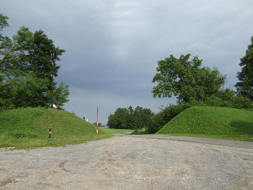
czytelnymi. Najlepiej zachowane sa waly we wschodniej czesci
grodziska - w miejscu, gdzie umieszczona jest skrytka.
W trakcie pobieznych badan archeologicznych natrafiono na grudki
zuzla, który swiadczy o tym, ze mieszkajacy tu ludzie prócz
rolnictwa trudnili sie takze hutnictwem.
Ponizej grodziska, pod wspólrzednymi N 49° 56.564 E 020° 39.006
znajduje sie zródlo z cudowna woda.
Mozna podjechac samochodem prawie pod sama skrytke, gdzie znajduje
sie dogodny parking.
Skrytka:
Pojemnik zawiera logbook i olówek.
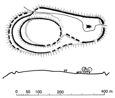
Plan grodziska wg G. Lenczyka
 [EN]
[EN]
The hill fort:
On the top of Bocheniec hill in Jadowniki
Podgórne there is a hill fort - the remains of an early-medieval
grad (a Slavic settlement). This grad existed in 9.-10. century and
belonged to Vistulans tribe. The whole fortification originally
comprised a central grad and an exterior part surrounded by about 7
m high rampart made out of earth and wood. Presently, the majority
of the hill fort is covered by buildings that obscure its original
shape. The best preserved ramparts are located in the eastern part
of the hill fort - at the spot where the cache is hidden.
During a cursory archaeological research clods of slag were found,
testifying that people who lived there worked not only as farmers
but also in metallurgy.
Below the hill fort, at coordinates N 49° 56.564 E 020° 39.006
there is a holy well.
You can park your car just near the cache, where there is a handy
car park.
The cache:
The container includes a logbook and a
pencil.