Tsambika Dunes EarthCache
-
Difficulty:
-

-
Terrain:
-

Size:  (not chosen)
Please note Use of geocaching.com services is subject to the terms and conditions
in our disclaimer.
Besucht einen der schönsten Strände auf Rhodos und seht euch die einzige Düne der Insel an. Achtung: Der Sand, um den es hier geht, ist in der Regel extrem heiß. Außerdem ist eine der Aufgaben mit ein wenig Kletterei verbunden - in der Sonne Griechenlands kann das sehr schweißtreibend sein.
Wer seinen Urlaub auf Rhodos verbringt möchte natürlich den schönsten Strand, das klarste Wasser und die romantischste Bucht finden. Dieser Earth hat einiges davon zu bieten - nicht alles aber auch ein wenig mehr! Nämlich die einzige Düne der Insel, denn ansonsten ist Rhodos eher für steinigen Untergrund bekannt.
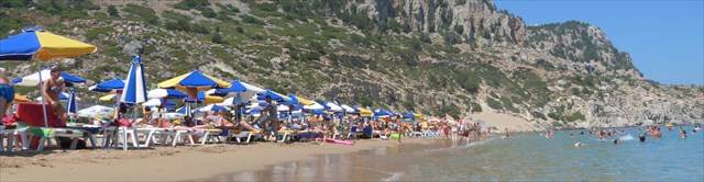
In vielen Reiseführern wird er als der schönste Strand der Insel geadelt: Tsambika Beach. Wer die Steilkurven hinunterfährt und auf die gut zwei Kilometer lange und von hohen Felsen eingerahmte Bucht blickt, kann diesem Urteil nur zustimmen. Es handelt sich um den einzigen echten Sandstrand der Insel.
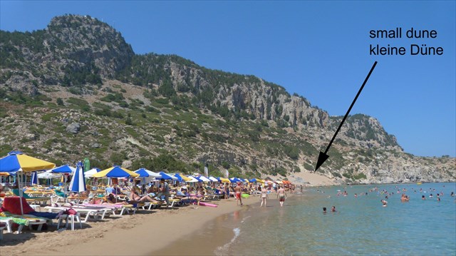
Das hier ein Sandstrand liegt hat eine einfache Begebenheit - es handelt sich um eine Düne. Diese wurde zum Teil von Menschenhand in einen "Traumsandstrand" umgewandelt um nicht zu sagen planiert... Rechts und links der Liegen sind die vom Wind aufgehäuften Dünen aber deutlich zu erkennen, denn der Strand von Tsambika liegt zwischen zwei kleinen Bergen, die bis ans Wasser heranreichen.
Eine Küste und damit auch eine Bucht und ein Strand sind geologische Formen - insofern sie nicht von Menschenhand geschaffen wurden. Sie besteht in der Regel aus losen Partikeln der unterschiedlichsten Materialien, wie z.B. Stein oder Sand. Verschiedene Einflussfaktoren gestalten das Aussehen der Küste oder eines Strandes. Einer der entscheidenden Faktoren sind die Wasserwellen. Diese können zu einem Abbaubereich führen und die Landmasse (vor allem weicher Untergrund wie Sand) im Lauf der Zeit erheblich verkleinern.
Entstehung von Dünen
Dünen sind Ablagerungen aus unverfestigten Sand, die vor allem an Stränden und in Wüsten auftauchen. Die durch Wind verursachte Bewegung der Sandkörner führt dazu, dass sich ein kleiner Hügel zu bilden beginnt, wenn der Sand an ein Hindernis gerät. Neue Sandkörner kommen zu diesen dazu und die Düne gewinnt an Höhe. Sie entstehen also aufgrund des Zusammenwirkens von Sandzufuhr, Windstärke und Vegetationsbedeckung. Die Ausprägung dieser Prozessfaktoren bestimmt auch, welcher Dünentyp entsteht (Dünenklassifikation).
Es gibt unterschiedliche Klassifizierungen von Küstendünen, diese sind hier nachzulesen.
Die Dünen besitzen einen lang gestreckten Kamm im rechten Winkel zur Windrichtung. Verändert sich die Windrichtung, werden sie gebrochen und andere Dünen, die sich schneller bewegen - sogenannte Wanderdünen - treten auf. Dies spielt hier aber keine Rolle. Aus der Vogelperspektive betrachtet, ist die Form einer Düne meist halbmondförmig (Sicheldüne), wobei ihre Spitzen in Windrichtung weisen. Diese Spitzen entstehen, weil die Enden sich schneller bewegen als der Mittelteil, in dem sich der meiste Sand befindet.
Auf der windzugewandten Seite, der flachen Luvseite, wird der Sand durch Saltation den Dünenhang hinaufgetrieben. Hierbei findet eine Korngrößensortierung statt: Zum Kamm hin nimmt in der Regel die Korngröße ab. Vom Dünenkamm fällt der Sand über die windabgewandte Seite, den steilen Leehang, hinunter. Die Neigung des Leehanges entspricht dem Winkel der inneren Reibung für lose geschütteten Sand, also ungefähr 30°.

Dünen entstehen auf der Erde in Wüsten und an Küsten. Diese unterscheiden sich vor allem durch die unterschiedlichen Transportbedingungen für Sand am Boden. In der Wüste ist es trocken, so dass der Sand durch den Wind transportiert werden kann und ein Sandaustausch zwischen den Dünen stattfinden kann. An den Küsten hingegen ist es meistens feucht und Vegetation vorhanden, so dass der Sandtransport behindert wird. Der Sand für diesen Dünentyp wird vom Meeresstrand herantransportiert. Wird der Dünensand nicht durch Vegetation beeinflusst, entstehen Sicheldünen (Barchane), in Gebieten mit Vegetationseinfluss Parabeldünen.
Strände und Sandbänke
An die Küstenlinie angeschwemmtes Material lagert sich an bestimmten Orten ab, wobei Strände, Barren und Sandbänke entstehen. Hinzu kommt die Erosion der Küsten durch die Wasserkraft.
Die Bildung von Dünen kann auch mit dem helmholtzschen Gesetz erklärt werden: „Strömen zwei Medien unterschiedlicher Dichte aneinander vorbei, so ergibt sich eine wellenförmige Begrenzungsfläche.“ Diese ist bei den allgemein herrschenden Windstärken strömungsenergetisch günstiger als eine ebene Begrenzungsfläche (Cw-Wert). Dabei unterscheidet man Großformen, die eigentlichen Dünen und Kleinformen, die Rippeln. Während Dünen beträchtliche Ausmaße und Mächtigkeiten erreichen können, haben Rippeln meist nur eine Höhe von wenigen Zentimetern, bei einer Erstreckung im Dezimeterbereich.
Dazu bei Wikipedia:
An der deutschen Nordseeküste liegt der Sandstrand von Amrum im Anspülbereich. Er ist mit einer Breite von nahezu zwei Kilometern einer der breitesten Sandstrände Europas. Der Strand der Nachbarinsel Sylt wird abgebaut und weist jährlich einen beachtlichen Landverlust auf. Diesen Prozess begegnet man durch Sandvorspülungen, indem Sand vom Meeresboden mit Baggerschiffen abgesaugt und an den Strand über Rohrleitungen zurückgespült wird.
Auch viele Sandstrände am Mittelmeer leiden an Flächenschwund. Bedingt ist die Reduzierung zum einen dadurch, dass der Mensch - in der Absicht mehr Strandfläche zu schaffen -, die pflanzenbewachsene Dünenlandschaften zu vegetationslosem Flachstrand planiert und in Folge dessen Erosion eingesetzt hat. Die zweite Ursache für den Strandschwund ist die Erderwärmung, die den Meeresspiegel ansteigen lässt, was wiederum allmählich den Sandbestand abträgt. Ein Beispiel ist der „Schickeria-Strand“ Macchiatonda beim toskanischen Capalbio, der 1975 noch etwa 50 Meter breit war und 2005 (auf Grund der zwei angeführten Faktoren) nur noch einen Rest von 10 Meter Breite hat.

Der benachbarte Earthcache "Afantou Beach" GC26983 setzt sich ebenfalls mit der Entstehung von Küsten und Stränden auseinander, aber auf andere Weise.
Am Tsambika-Strand spielen jedoch nicht die Wellen sondern der Wind die entscheidende Rolle. Das Wasser ist hier sehr flach verlaufend und der inlandige Wind trägt die kleinen Sandpartikel fort und schüttet sie an den Berghängen zu Dünen auf.
Wikipedia zum Thema Dünen.
Um diesen Cache zu loggen:
- Beschreibe mit deinen eigenen Worten welche der beschriebenen Faktoren für die hier zu sehenden Dünen zutreffen bzw. nicht zutreffen.
- Bau ein 3D-Modell der Tsambika-Bucht. Die beiden Dünen (rechts und links) sollten klar zu erkennen sein, ebenfalls die grobe Form und die Windrichtung, die zur Entstehung führt, ggf. weitere Faktoren, die für die Dünenentstehung wichtig sind. Macht ein Foto vom Modell und ladet es mit dem Log hoch.
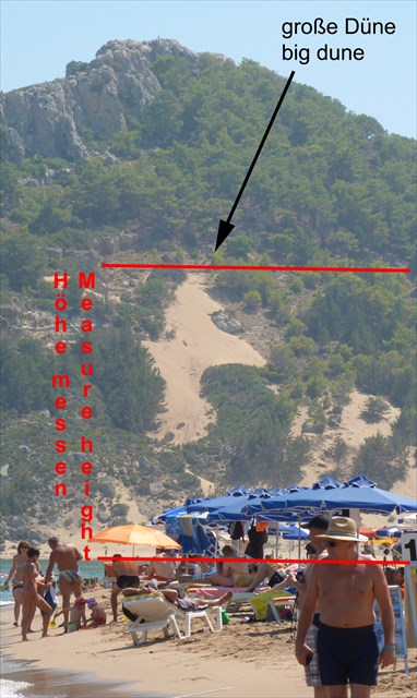
- Misst die Höhe der höheren, rechten Düne (rechts mit Blick vom Strand aufs Meer!) - also der Unterschied zwischen Strand und der Dünenoberkante. Dabei solltet ihr nicht die Düne direkt erklimmen, denn das wären jeweils ein Schritt vor, zwei zurück. Rechts neben der Düne (ca. 250m) verläuft ein breiter, befahrbarer Weg. Folgt diesem bis auf die vermutete Höhe der oberen Spitze und sucht euch dann einen Weg durch den kleinen Wald bis zur Düne. Genießt dabei den Blick über die Bucht.
- Die Antworten müssen vor dem Loggen per Mail beantwortet werden!
English
Visit one of the most beautiful beaches on Rhodes and take a look at the dunes there. Note: the sand, which is at stake here, is usually extremely hot. In addition, for one of the tasks you have to do some climbing - in the Greek sun it can be very strenuous.
Anyone who spends his holidays on Rhodes wants to find the most beautiful beach, the clearest water and most romantic bay. This Earthcache has to offer a lot - not all but even some more! The only dune on Rhodes, which is normally known for its rocky underground.
Some travel guides point it out as the most beautiful beach on the island: Tsambika Beach. Everyone going down the steep turns to the two kilometre long bay, which is framed by high cliffs, can only agree with this judgment. It is the only real sand beach on the island.
That this here is a sandy beach is a simple story - it is a dune. The dune was partly transformed into a flat "dream beach" by human hands, not to say bulldozes... Right and left of the sun beds you can see the wind piled dunes clearly, because the beach Tsambika lies between two small mountains, which border right down to the water.
A coast, and thus a bay and a beach are geological formations - so far they have not been created by human hands. Usually it consists of loose particles of different materials such as stones or sand. Several factors shape the appearance of the coast or a beach. One of the decisive factors are the water waves. This can lead to the destruction and removal of the land mass (especially in soft and loose ground such as sand) significantly.
Formation of dunes
Dunes are deposits of unconsolidated sand, which appear mainly on beaches and deserts. Caused by wind, the sand grains movement begins to form a small hill, when the sand runs into an obstacle. New grains of sand come in addition and the dune gains height. So they arise due to the interaction of sand supply, wind and vegetation cover. The peculiarity of these factors determines which dune type is created (dunes classification).
The dunes have an elongated ridge at right angles to the wind direction. A changing of the wind direction they broke up and other dunes that can move faster - so-called shifting sand dunes - occur. This plays no role here, however. From a bird's eye view, a dune is most times crescent-shaped, with their tips pointing in the direction of wind. These peaks arise because the ends move faster than the central portion in which the most sand is located.
On the flat windward side the sand is driven up by saltation. And a particle sizing takes place: Closer to the ridge the grain size normally decrease. From the ridge the sand falls down on the sharply downwind side. The slope of the downwind side corresponds to the angle of internal friction to bulk sand, which is about 30°.
Dunes occur in deserts and on coasts. These differ mainly by the different transport conditions for sand on the floor. In the desert it is dry, so the sand can be transported by wind and sand replacement can take place between the dunes. On the other hand, at the cost it is usually humid and you can find coastal vegetation, the sand transport is hindered. If dunes are not influenced by vegetation crescent dunes built up, in areas with vegetation influence parabolic dunes.
Beaches and sand bars
On the shoreline alluvial material is deposited in certain locations, so beaches, bars and sand banks arises. In addition, coastal erosion is due to the water power.
The formation of dunes can also be explained by Helmholtz's law: "two media of different density streams past each other, the result is a wavy boundary surface." In general this is more energetically favourable for the prevailing winds flow than a planar boundary surface. A distinction is made into large-scale forms, the actual dunes and small forms, the ripples. While dunes can reach considerable size and thickness, ripples usually have a height of only a few centimetres, with an extension in the decimetre range.
Wikipedia explains this subject:
On the German North Sea coast, the sandy beach of Amrum is in the wash up area. With a wide of nearly two kilometres it is one of the widest in Europe. The beach of the neighbouring island of Sylt is considering a significant loss of land. This process is counteracted by beach nourishment by sand that is extracted from the seabed using dredgers and flushed back to the beach via pipelines.
Many sandy beaches in the Mediterranean are suffering from shrinkage. The reduction is contingent on the fact that mankind are bulldozing these areas without leaving vegetations the stop the erosion. The second cause for the loss of beaches is global warming, the sea level rises, which in turn gradually erodes the sand stock. An example is the Macchiatonda beach the Tuscan Capalbio, 1975 it was about 50 feet wide and 2005 (due to the two mentioned factors) it only had a remain of 10 meters.
The neighbouring Earthcache "Afantou Beach" GC26983is also dealing with the development of coasts and beaches, but in other ways.
At Tsambika beach not the waves but the wind is the decisive reason. The water here is very flat and the onshore wind carries away the small particles of sand to form the dunes at the mountain slopes.
Find more information about dunes at Wikipedia.
To log this cache:
- Describe with your own words what reason and conditions can be found at this particular dune, e.g. have no relevance.
- Build a 3D-model of Tsambika Bay. The two dunes (right and left) should be clearly visible, as well as their rough shape and the wind direction and other factors for the dune building up. Take a picture and load it up in you log.
- Measures the higher dune on your right (right while looking from the beach onto the open water!) - the difference in height between the beach and dune top edge. You should not climb the dune directly, because that would mean one step forward, two steps back. To the right of the dune (250m) there is a wide, sandy but drivable way. Follow this one up to the assumed level of the upper tip and then seek out a path through the small forest above to the dune. Enjoy the panoramic view over the bay.
You have to send the answers befor logging per Mail!
Ελληνικά
Επισκεφθείτε ναι από τις ομορφότερες παραλίες της Ρόδου και ρίξτε μια ματιά στους εκεί αμμόλοφους (θίνες). Σημείωση: Η άμμος που υπάρχει εκεί συνήθως είναι πολύ καυτή. Επίσης, σε μία από τις αποστολές σας εδώ είναι και λίγη αναρρίχηση η οποία στον ελληνικό ήλιο μπορεί να είναι πολύ επίπονη.
Όποιος περνά τις διακοπές του στη Ρόδο θέλει να βρει την πιο όμορφη παραλία της, τα καθαρότερα νερά και τον πιο ρομαντικό κόλπο. Αυτή η Earthcache έχει να προσφέρει πολλά - ακόμη περισσότερα από όσα φαντάζεστε!
Είναι οι μόνοι αμμόλοφοι στην Ρόδο, η οποία είναι συνήθως γνωστή για το βραχώδες υπέδαφός της.
Ορισμένοι ταξιδιωτικοί οδηγοί επισημαίνουν ως την ομορφότερη παραλία του νησιού την παραλία Τσαμπίκας. Ο καθένας που θα πάρει τον δρόμο με τις απότομες στροφές προς τον δύο χιλιομέτρων κόλπο, ο οποίος πλαισιώνεται από ψηλούς γκρεμούς, δεν μπορεί παρά να συμφωνήσει με την απόφαση αυτή. Είναι η μόνη πραγματική παραλία με άμμο του νησιού.
Αυτό που εδώ είναι μία αμμώδης παραλία είναι με απλά λόγια - ένας αμμόλοφος. Ο αμμόλοφος έχει μεταμορφωθεί σε μια επίπεδη μερικώς ονειρεμένη παραλία από τα ανθρώπινα χέρια, για να μην πω με μπουλντόζες ... Δεξιά και αριστερά από τις ξαπλώστρες μπορείτε να δείτε καθαρά τους αμμόλοφους φτιαγμένους από τον αέρα, μιας και η παραλία Τσαμπίκας βρίσκεται ανάμεσα σε δύο μικρά βουνά, τα οποία συνορεύουν κάτω από το νερό.
Μια ακτή και επομένως ένας κόλπος και μια παραλία είναι γεωλογικοί σχηματισμοί που μέχρι σήμερα δεν έχουν δημιουργηθεί από τα ανθρώπινα χέρια. Συνήθως αποτελούνται από σαθρά υπολείμματα από διάφορα υλικά, όπως πέτρες ή άμμο. Διάφοροι παράγοντες διαμορφώνουν την εμφάνιση της ακτής ή μιας παραλίας. Ένας από τους καθοριστικούς παράγοντες είναι τα κύματα του νερού. Αυτό μπορεί να οδηγήσει στην καταστροφή και την αφαίρεση της μάζας της γης (ιδιαίτερα σε μαλακό και χαλαρό έδαφος, όπως είναι η άμμος), σημαντικά.
Σχηματισμός των αμμόλοφων
Οι θίνες (αμμόλοφοι) είναι καταθέσεις μη ενοποιημένης άμμου, και εμφανίζονται κυρίως σε παραλίες και ερήμους. Προκαλούνται από τον άνεμο, η κίνηση των κόκκων άμμου ξεκινάει να σχηματίζει ένα μικρό λόφο, όταν η άμμος πέσει πάνω σε κάποιο εμπόδιο. Με την προσθήκη ολοένα και νέων κόκκων άμμου η θίνη ψηλώνει. Έτσι μεγαλώνουν και σηκώνονται λόγω της αλληλεπίδρασης της προσφοράς άμμου, του ανέμου και της βλάστησης. Η ιδιαιτερότητα αυτών των παραγόντων καθορίζει ποιος τύπος αμμόλοφου δημιουργείται (Ταξινόμηση Αμμολόφων (Θινών)).
Οι θίνες έχουν επιμήκη κορυφογραμμή με κάθετες γωνίες προς την κατεύθυνση του ανέμου. Με μία αλλαγή της κατεύθυνσης του ανέμου χωρίζουν και νέες θίνες που μπορούν να κινηθούν γρηγορότερα – κοινώς ονομαζόμενες μετατοπιζόμενοι αμμόλοφοι – εμφανίζονται. Αυτό δεν παίζει κανένα ρόλο εδώ, όμως από ψηλά, ένας αμμόλοφος έχει τις περισσότερες φορές το σχήμα μισοφέγγαρου, με τις άκρες του να δείχνουν προς την κατεύθυνση του ανέμου. Οι κορυφές αυτές οφείλονται στο γεγονός ότι τα άκρα κινούνται ταχύτερα από ότι το κεντρικό τμήμα στο οποίο βρίσκεται και η περισσότερη άμμος.
Από την επίπεδη προσήνεμη πλευρά η άμμος κατευθύνεται αλματωδώς προς τα πάνω. Και μία διαφοροποίηση μεγέθους στα σωματίδια πραγματοποιείται: Πιο κοντά στην κορυφογραμμή το μέγεθος του κόκκου άμμου συνήθως μειώνονται. Από την κορυφογραμμή η άμμος πέφτει απότομα στην υπήνεμο πλευρά. Η κλίση της υπήνεμου πλευράς αντιστοιχεί στην γωνία εσωτερικής τριβής επί του όγκου της άμμου, που είναι περίπου 30 °.
Οι θίνες εμφανίζονται σε Ερήμους και σε ακτές. Αυτές διαφέρουν κυρίως από τις διαφορετικές συνθήκες μεταφοράς της άμμου στο έδαφος.
Στην έρημο υπάρχει ξηρασία, οπότε η άμμος μπορεί να μεταφέρετε από τον άνεμο και αντικατάσταση άμμου μπορεί να λάβει χώρα μεταξύ των αμμόλοφων. Από την άλλη, στην ακτή έχει συνήθως υγρασία και μπορεί να υπάρχει παράκτια βλάστηση, που παρεμποδίζει την μεταφορά της άμμου. Αν οι αμμόλοφοι δεν επηρεάζονται από βλάστηση δημιουργούνται αμμόλοφοι μισοφέγγαρο, ενώ σε περιοχές με βλάστηση που επηρεάζει δημιουργούνται παραβολικοί αμμόλοφοι.
Παραλίες και διάδρομοι άμμου
Στην ακτογραμμή προσχωσιγενή υλικά κατατίθεται σε συγκεκριμένες περιοχές, έτσι εμφανίζονται παραλίες, και διάδρομοι άμμου. Επιπλέον, η διάβρωση των ακτών οφείλεται στη δύναμη του νερού. Ο σχηματισμός των αμμόλοφων μπορεί επίσης να εξηγηθεί από το νόμο του Helmholtz: "όταν δύο μέσα διαφορετικών ρευμάτων πυκνότητας είναι το ένα μετά το άλλο, το αποτέλεσμα είναι μια κυματιστή επιφάνεια". Σε γενικές γραμμές αυτό είναι πιο ενεργειακά ευνοϊκό για την επικρατούσα ροή ανέμων από μια επίπεδη επιφάνεια. Γίνεται ένας διαχωρισμός σε μεγάλης κλίμακας μορφές, τις πραγματικές θίνες και τις μικρές μορφές, τους κυματισμούς. Ενώ οι αμμοθίνες μπορούν να φτάσουν σε ένα σημαντικό μέγεθος και πάχος, οι κυματισμοί έχουν συνήθως ύψος μόνο λίγα εκατοστά, με μία επέκταση στο εύρος δεκατόμετρου.
Η Wikipedia εξηγεί αυτό το θέμα:
Στη γερμανική ακτή της Βόρειας Θάλασσας, η αμμώδης παραλία του Amrum είναι στην περιοχή εκβρασμού. Με πλάτος περίπου δύο χιλιόμετρα, είναι μία από τις φαρδύτερες στην Ευρώπη. Η γειτονική παραλία του νησιού Sylt εξετάζει το ενδεχόμενο μιας σημαντικής απώλειας γης. Η διαδικασία αυτή εξουδετερώνεται από ανατροφοδότηση της παραλίας με άμμο που εξάγεται από τις βυθό με γερανούς-εκσκαφείς και επανατοποθετείτε στην παραλία μέσω αγωγών.
Πολλές αμμώδεις παραλίες της Μεσογείου πλήττονται από συρρίκνωση. Η μείωση εξαρτάται από το γεγονός ότι η ανθρωπότητα κάνει καθαρισμούς και εκσκαφές σε αυτές τις περιοχές, χωρίς να αφήνει την βλάστηση να σταματήσει τη διάβρωση. Η δεύτερη αιτία για την απώλεια των παραλιών είναι η υπερθέρμανση του πλανήτη, και η άνοδος της στάθμης της θάλασσας, η οποία με τη σειρά της διαβρώνει σταδιακά το απόθεμα άμμου. Ένα παράδειγμα είναι η παραλία Macchiatonda της Τοσκάνης Capalbio, το 1975 ήταν περίπου 50 μέτρα πλάτος και το 2005 (λόγω των δύο προαναφερόμενων παραγόντων) είχαν μείνει μόνο 10 μέτρα.
Η Γειτονική Earthcache "Afantou Beach" GC26983 ασχολείται επίσεις με την ανάπτυξη των ακτών και παραλιών, αλλά και με άλλους τρόπους.
Στην παραλία Τσαμπίκας δεν είναι τα κύματα, αλλά ο άνεμος… ο καθοριστικός λόγος. Το νερό εδώ είναι πολύ επίπεδο στην ξηρά και ο άνεμος παρασύρει τα μικρά σωματίδια άμμου για να σχηματίσουν τους αμμόλοφους στις πλαγιές των βουνών.
Βρείτε περισσότερες πληροφορίες σχετικά με τις Θίνες στην Wikipedia.
Για να κάνετε καταγραφή (log) της κρύπτης αυτής:
- Περιγράψτε με δικά σας λόγια ποιο λόγο και προϋποθέσεις μπορούν να βρεθούν στο συγκεκριμένο αμμόλοφο, π.χ. δεν έχουν καμία σχέση.
- Φτιάξτε ένα τρισδιάστατο μοντέλο της Παραλίας Τσαμπίκας. Οι δύο θίνες (αριστερά και δεξιά) πρέπει να είναι καθαρά ορατές, καθώς και η τραχιά μορφή τους, η κατεύθυνση του ανέμου και άλλων παραγόντων για τη δημιουργία των αμμόλοφων. Τραβήξτε μια φωτογραφία για να τη φορτώσετε στην καταγραφή (log) σας.
- Μετρήστε το μεγαλύτερο αμμόλοφο (θίνη) στα δεξιά σας (δεξιά κοιτάζοντας από την παραλία προς την θάλασσα!) - τη διαφορά στο ύψος μεταξύ της παραλίας και την κορυφή της θίνης. Δεν θα πρέπει να ανεβείτε στο αμμόλοφο άμεσα, γιατί αυτό θα σήμαινε ένα βήμα μπροστά, δύο βήματα πίσω. Στα δεξιά του αμμόλοφου (250μ) υπάρχει ένας μεγάλος, αμμώδης αλλά που μπορείς να οδηγήσεις σε αυτόν, δρόμο.
Ακολουθήστε αυτόν τον δρόμο έως το τέλος του και στη συνέχεια να αναζητήστε μία διαδρομή μέσα από το μικρό δασάκι επάνω για τον αμμόλοφο.
Απολαύστε την πανοραμική θέα στον κόλπο.
Thank you GATOULIS for the greek translation!
Additional Hints
(Decrypt)
Lbh unir gb fraq lbhe nafjref cre znvy orsber ybttvat!