About Village Sign Caches
|
 ⠀ ⠀ |
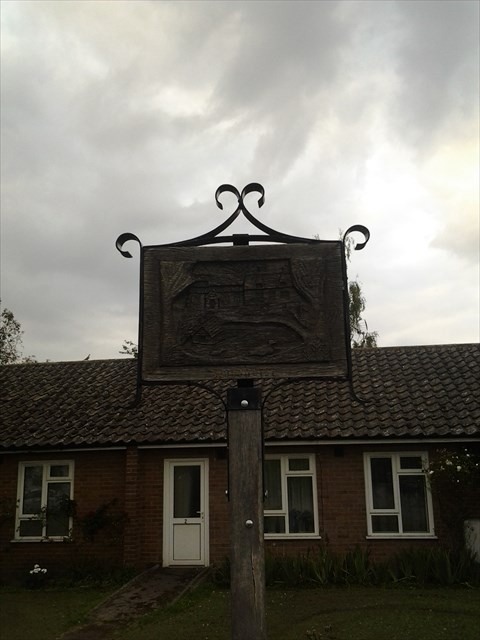
This cache belongs to the Village Sign Series, a series of caches based on ornate signs that depict the heritage, history and culture of the villages that put them up (generally on the village green!).
The signs can be made of different materials from fibreglass to wood, from forged steel to stone. They can depict anything from local industry to historical events. The tradition probably started in Norfolk or Suffolk and has now spread across most of the country so we thought we would base a series on them!
|
More information, bookmarks and statistics can be found at the Village Signs Website
If anybody would like to expand the Village Sign Series, please do.
I would ask that you request a number for your cache first at www.villagesignseries.co.uk
so we can keep track of the Village Sign numbers and names to avoid duplication.
Woodhurst is one of the best surviving examples of an Anglo-Saxon ring village in England. It is thought that it was originally formed by the track through the forest being widened for about half a mile, and a fence being put round it with a gate at either end. The actual date that the village was formed is not known but it is thought to have been Roman-British. Roman pottery remains have been found near the village, and in the recent excavations in the field next to Wheatsheaf Road to lay a new water main, Roman coins have been found. During 1949 when Moot Way was being built, evidence of Anglo Saxon occupation was found and also some Medieval burials which were thought to be Plague deaths.
The shape of the village has not altered over the centuries although beginning with the church and then the Manor House, buildings were built outside the ring. The name Woodhurst has over the years been spelt Wuduhyrst, Wodehyrst, Wodehirst, Woodhurste and Wood Hurst. There are several explanations as to the original meaning of the name, but hyrst was Old English for 'a wooded hill'.
Woodhurst was not mentioned in the Domesday Book, but as the church was until 1968 a chapelry of St Ives, it is probable that the church and a description of the area and landowners are recorded under Slepe (the original name for St Ives). The oldest part of the present church, the north wall of the nave, was built in the 12th century. The south arcade was built in the 14th century and the chancel is relatively modern having been added in the 19th century. The timber bell-turret was probably built in the early 17th century, but of the three original bells only one remains.
Owing to two disastrous fires in the village in 1834 and 1877, there are few old houses in the village. 'Horseshoe Cottage' opposite the pond was built in the 17th century and was until 1922 a public house called The Horse Shoes. At one time there were six public houses in the parish of Woodhurst. The oldest house in the village is thought to be 'Swan Weir' which dates from the late 16th century.
The cache is NOT at the village sign, but you need to visit it to collect the required information. Please do not go climbing all over the sign! You can collect the information from the public footpath.
The Wi donated this sign in which month? January = 1, February = 2 etc. Assign this month to G
...and in which year HAJK
When was the sign restored? LMEN
B = G + 1
C = K - L
D = J /2
F = D + N
The cache can be found at N52 21.ABC W000 04.DEF
You can check your answers for this puzzle on GeoChecker.com.