| Trackable Options |
 Found this item? Log in.
 |
 Printable information sheet to attach to Natchez Trace Parkway 8: Tracing Paths
Print Info Sheet
Printable information sheet to attach to Natchez Trace Parkway 8: Tracing Paths
Print Info Sheet |
| There are 2 users watching this listing. |
This is not collectible.
The mission of this travel bug is to travel across the country and visit trails. Trails may range from those made by people thousands of years ago to trails made recently by city managers.
When you drop off this TB at a trail:
- if it is a historic trail, please log a line or two about the people who established the trail
- if it is part of the National Trails System, please log which trail
- if it is a modern trail, please log the type of trail
We love to have pictures posted on the logs!
 Please remember that:
- National Park Service policy does not allow people to leave SWAG in National Park caches.
- All National Park Service Geocaching sites must be approved by the relevant National Park unit.
- This travel bug is the property of the National Park Service.
American Indians, for thousands of years prior to the establishment of the Natchez Trace Parkway, used a corridor of foot trails now commemorated by the Parkway. Parts of these foot trails are still used by people enjoying outdoor recreation.
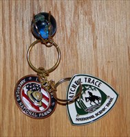
The Natchez Trace Parkway 8: Tracing Paths travel bug is attached to a Natchez Trace National Scenic Trail (NATT) medallion. The Natchez Trace Parkway encompasses the NATT, which is the only National Scenic Trail to be totally within the boundaries of a National Park. The footpath of the scenic trail is in five sections connected by Parkway green-way. Most sections include parts of the Old Natchez Trace Trail.
The southernmost section of NATT is Potkopinu, is between mileposts 17-20, near Natchez, MS. Footsteps of people from the past have compressed the soft loess soil to the extent that in some places, the forest floor is now above a hiker’s head. Potkopinu is the Natchez Indian word for Little Valley.
The Rocky Springs section between mileposts 52.4-59, passes through the Rocky Springs campground and picnic area. Hikers walk on sections of the original Old Trace.
The Yockanookany section between mileposts 108-131, is the longest footpath section. It is named for a river that passes through this tribal homeland of the Choctaw people.
Prairie is not the first land-type that usually comes to mind when someone thinks of Mississippi, but the Blackland Prairie section of the NATT, between mileposts 260.8-266, passes through the Blackbelt (blackland) prairie. The Chickasaw people established numerous villages along the rich prairie soils where they farmed for centuries. They frequently burned the prairie to maintain open land, ensuring more living space, better farmland, and unrestricted views of approaching visitors.
The Highland Rim section of the NATT, between mileposts 407.9-427.4 is the northern-most section of trail and is popular for horseback riding. This trail is much different than the others as it traverses some of the hills around the central basin of Tennessee. The American Indian tribes that are known to have lived around the Highland Rim are Cherokee, Yuchi, Shawnee, Creek, Chickasaw and more.
See www.nps.gov/natt for Natchez Trace National Scenic Trail
See http://www.nps.gov/nts/ for the Nation Trail System
See http://www.nps.gov/stsp and http://www.geocaching.com/adventures/geotours/starspangledbanner for the Star Spangled Banner Geotour, a National Park Service partnership sponsored GeoTour Trail.
See http://www.nps.gov/cajo and http://www.geocaching.com/adventures/geotours/captainjohnsmith for the Captain John Smith Geotour, a National Park Service partnership sponsored GeoTour Trail.