3 Jan 08
 Coin Picture as Found Coin found at Aughanbaugh
|
17 Aug 07
 You've got a friend in Pennsylvania! Gives new meaning to PA's tourism slogan. This fellow was buzzing with happiness to see me after a BFT hike on an earlier date.
|
29 Jul 07
 The backside of Gillespie Pt. Either road hike back down Big Run Rd. or continue on the MST until the footbridge. Then a bushwhack across the creek to a logging grade dumping onto a shorter road hike.
|
29 Jul 07
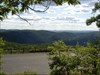
 View northward from Gillespie Point Did the 1.4 mi hike in 50 min. Not bad considering my weight gain & the humidity.
|
29 Jul 07
 View south down Pine Creek from Gillespie Pt After ~1000' elevation gain over ~0.9 mi on MST. Humidity caused suffering!
|
29 Jul 07
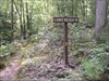
 Start of the climb to Gillespie Point on the MST ~0.5 mi road hike from Blackwell parking area to MidState Trailhead
|
29 Jul 07
 Pine Creek Rail-to-Trail, headed south Located in the PA Grand Canyon
|
29 Jul 07
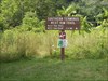 West Rim Trail, Southern Terminus Across from the Rattlesnake Rocks parking area, ~1 mi south of Blackwell parking area
|
29 Jul 07
 Black Forest Trailhead, near Slate Run Just up the forest road from the Manor Hotel where we ate lunch.
|
29 Jul 07
 Pine Trail, ~0.3 mi from cache on other side of Pine Creek
|
29 Jul 07
 Lance Raisch Trail, ~0.3 mi from cache On the opposite side of Pine Creek on Naval Run Rd. Some nice campsites here. I think you can access the BFT with this or Pine Trail.
|
21 Jul 07
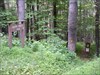
 LT & High Rock Trail Blazes LT: yellow with red bar and / or red can lid with yellow LT; High Rock: must have been reblazed red from previous yellow; note the rock outcroppings & hemlocks the LT frequently goes thru
|
21 Jul 07
 View from High Rock Vista to Canyon Vista Looking directly at the clearing to Canyon Vista
|
21 Jul 07
 View from High Rock Vista Looking directly at the clearing for World's End Vista and looking down upon Loyalsock Creek
|
21 Jul 07
 High Knob Overlook view (N-NE?) On the drive In / Out.
|
21 Jul 07
 DNF picture at High Knob Memorial cache Site of a DNF and the beginning of our hike. We took High Knob Trail down, then a multi-use trail, then the LT for the cache & our return
|
21 Jul 07
 High Knob Overlook view (E-SE?)
|
21 Jul 07
 High Knob Overlook view (S-SW?)
|
21 Jul 07
 A VICTORY picture for Trail Finder Halfway on the Loyalsock Trail with EMGT Compass Rose Geocoin #48
|
21 Jul 07
 High Knob Overlook view (SW-W?)
|