Walden Pond was once home to the renowned author and Concord native, Henry David Thoreau. In 1845, Thoreau accepted an offer from writer and friend, Ralph Waldo Emerson, to use a Emerson's newly purchased woodlot at Walden Pond. Thoreau went to live and work at Walden Pond for two years, keeping a journal of his thoughts and his encounters with nature and society. He spent the next seven years collecting and revising his observations, and in 1854, published them in the book, first making this area famous, Walden.
In 1922, the Emerson, Forbes, and Heywood families granted approximately 80 acres surrounding the pond to the Commonwealth with the stipulation of "preserving the Walden of Emerson and Thoreau for the public who wish to enjoy the pond, woods, and nature." In 1965, the National Park Service designated Walden Pond as a Registered National Historic Landmark. In 1975, it became part of the Massachusetts State Parks system and remains managed today by the Department of Conservation and Recreation.
This EarthCache will focus on two features of the park, kettle lakes and eskers.
Kettle Lakes
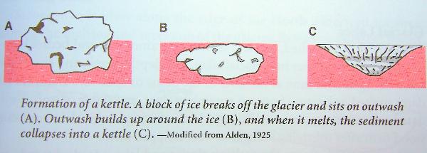
Kettle lakes are formed when stagnant blocks of ice break off from the glacier and once downstream from the glacial margin may become partly or completely buried by accumulating sand and gravel. Once they are buried in the glacial outwash the ice begins to melt. As these large blocks of ice melt, the unsupported glacial material collapses and forms craterlike depressions, known as kettle holes. A kettle hole contains water if the groundwater level is higher than the bottom of the kettle or if the base beneath the kettle is not porous and traps rainwater. Most kettle lakes have no streams flowing either into or out of them. Walden Pond is a kettle formed over 12,000 years ago, in the delta plain, when the last glacier to cover New England melted away.
Eskers
Eskers are long, sinuous or meandering ridges of glacial debris that resemble stream channels on a map. The steep, narrow ridges can be 30 or 35 feet high. In cross section, an esker resembles a single McDonald's arch with steep slopes dipping 30 to 35 degrees. Esker sediments range in size from silt and sand to pebbles, cobbles, and boulders up to 18 inches in diameter. Streams of glacial meltwater deposit eskers as they flow under hydraulic pressure in tunnels through the ice or flow in open channels - ice crevasses. As the confining ice melts, the gravel slumps and forms ridges. Many eskers form in the lower parts of valleys. Because these channels generally form within a few tens of feet of, or actually on, the ground surface, the underlying topography controls their location.
Posted coordinates are for the parking area. There is a year round parking fee of $5.00 per vehicle. Parking is available only in the lot off of rte. 126. When the park reaches capacity it may close. On busy summer days please call ahead 978.369.3254. From the parking lot proceed to the location of the replica of Thoreau's House. This is the location for requirements 1 and 2. From there proceed to the kiosk for a trail map and brochure about the area. This brochure will have the answer to requirement 3. Follow the Pond Path to Little Cove enjoying the beautiful scenery along the way. At Little Cove take note of your elevation for requirement 4. Continue along the Pond Path to the second photo location to complete requirement 5. Head back to the start of the Esker Trail and follow that back toward the parking lot taking note of the highest elevation along the way for requirement 6. Find the difference between the two elevations to find the height of the esker for requirement 7. Then feel free to just enjoy this great area.
To claim this as a find:
1. Take a photo of you and your GPS at location 1 with either the statue of Thoreau or in the replica of his house. (This requirement is now optional)
2. What was the total cost of materials for Thoreau's house?
3. What is the depth of Walden Pond according to the brochure available near the parking lot?
4. Take note of your elevation at the Little Cove waypoint.
5. Take a photo of you and your GPS at photo location 2 with Walden Pond in the background. (This requirement is now optional)
6. Return to the parking area along the Esker Trail taking note of the highest elevation along the trail.
7. What is the height of the esker using the difference between the two elevations noted?