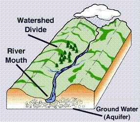
A watershed is a basin-like landform defined by highpoints and ridgelines that descend into lower elevations and stream valleys.
A watershed carries water "shed" from the land after rain falls and snow melts.

Drop by drop, water is channeled into soils, groundwaters, creeks, and streams, making its way to larger rivers and eventually the sea.
Water is a universal solvent, affected by all that it comes in contact with: the land it traverses, and the soils through which it travels.
The important thing about watersheds is: what we do on the land affects water quality for all communities living downstream.
In addition to posting a picture of your GPS at this location, please send an e-mail to the profile listed above with the answers to the following questions:
1) How many acres of land are in the Fish Pond watershed?
2) What parts of Letcher County are in a watershed?
3) If you poured out a glass of water at this location, what would happen to the water?
Please be careful not to disclose any answers in your pictures or posts.

This Earthcache was approved by the GSA

