Skip to content

Boulder Falls Traditional Geocache

This cache has been archived.

Ice and Wind: The cache owner has not responded to issues with this listing, so I must regretfully archive it. If the issues with this cache are resolved in the very near future (less than 3 months) the cache owner can email me and assuming the cache still meets the guidelines I can unarchive it.

Ice and Wind
Geocaching.com Volunteer Reviewer

More
Hidden : 5/22/2004
Difficulty:
2 out of 5
Terrain:
2.5 out of 5

Size: Size:   regular (regular)

Join now to view geocache location details. It's free!

Watch

How Geocaching Works

Related Web Page

Please note Use of geocaching.com services is subject to the terms and conditions in our disclaimer.

Geocache Description:

A short hike to a beautiful waterfall in one of the last lowland stands of intact virgin forest left in Washington.

Trailhead location: N 48° 15.063', W 121° 49.027'


Falls

The Boulder River travels through an area left alone decades ago by loggers, who deemed it too small a sliver of forest to be profitable. Today it is a lush wonderland of mossy giants, sword ferns, roaring rapids and wispy waterfalls.

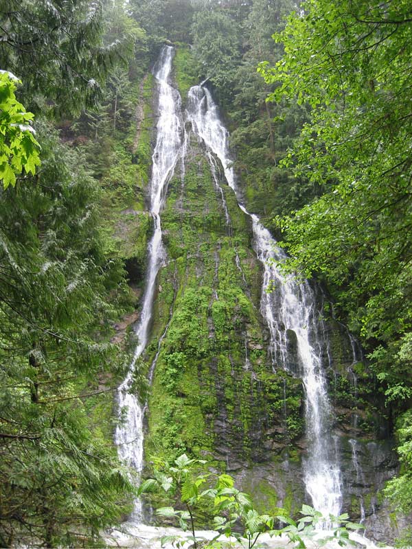
This cache will take you to one of the main attractions along the trails, Boulder Falls. In truth, the falls located here are unnamed - the real Boulder Falls are not visible from the trail and are about a quarter-mile downstream. However, these falls are spectacular, forming a veil split into two tails as they tumble down the steep walls of the canyon.

GPS reception in this canyon can be tricky, so be prepared to experience challenging signal. The hint should enable you to zero in on the cache once you get close. There is no bushwhacking necessary to get to the cache. The container is a transparent Lock-and-Lock box.

After stopping here, you should continue on down the trail to the Boulder River cache.

DOWNLOADS:
3D MAP FILE DESCRIPTION
Boulder_River_Trail.jpg Large map of the trail from trailhead to river crossing
Boulder_River_Trail_s.jpg Smaller map of the trail (ready for printing from browser)
Boulder_River_Trail-EasyGPS.loc EasyGPS file containing waypoints and track
Boulder_River_Trail-MapSource.mps Garmin MapSource file containing waypoints and track

Additional Hints (Decrypt)

Ubyybj va gerr onfr. Ybbx sbe ebpx cynprq ng ubyybj bcravat.

Decryption Key

A|B|C|D|E|F|G|H|I|J|K|L|M
-------------------------
N|O|P|Q|R|S|T|U|V|W|X|Y|Z

(letter above equals below, and vice versa)