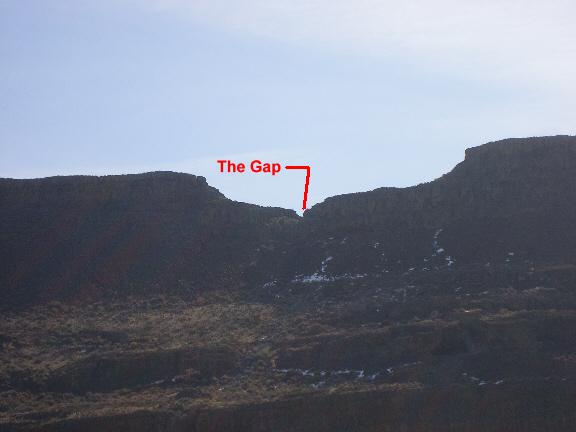
The hike starts at the Lenore Caves parking lot, elevation 1150
feet. When exiting Hiway 17 onto the dirt road that leads to the
parking area, if you look due east and upwards to the top of the
ridge, you will see a gap in the wall (shown in photo). That is
your destination. It's a scramble up approximately 400 feet
elevation gain, through sage brush and rock fields to "The Gap".
When you pass through the gap in the basalt cliff, you will be
rewarded with a view of a large coulee that runs north-south. This
coulee is only seen by the few who hike to this elevation, or by
looking down from an airplane. There are no roads, no sign of
modern man. In fact it actually looks like it may have looked a
million years ago...like time stood still.
In the valley floor of this large coulee, is a cross hatching of
smaller coulees. These smaller coulees have been appropriately
named "The Maze". If you were to hike down into the coulee and
across to the other side (an additional 3/4 mile past this cache),
there is a large boulder decorated with ancient man's petroglyphs.
Click Here for for an article with
photos of the petroglyph from spokaneoutdoors.com
UPDATE: There is now a geocache at the PETROGLYPH
This hike was given a 4-star terrain rating due to a fairly
steep trail which makes its way up to the gap. You will also need
to do a bit of scrambling over some large boulders. But the site on
the other side makes the hike well worth the effort. I wouldn't
recommend bringing small kids along on this hike. And here are some
warnings:
1) This is snake country. Please be extra cautious as you may
encounter one during the warm months. (Actually now - March - is a
great time to go).
2) Wear good hiking boots. Hiking through the rock field could
cause an ankle bender if you're not careful.
3) Be careful where you walk on the other side of the gap as
there are ledges and cliffs.
4) Be sure to bring plenty of water.

Route:
Start at the Parking Area which is the trailhead to the Lake
Lenore Caves. Head SW toward the caves. There is a cache there
called Lenore Caves Cache
by Mr. Gadget #2. If you haven't seen the Lenore caves or
visited the cache there yet, I highly recommend it. From the
Lenore Caves, you can proceed in a NE direction and tie into the
trail to "The Gap". If you've already found the Lenore Caves
Cache, then head left at Waypoint W1 and hike in a SE direction
up the trail, through "The Gap", find the cache.
Additional Warnings:
1) Cougar have been spotted in this area. It
is advisable not to hike alone and always be aware.
2)This is also rattlesnake country so watch
where you step or reach your hands.
3) The land down below in the coulee is open
land for cattle grazing. Please give wide berth to any cattle you
may encounter.
4) For your safety and to coexist with another
popular sport, please refrain from going into the coulee during
hunting season which runs from September 1st until the end of
November.
5) The land between this cache and the
petroglyph cache and to the North as far as Mr. Gadget's Lk Land of
the Lost cache is public land. Please limit your journey to these
caches only. There is privately owned land about 1/4 mile South of
the petroglyph, and private land just to the north of Mr. Gadget's
cache. These areas are not posted, but they are known to be private
property, so please keep out of those areas.