
There is no need to stray from any of the footpaths nor should any attempt be made to cross safety railings.
This cache is one of a trilogy of EarthCaches introducing three of the great landowning families of the late 18th and early 19th Centuries in Mid-Cornwall. The Treffrys, the Rashleighs and the Hawkins. They each played an enormous part in the development of mining in Cornwall and in particular the development of transport links in South Cornwall. They also left their mark on the Mid-Cornwall coastline with the development of Newquay, Par, Charlestown and Pentewan Harbours.
The other Earthcaches in the series are 'Cornwall's Mining Heritage - Charlestown Harbour'(GC1199G) and 'Cornwall's Mining Heritage - Pentewan Harbour'(GC11F8K)
The Luxulyan Valley is one of the most beautiful valleys in Cornwall. Now a haven for flora and fauna, it was formally one of Cornwall’s most important industrial (mining) sites. It was developed by one of Cornwall’s most famous mining entrepreneurs who became known as “The King of Mid-Cornwall”. He was Joseph Thomas Austen (1782-1850) who changed his name to his mother’s maiden name in 1838 and it is by this name, Joseph Thomas Treffry, that he is better known and remembered.
Treffry inherited the Treffry estates and was a major shareholder in the 5 mines (Wheal Treasure; Wheal Fortune; Wheal Chance; Wheal Polharmon and Wheal Lanescot) making up Fowey Consols (Cornwalls fourth richest copper ore mine) He developed the Luxulyan Valley initially (1820) to carry water to the mines. He later developed a series of leats (water courses) and tramways to link the quarries, mines and clay-pits to his new harbour at Par (1.5 miles to the South and completed in 1829). After his death further development in the valley saw new railways and tramways built, mainly associated with the clay industry and granite quarrying and linking Par harbour to the harbour at Newquay on the North coast. Relics of all these activities have been preserved throughout the valley and this earthcache will take you to some of the more important relics. There is, however, a wealth of other evidence of the Valley’s past for the visitor to discover. To log this earthcache you must visit each of the 3 sites mentioned below and answer a question. At one or more of the sites you are required to take a photograph (of yourself or your GPSr with) the relic visible in the background, include the photo with your log. Once you have found the answers to each of the questions A, B and C, email your answers to me using this link or via the profile.
New EarthCache guidelines 2010
Under the new guidelines, a photograph can be requested but specific detail cannot be required. Consequently your photograph can be just a general photo of the site. However a personal touch such as your GPSr (or yourself/member of your team!) in the photo makes it much more interesting.
Please email me your answers and then log the cache and include your photograph. I will review your answers and if there is any problem I will contact you to agree a course of action.
A) Waypoint V1, View of Viaduct N50° 22.971 W004° 44.070.
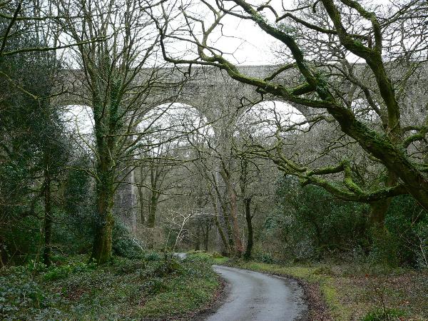
The best-known and largest (650ft. long and 98ft. high) relic in the Valley is the Treffry Viaduct. The viaduct (technically an ‘aqua-viaduct’ and now a Scheduled Monument and part of the Cornish Mining World Heritage Site) was built between 1839 and 1842 as a viaduct carrying a horse drawn tramway and an aqueduct carrying water to power Carmears Water Wheel. Although Treffry’s idea, a lot of credit for its design and construction is due to William Pease, Treffry’s steward. It was constructed using some 200,000 cubic feet of locally quarried granite (weighing nearly 20,000 tons) by local masons. Look for the Treffry coat of arms high up on the Northern side of the central pier.
Question A – how many arches are there in the total length of the viaduct?
B) Waypoint V2, View of remains of waterwheel N50° 22.693 W004° 43.240.
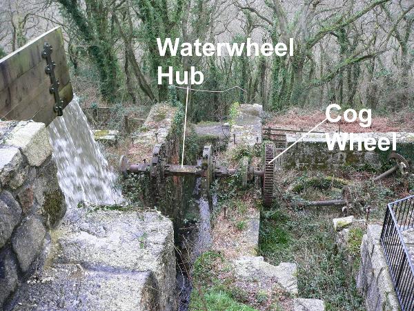
Carmears Wheelpit.
Until the development of steam engines, water was the principle source of power for most of Cornwall’s industry and this enormous wheelpit was designed and built to provide the power to pull wagons 325ft. up the 1 in 7 incline from the valley floor to the higher tramway. The wheelpit was constructed to hold a 50ft. diameter, overshot waterwheel but the first wheel was, in fact,only a 34ft. wheel. In 1872 a consortium of businessmen formed the ‘Cornwall Minerals Railway’ and started to develop a new route (now part of the Par-Newquay branch line) through the valley. In 1874 the use of the incline was abandoned, but with the waterpower still available, china stone grinding mills were built on either side of the wheelpit. The West of England China Clay Company, which built the mills, replaced the original waterwheel with a 40ft wheel and it continued running until 1908. It remained until 1940 when it was demolished and with the hub still in place, parts of the wheel are lying around the site.
Question B – Attached to the remains of the waterwheel hub is a cast iron cogwheel (transmission gear). How many spokes are cast into this wheel?
C) Waypoint V3, View of remains of Trevanney Dry N50° 22.463 W004° 43.237.
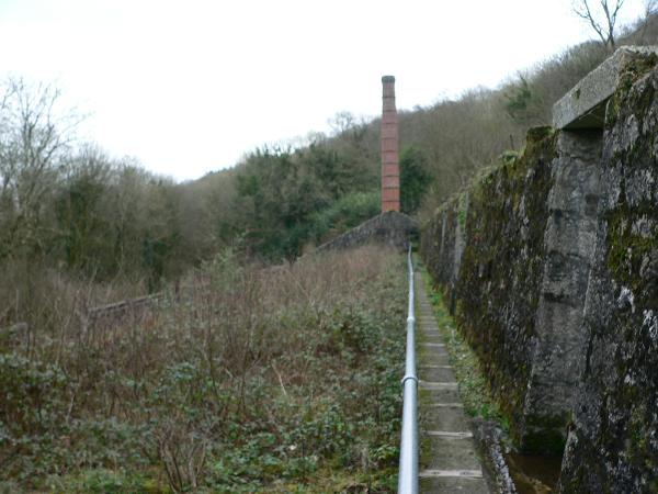
A more modern relic of the china clay industry, which succeeded the tin and copper mining industry in the valley, is the Trevanney Dry (clay drying kiln). Built in 1920 by the Central Cornwall China Clay Company, the dry was originally known as the Central Cornwall Clay Dry. It was a coal fired ‘pan-kiln’ used to dry liquid china clay slurry. China clay was (and still is) extracted by water action and the clay (in suspension) had to be dried before it was exported. Originally (before 1850) the clay slurry was air-dried but the introduction of pan-kilns considerably speed up the process. A pan kiln consists of a tiled floor (pan) heated by under floor flues. Hot air from a furnace at one end of the pan was drawn along the flues to a stack at the other end. The dry clay was cut into blocks for transporting by carts or railway wagons to the potteries or paper manufacturers. The clay slurry dried here at Trevanney Dry came (by pipe) from clay works on Hensbarrow Moor (North of St. Austell) some 5 miles away. Trevanney Dry continued working until 1965.
Question C – Using your GPSr, measure the length of the drying pan flues (i.e.the distance from the furnaces to the stack). To do this, make a waypoint at either the stack or the remains of the furnaces, walk to the other end and note how far it is to the waypoint you have just made.

| |
 |