
This cache is one of a trilogy of EarthCaches introducing three of the great landowning families of the late 18th and early 19th Centuries in Mid-Cornwall. The Treffrys, the Rashleighs and the Hawkins. They each played an enormous part in the development of mining in Cornwall and in particular the development of transport links in South Cornwall. They also left their mark on the Mid-Cornwall coastline with the development of Newquay, Par, Charlestown and Pentewan Harbours.
The other EarthCaches in the series are 'Cornwall's Mining Heritage - Luxulyan Valley'(GC116DV) and 'Cornwall's Mining Heritage - Pentewan Harbour'(GC11F8K)
At first glance the visiting geocacher might ask “Why is this picturesque little fishing harbour listed as part of Cornwall’s Mining Heritage?” The purpose of this EarthCache is to encourage you to look a little further than the piles of crab and lobster pots and discover the real reason for Charlestown’s existence.
It is true to say that at the end of the 18th Century, Charlestown was a fishing hamlet with less than a dozen inhabitants. However it wasn’t known as Charlestown, but West Polmear. East Polmear existed on the other side of St. Austell Bay, east of Par (on the way to Fowey and Polkerris).
At the end of the 18th Century, the mining of copper and tin ore and clay extraction was booming in the Mid-Cornwall area. This led to the great land owning families in the area to develop their land to take advantage of the boom. Joseph Thomas Treffry developed the Luxulyan Valley and Par Harbour to the East of St. Austell whilst Charles Rashleigh (1747-1825) developed East Polmear to the South of St. Austell. Thus mining and clay extraction have had a far-reaching effect on many aspects of the Cornish landscape.
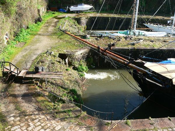
Charles Rashleigh was a local mining entrepreneur and industrialist who commissioned the foremost civil engineer of the day - John Smeaton FRS (1724-92) (who built the third Eddystone lighthouse) to build a harbour at West Polmear. Work started in 1792 (the year Smeaton died) and the harbour was finished in 1799. West Polmear was renamed “Charles’ Town” in honour of Charles Rashleigh. The work involved the construction of a breakwater, an outer harbour, an inner wet dock, and a seven-mile leat to bring water from the Luxulyan Valley. All these features remain today, although water is now pumped into the wet dock from the sea when conditions are dry (the leat is not maintained along all its length). In its heyday the harbour was home to a variety of industries connected with sailing ships, fishing but most importantly the export of copper ore and clay, and the import of coal and wood. A good start for further reading can be found here.
The waypoint given is for the Wet Dock gates, just a short walk from the public car park North of the harbour (charges applicable). As you walk down past the wet dock, look for the water entering the dock at the North end. This water comes from reservoirs further North and not only keeps the wet dock full at low tides but also helps to scour the passage out through the outer harbour. Then as you walk down towards the outer harbour, look at the far (eastern) side of the dock where you will see a folding chute. This is a 20th Century addition, which was used to enable clay lorries to tip their load of dry clay from the upper road into the holds of coasters in the dock. Further south, in the eastern wall of the wet dock, you will see a series of chute exits from hoppers or ore hutches, built into the east wall of the dock. The entrances to these hutches can be found on the side of the upper road above the east wall of the dock, covered with steel plates.
Because of its limited size and because ships can only enter the wet dock at the upper end of the tide, Charlestown’s harbour gradually became superseded by the deep water port of Fowey and the Treffry Harbour at Par in the latter part of the 20th Century. It is now home to “Square Sail” a company that owns a fleet of tall ships, used to make films all over the world. Occasionally the port is used as a film set and at such times, access may be limited. It should however be possible to obtain the answers required for this earthcache at all times,
To log this EarthCache you must visit Charlestown. You are also asked to photograph of (yourself or your GPSr with) a recognisable part of the harbour in the background and include the photograph with your log. You must also answer three questions and email your answers to me using this link or via the profile. If you are unable to provide a photograph I will accept a waypoint (+/-0.005) taken under the sign of the building in question C).
New EarthCache guidelines 2010
Under the new guidelines, a photograph can be requested but specific detail cannot be required. Consequently your photograph can be just a general photo of the site. However a personal touch such as your GPSr (or yourself/member of your team!) in the photo makes it much more interesting. To log this cache you may submit the co-ordinates for the ‘Building sign'’ instead of a photograph, as stated in the notes, but a photograph will eliminate the need for this measurement (and the risk of being outside the +/- .005’ limits)
Please email me your answers and then log the cache and include your photograph. I will review your answers and if there is any problem I will contact you to agree a course of action.
A) Waypoint C1 - N50° 19.872 W004° 45.388
Question A) What is the length of the wet dock? To measure its length, stand on the road, in line with the Northern end of the dock, where the water enters (see picture above). Using the waypoint given, which is for the wet dock gates, note how far away the waypoint is and this will give the length of the dock.
B) Waypoint C2 - N50° 19.912 W004° 45.390
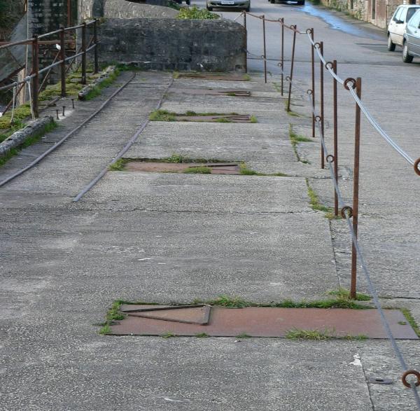
Question B) How many ore hutches are built into the east wall of the wet dock? (Count the number of steel plates (as shown above) on the side of the upper east road (Quay Road))
C) - No Waypoint.
Question C) Find a building in the village of Charlestown which bears the name of Charles Rashleigh – you might want to stop here for refreshments!! What is its name?
Pub Quiz Trivia
It is claimed by local residents that the road from St. Austell to Charlestown (Charlestown Road) was the first piece of purpose built ‘dual-carriageway’ (i.e. road built to carry two vehicles side by side in each direction) in Britain. I have been unable to find written confirmation of this but if any cacher can shed any further light on the subject, please email me via the profile. 
| |
 |