Llyn
Mwyngil (Talyllyn Lake), South
Snowdonia
This lake is a bit different from many of the other lakes in the
area. Yes it’s
wet & cold, yes it has fish in (or a lot of fishermen are
wasting their time!) and it’s in a U-shaped glacier carved
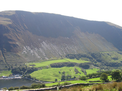
valley. But, Llyn Mwyngil is the result of what geomorphologists call
a “mass movement”. Sometime after the end of the last
ice-age, there was a gigantic landslide on the south side of the
Dysynni valley. This
left the hollow and the vegetated crag called Graig Goch. The debris dammed the valley,
trapping Llyn Mwyngil behind
it. The technical name
for the debris is a “solifluxion
lobe”. From the
earthcache site, you can see how the
volume of material would exactly fit back into the cwm
above.
I was first introduced to the reason why Llyn Mwyngil is there whilst accompanying an A-level
geography field trip from work. I’m told that this is one of
the classic examples of mass movement in Britain (but I’m not
a geographer, so I’m not an expert!).
To get to the cache, it is possible to park on the north side of
the lake (see waypoint), leaving you with a short walk along tarmac
before the steep uphill Public Footpath. On the way, you’ll pass
Sam’s cache by The Nuggets (GCNVV4),
which is set in a beautiful place and worth stopping to look
for. Alternatively, you
could come from the carpark at
Llanfihangel-y-Pennant, via the Dysynni
Squeezeboxers’ cache at Carreg
Ewnau (GCP799).
To
qualify for this cache, please attach a photo of your GPS (or
rucksack) on the stile that I stood on to take the photo at the top
of this text. Using the view from the cache and your map, can you
estimate the area covered by the landslide? (not all of it is in my photo!)