
 The Tujunga Wash is a significant drainage of the San Gabriel Mountains. These mountains are relatively young and are continuing to grow. They are also tall enough to create a rain shadow (See San Jacinto Mountain) and receive more than twice as much precipitation as the coastal plains and valleys. One of the results of this combination is that the streams that drain the mountain are steep and fast and thus highly erosive. The size and quantity of sediment a stream can carry is proportional to the speed of the water.
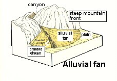 While up in the mountains, Tujunga Wash is constrained by the sides of the canyons. Short intense winter storms generate heavy rainfall at elevation creating pulses of fast flowing runnoff that are heavily sediment laden. When Tujunga Wash leaves the mountains and the constraints of the bedrock valleys and enters the valley, the slope of the river channel decreases which slows the water down.
The slower water no longer has the capacity to carry as much sediment, so the stream begins to deposit the material it was carrying. The largest particles are the first to stop being moved. As the storm runoff begins to subside, the sediment that was deposited blocks portions of the water flow. The stream begins to split and reform in random patters to find a way around the deposited material forming a braided channel. Braided stream channels typically form in water courses where there is more sediment than the water has capacity to carry. During times of little flow, the water in Tujunga may be in a single channel. But you can find multiple channels where water would flow around small islands.
Often the main channel is scoured vertically down though previously deposited sediment. You can examine the size of the particles and observe some layering based on grain size.
Flash Floods are a danger in the area. The mountains may be receiving heavy rain even if there is no rain in the area. Water may suddenly begin flowing down the river channel with little or no warning.
Logging requirements (Use the High Flow coordinates (N34 16.338 W118 20.284)during times of high water flow or when rain may be predicted in the mountains).
Send me a note with :
- The text "GC17CFG Tujunga Wash – Alluvial Fan and Braided Stream" on the first line
- The number of people in your group.
- From the coordinates and the secondary coordinates (N34 16.249 W 118 21.054) count how many different channels you can see, remember some may be currently dry. Consider where water would flow if the water was 5 or 10 feet deep.
- Examine the sides of the scoured channel (N34 16.202 W118 21.011). Describe the size and shape of the grains. Is there any layering you can see?
- Look at the sides of the channel down stream of the bridge (N34 16.249 W 118 21.054). Describe how it changes and what happens to the width of the channel.
Additional Info: In 1969, a gravel pit was located about 3000 feet down stream of the bridges. During the floods, water began flowing into the pit eroding the side of it like a water fall. Erosion continued back up stream undermining the foundations of the bridge collapsing it.
The above information was compiled from the following sources:
- Kevin M. Scott. Scour and Fill in Tujunga Wash A Fanhead Valley in Urban Southern California 1969. Geological Survey Professional Paper 732-B