There are five such courses in Edinburgh, and I have placed caches at each of them:
Note that the last cache (Cammo Estate) is a bonus cache that can only be completed once you have done the other four!
Orienteering
Orienteering is a sport involving navigation between control points (controls) marked on a map. The challenge is deciding the best route between controls and trying to complete the course in the quickest possible time. Orienteering events take place most weekends if you are prepared to travel a bit. They range from small "come and try it" events held in local parks, right up to large multi-day events attracting 1000s of competitors from all over the world! Courses are usually set by age and ability, but smaller events may simply use colours to grade the courses (white, yellow, orange, green, blue ... etc). Either way there is usually a course for everyone.
More information can be obtained from The Scottish Orienteering Association or from one of the two Edinburgh-based orienteering clubs: Edinburgh Southern Orienteering Club and Interlopers. Or feel free to contact me via my profile!
Maps
You don't actually need proper maps to complete any of these caches, however if you would like detailed maps of the areas, you can buy them as follows:
- Hillend and Bonaly: Pentland Hills Regional Park Office at Boghall on the A702 during normal working hours (phone 0131 4453383 to check), or from the Hillend Ski Centre during its opening hours. The Bonaly map can (usually) be obtained at a slightly higher price from the Bonaly Corner Shop (corner of Bonaly Road and Bonaly Avenue). I say usually because when I checked, they had run out!
- Blackford Hill and The Hermitage, Corstorphine Hill and Cammo Estate: The Hermitage of Braid Visitor Centre or Cammo Lodge Visitor Centre, both normally open from 2-4pm on weekdays (phone 0131 4477145 to check)
Alternatively, maps can be obtained from Edinburgh Southern Orienteering Club, or contact me and I'll pass on more specific details of how to get them.
Compasses and Bearings
Unlike the cache at Hillend, parts of this cache require that you follow route descriptions, which may include distances and bearings. You will therefore need a compass and know how to use it. Personally I find a compass easier and more reliable than a GPS as its not dependent on satellite coverage.
Most compasses have a large baseplate with an arrow, a rotating housing with numbers and a magnetic pointer where the red end points north (unless the polarity has been reversed, which can happen if you put it through an xray machine!). Taking a bearing is pretty simple really:
- rotate the housing until the desired number (i.e. bearing) lines up with the baseplate arrow
- keeping the compass flat, turn around until the red magnetic pointer lines up with N (north) on the rotating housing (usually the housing itself has an arrow to make this easier)
- walk in the direction of the baseplate arrow, keeping the red magnetic pointer and N (north) on the housing aligned at all times
In orienteering, all bearings are magnetic as the maps used have north lines which point to magnetic north!
The Cache
This cache is at Corstorphine Hill (a contender for the muddiest place on earth ??) and the co-ordinates above are your starting point, the end of the road/start of a large path. There is ample parking on the streets nearby.
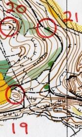
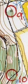
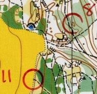
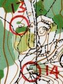
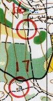
The course I've set involves visiting the following controls in order: 19, 21, 10, 9, 8, 11, 13 and 14. At each control there will be a red and silver marker, usually attached to a post (see example). The marker will show the control number (19, 21, 10 ... etc) together with a single letter/code. Check that you've found the right one (using the control number), make a note of the letter and then convert it into a number using the formula A=1, B=2, ..., Z=26.
Note that this cache is a bit different to the others in the series. There are no waypoints at all (making it a puzzle cache), and instead of providing written route descriptions, some controls will require a bit of map reading instead! To do this I've included small sections of the Corstorphine Hill orienteering map (all are copyright Edinburgh Southern Orienteering Club, 2002). Many thanks to Janet Clark from ESOC for her kind permission to do this! All the map sections are aligned on the printed page such that north is at the top, and a key to the symbols used can be found here. The main difference from other maps is that white represents open forest! All the maps are scanned at the same resolution, and a rough scale is that the direct distance between controls 19 and 21 is 180m. Finally note that the first map includes an extra control, number 20. Please ignore this as its not on your course!
The following table describes the course:
| Control Number |
Description |
Route |
Letter/Code |
Convert using A=1, B=2 ... etc |
| 19 |
Hill top |
From the start head along the large path on a bearing of 82 degrees. After 150m there is a path heading up to the clearing on left - ignore this and continue on for a further 120m, passing crags on your right. As the main path turns 90 degrees to the left, head up the smaller path on a bearing of 300 degrees. Just before the clearing ahead there is a small vegetated hill on your right. The control is on the top and is well hidden. |
|
|
| 21 |
Small thicket |
 |
|
|
| 10 |
Boulder |
Continue along the main path for 280m until you get to a distinctive boulder on your right. Continue on, down hill and round a large bend to the right. At the path junction turn right and follow this down hill for 120m. The boulder is a short way off the path to your left. |
|
|
| 9 |
Ruin |
 |
|
|
| 8 |
Depression |
Head back to the main path, turn right and at the path junction look out for a small path heading steeply up hill on a bearing of 250 degrees. Follow this, keeping straight ahead at the fork, for 120m. As it levels off, keep left and after a further 50m you will reach a large path. Turn right and the depression is down to your right. |
|
|
| 11 |
Path end |
 |
|
|
| 13 |
Crag |
Head up the path on a bearing of 130 degrees, through the gorse, until you reach the path junction. Turn right and follow this for 60m. The control is at the foot of a crag 25m from the path to your right. |
|
|
| 14 |
W end of S crag |
 |
|
|
The cache is on the way back to your starting point, near one of the bonus cache controls (see below), but first you need to calculate its location. As a sanity check, the numbers you have worked out should add up to 118.
The cache can be found X metres on a bearing of Y degrees from the control whose letter/code is "Z", where
X = (value calculated from the letter at) control 10 + control 19
Y = (control 11 * control 13) + (control 21 * control 14) + control 9 + control 8 - X
Note that the symbol "*" means multiply. As a final check, both X and Y are divisible by 10 (exactly).
The cache is well hidden but the clue is a big help. Please make sure you put the cache back exactly as you found it.
Bonus Cache
To get back to the start (and find the cache on the way!), continue by visiting the following controls in order: 16, 17 and 18. Again at each control, double check you've found the right one (using the control number), make a note of the letter and then convert it into a number using the formula A=1, B=2, ..., Z=26:
| Control Number |
Description |
Route |
Letter/Code |
Convert using A=1, B=2 ... etc |
| 16 |
Path junction |
Due west of control 14 you will see a large path contouring round the hill to the west. Follow this, initially on a bearing of 230 degrees, right round the hill, for 200m. At the sharp right hand bend, keep to the path, up hill, passing a crag on your left. The path junction is immediately ahead, and the control is well hidden to your right. |
|
|
| 17 |
Small crag |
 |
|
|
| 18 |
E most crag |
From control 17 (which is well hidden in vegetation at the foot of a small crag), go to the path to the south, and follow this uphill for 30m, turning right, and then right again, until you are heading down a path on a bearing of 240 degrees. Follow this for 60m, and you will see a path to the left heading down into a small rocky valley. The control is by the first crags on the right. Note that the proper marker is missing from the post, but the number (18) and code are written on the post itself. |
|
|
As a sanity check, the numbers you have worked out should add up to 54. These values are required to complete the bonus cache: Edinburgh Orienteering Series: Cammo.
Good luck!