Machu Picchu Fault Line Earthcache
ENGLISH:
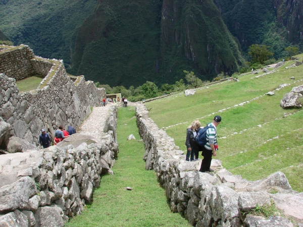
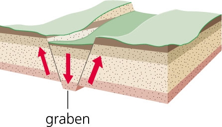
The Inca site Machu Picchu is built on a large wedge shaped fault block called a graben that was formed by a gradual subsidence downward of the block created by two parallel running faults, one near Machu Picchu and the other near Huayna Picchu. This, along with the erosion processes over the past several million years, created the familiar “two peaks with a saddle between“ topography that the Inca carefully selected for the most important of their sacred ceremonial centers.
The nearby Urubamba River contributed by carving a deep entrenched meander around the site as continuing tectonic forces slowly lift the mountain mass of the Andes. Numerous lesser faults and subsurface factures resulting from mountain building pressures are also present. As base rock is exposed by erosion, these fractures offer zones of weakness subject to ground water penetration and other surface forces that create fragmentation and disintegration into blocks and pieces and eventually into mixed mineral-organic residue soil. These loose boulders and rocks were the material that supplied building stone for Machu Picchu.
The regional mountain base is part of an uplifted Paleozoic era (250 million years old) intrusive igneous feature classified geological as a batholith. These are massive upward traveling bodies of molten material (magma) that penetrate the upper layers of the earth’s surface before stopping short of the surface. Upon cooling they typically leave a shield or stock shaped mass of igneous rock more than 40 square kilometers in area. Here, the rock type is mainly a resistant fine grained (small crystallized) white granite which proved excellent for hammering into finely shaped blocks and sharply defined angles.
Reference: Geological Society of America
________________________________________
In order to log this Earthcache, complete the following
tasks:
1.) What is the elevation difference between the posted cords and the child cords labeled as PT2 in the chart below (S 13° 09.888 W 072° 32.703)?
2.) How many millions of years old is the igneous features at this site?
3.) Not required, but it would be nice to post a picture of
yourself with your GPS, or just your GPS at this location.
4.) You can log this cache straight away after you have emailed your answers to the cache owner, no need to wait for confirmation.
______________________________________
SPANISH:
El Nuevo cables te lleve a la línea de falla de Machu Picchu.
El sitio inca de Machu Picchu está construido en un bloque de falla en forma de cuña grande llamado un graben que se formó por un hundimiento gradual a la baja del bloque creado por dos fallas paralelas, una cerca de Machu Picchu y la otra cerca de Huayna Picchu. Esto, junto con los procesos de erosión durante los últimos millones de años, creó el conocido "dos picos con una silla de montar entre" la topografía que el Inca cuidadosamente seleccionados por el más importante de sus centros ceremoniales sagrados.
El cercano río Urubamba aportados por la talla de un meandro arraigado profundamente en todo el sitio como la continuación de las fuerzas tectónicas levante lentamente la masa de la montaña de los Andes. Numerosas fallas y fracturas menores del subsuelo como resultado de presiones de formación de las montañas también están presentes. Como base de roca está expuesta por la erosión, estas fracturas ofrecen zonas de debilidad sujeto a la penetración de las aguas subterráneas y otras fuerzas de superficie que crean una fragmentación y desintegración en bloques y piezas y, finalmente, en mi jo minerales orgánicos residuos en el suelo. Estas rocas sueltas y rocas fueron el material que suministran edificio de piedra de Machu Picchu.
La base de la montaña regional es parte de un elevado era Paleozoica (250 millones de años) cuentan con ígneas intrusivas clasificados geológicas como un batolito. Estas son enormes cuerpos al alza de viaje de material fundido (magma) que penetran en las capas superiores de la superficie de la tierra antes de detenerse por debajo de la superficie. Al enfriarse se suele dejar un escudo o una masa de valores en forma de roca ígnea más de 40 kilómetros cuadrados de superficie. Aquí, el tipo de roca es principalmente una resistencia de grano fino (cristales pequeñostallized) de granito blanco que resultó ser excelente para martillar en bloques finamente en forma y bien definidos los ángulos.
Con el fin de registrar este Earthcache, realice las siguientes tareas:
1.) ¿Cuál es la diferencia de elevación entre las cuerdas y las cuerdas publicado niño (PT2 S 13° 09.888 W 072° 32.703)?
2.) ¿Cuántos millones de años de antigüedad son las características ígneas en este sitio?
3.) ¿No se requiere, pero que sería bueno para enviar una foto tuya con tu GPS o, simplemente, el GPS en este lugar.
4.) Puede iniciar sesión esta caché inmediatamente después de haber enviado por correo electrónico sus respuestas al propietario caché, no hay necesidad de esperar la confirmación.
________________________________________
Congratulations to:
FTF: Franklj, Australia
STF: Shaggz, Austria
TTF: Becka3315, USA