Tesny dul / Tight valley
czech
Cílem této cache je seznámit se s romantickou roklí mezi Černou horou a Světlou zvanou Těsný důl, neboli též Klausový důl.
Těsný, Klausový důl. : Důl se nachází v pohoří Krkonoše. Mezi Černou horou a Světlou . Údolím protéká Černohorský potok, který pramení v Černohorském rašeliništi. Údolí potoka je sestaveno ze dvou zhruba stejně dlouhých částí odlišného charakteru. Horní část / Těsný důl / vznikla na podloží tvrdých muskovitických ortorul a ještě tvrdších sericitických kvarcitů a metalyditů . Černohorský potok tu má velký spád (s 500 m při délce 3,1 km patří k vůbec nejvyšším v Krkonoších) a vytváří tu hluboké úzké horské údolí zaříznuté v podobě písmene V . Dolní část je tvořena měkčími fylity. Zmenšuje se sklon dna i hloubka údolí za jeho současného rozšíření, takže připomíná již spíše podhorské údolí .
Název Klausový důl nás odkazuje na termín klausa nebo též klauza, což je přehrada sloužící k plavení vytěženého dřeva z hor dolů do údolí, která zde v minulosti stávala.
Ortorula : Ortorula nebo řidčeji leukokratní rula je metamorfovaná hornina, která vznikla přeměnou kyselých až intermediárních vyvřelých hornin jako jsou granitoidy, granodiority, křemité diority a další, v amfibolitové facii. Jde o hrubo až středozrnné, výrazně břidličnaté horniny, ve kterých převládá křemen, biotit, muskovit, draselný živec, méně častý je plagioklas. Vedlejší minerály jsou granáty, kyanit, případně amfibol.
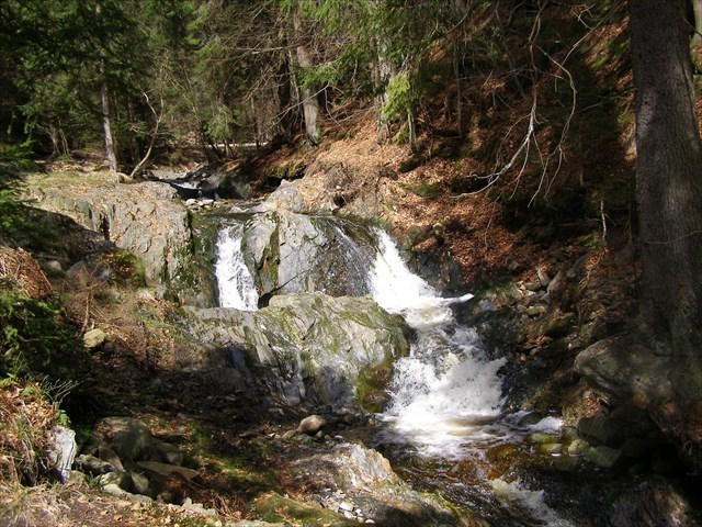
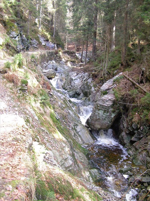
Vodopády: V horní polovině toku Černohorského potoka, v Těsném dole, se vyskytují četné vodopády. V úseku dlouhém 2,1 km se nachází celá série nerovností, z nichž dvanáct lze označit jako výraznější vodopádové stupně, anebo jejich soustavy. Vodopádové stupně jsou geneticky vesměs sekundární, ale bezprostřední příčiny vzniku jsou díky geologickému podloží rozdílné. Jednotlivé stupně na podloží muskovitických ortorul ve střední části údolí jsou podmíněné lokálními tektonickými poměry (výraznými puklinami a puklinovými zónami), zatímco poněkud delší soustavy na spodním konci jsou strukturní, na kontaktech různě tvrdých kvarcitů, metalyditů a fylitů. Jako nejosobitější stupeň Černohorského potoka zaslouží samostatné pojmenování Soutěskový vodopád. Jeho poloha je zaznačena na některých mapách.
Prameny: V horní polovině toku Černohorského potoka, v Těsném dole, se nacházejí také tři prameny. Směrem proti proudu potoka to jsou pramen Betty, Bukový a Lopuchový pramen. Prameny jsou zdrojem léčivé radioaktivní minerální vody.
Poklad: K uznání logu musíte navštívit tuto lokalitu a splnit následující úkoly cestou po Těsném dole.
Přístup k pokladu:
Přístup z Jánských Lázní. / waypoint 1 / Vás přivede ke vstupu do Těsného dolu. Dále pokračujeme Luisinou cestou. Ta je zčásti rekonstruovaná. Tato část ale končí dřevěnou uzávěrou. Pokud chceme pokračovat dále , musíme zde potok přebrodit / waypoint 4 / . Na druhé straně nás čeká pěšina, vedoucí proti proudu Černohorského potoka. Cestou mineme tři prameny. U třetího pramene / waypoint 2 / končí naše cesta Těsným dolem . Zde se musíme rozhodnout, jak budeme dále pokračovat. Můžeme přejít potok na druhou stranu a pokračovat po ceste až k Malým Pardubickým Boudám. Zde se napojíme na červenou turistickou značku. Nebo se u třetího pramene otočíme, vrátíme po stejné ceste zpět.
K uznání logu bude zapotřebí odpovědět na následující otázky a splnit úkoly:
1.Změřte nadmořskou výšku při vstupu do Těsného dolu / waypoint 1 / a při třetím prameni / waypoint 2 /. Vypočítejte jejich rozdíl.
2. Těsný důl je vytvořen v hornine ortorula. Z jakého názvu je odvozen termín rula?
3. Cestou Těsným dolem minete mnoho zajímavých skal. Jednotlivé minerály v hornině skal mají rovnoběžný proužkovitý vzhled. Co tento vzhled spůsobilo? Odhadněte, v jakém úhlu k cestě jsou uspořádány tyto jednotlivé proužky minerálů v hornině skály na / waypointu 3 /.
4. Skála na / waypointu 3 / je poznačena silným zvětráváním. Zjistěte, zda se na tomto místě jedná také o biologické zvětrávání.
5. Cestou Těsným dolem minete také tři zmiňované prameny. Zjistěte, který pramen je nejsilnější zdroj léčivé radioaktivní vody?
6. Dobrovolné: Zajímavé foto z lokality potěší.
Můžete se zalogovat hned. V případe, že neobdržím do 7 dní e-mail s odpověděmi na dané úkoly, váš log bude muset být vymazaný jako neplatný!
Nacházíte se v Krkonošském národním parku. Neopouštejte stezku. Při hledání není potřeba chodit ze stezky. Příroda Vám bude vděčna.
English
The purpose of this cache is to get acquainted with the romantic gulf between Černá hora and Světlá , called Tight Valley, or the Klaus Mine.
Tight, Klaus mine : The mine is located in the Krkonoše Mountains. Between Černá hora and Světlá . The creek flows through the valley, which originates in the Čerohorský peat bog. The stream valley is composed of two roughly equal parts of a different character. The upper part / Tight Mine / was formed on the subsoil of hard muscovite ortors and even harder seric quartzites and metalydites. The creek has a large creek (with 500 m at the height of 3.1 km it belongs to the highest in the Krkonoše Mountains) and creates the deep narrow mountain valley cut in the form of letter V. The lower part is made up of softer phyllites. The slope of the bottom and the depth of the valley are diminishing behind its current expansion, so it is more reminded of the valley below.
The name Klaus Mine refers to the term clause, or a clause, which is a dam used to float the harvested wood from the mountains down into the valley that was here in the past.
Ortorula: Ortorula or a leucocyte leucorrhea is a metamorphic rock formed by the transformation of acidic to intermediate burnt rocks such as granitoids, granodiorites, diamonds and others, in amphibolite faction. They are rough to medium-grained, highly shaley rocks with predominantly quartz, biotite, muscovite, potassium feldspar, less plagioclase. The secondary minerals are garnets, cyanide, or amphibol.
Waterfalls: There are numerous waterfalls in the upper half of the stream of the Černohorský brook, in the Těžný Mlýn. In a 2.1 km long stretch, there is a whole series of inequalities, twelve of which can be described as more significant waterfall stages, or their systems. The waterfall stages are genetically mostly secondary, but the root causes are different due to the geological background. The individual stages on the base of the muscovite orator in the central part of the valley are conditioned by local tectonic ratios (pronounced cracks and cracked zones), while somewhat longer systems at the lower end are structural, on contacts of various hard quarks, metalydites and phylits. As the most gracious level of the Černohorský brook deserves the unique name of the Conquering Waterfall. Its location is highlighted on some maps.
Streams: In the upper half of the Černohorský stream, in the Těsný důl, are also three streams. Moving on against the flow of the river there is the Betty stream and Bukový and Lopuchový stream. These streams are the source of the sanative radioactive mineral water.
Treasure: To recognize the log, you must visit this site and complete the following tasks by following the Tiny Bottom.
Treasure access: Access from Janske Lazne. / Waypoint 1 / will bring you to the Tail Mine. We continue along Luis' path. It is partially reconstructed. But this part ends with a wooden shutter. If we want to continue, we have to cross the stream here. On the other hand, there is a footpath leading upstream of Černohorský potok. On our way we can see three streams. The third stream / waypoint 2 / is the end of our trip through the Těsný důl. Here we have to decide how we will continue. We can cross the stream to the other side and continue along the way to the Little Pardubice Boudy. Here we connect to the red tourist sign. Or we turn around at the three stream and we go back along the same path.
To recognize the log, you will need to answer the following questions and accomplish the following tasks:
1. Measure the altitude when entering the Tank / waypoint 1 / and the three streams / waypoint 2 /. Calculate their difference.
2. Těsný důl is made of the mineral called ortorula. From which title came the term rula?
3. On the way through the Tall Woods, we have many interesting rocks. Individual minerals in rocks have a parallel stripe appearance. What caused this look? Guess in what angle to the road are arranged the mineral stripes of the rock at the / waypoint 3 /. .
4.The rock at / waypoint 3 / is marked by strong weathering. Find out if this is also about biological weathering.
5. On the way through the Těsný důl you can see three before mentioned streams. Find out, which stream is the biggest source of the sanative radioactive water..
6. Voluntary: Interesting photos from the site will delight.
You can log in now. If you do not receive a response email of up to 7 days, your log will have to be deleted as invalid!
You are in the Krkonoše Mountains National Park. Do not leave the trail. There is no need to walk out of the trail when searching. Nature will be grateful to you.