Cette cache n'est PAS aux COORDONNÉES PUBLIÉES. Pour trouver une cache mystère, une tâche doit être effectuée pour collecter les coordonnées finales! Toutes les informations nécessaires se trouvent le long du SENTIER entre Abondance et La Chapelle-d'Abondance. (A01-A16)
This cache is NOT at the POSTED COORDINATES. To find a Mystery Cache a task needs to be done to collect the final coordinates! All required information can found along the TRAIL between Abondance and La Chapelle-d' Abondance. (A01-A16)
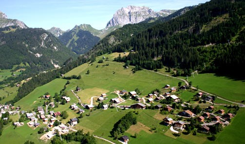
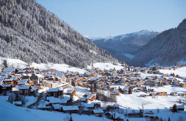
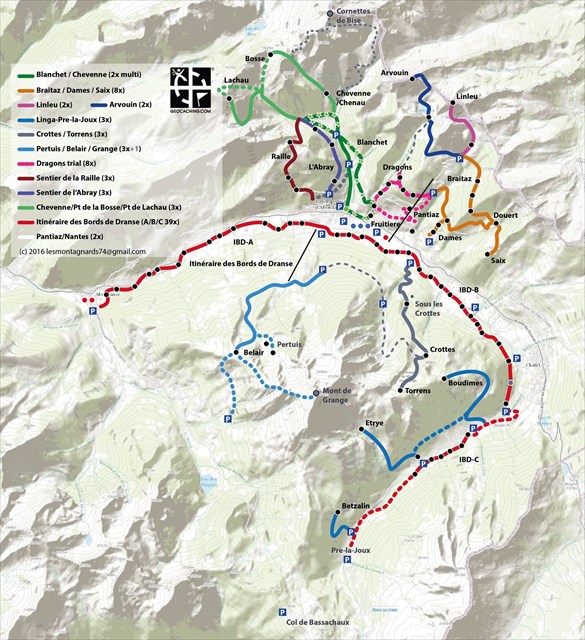
[F] Cette cache est part d'une série. La série offre une puissance sentier le long de la «Itinéraire des Bords de Dranse" : un parcours pour la randonnée, le vélo ou le ski de fond d'Abondance (aujourd’ui) jusqu'à Chatel-Linga (prévus jusqu'à Pré-la-Joux). Le sentier est composé par le Project ‘Itinéraire des Bords de Dranse’ de la Val d’Abondance. Le sentier etais complété en 2014.
La route geocaching se compose de trois parties: [1] Première partie: Abondance - La Chapelle [IBD#A + bonus]; [2] Deuxième partie: La Chapelle - Châtel (Linga) [IBD#B sans bonus]; [3] Troisième partie: Châtel (Linga)-Pré-la-Joux [IBD#C + bonus].
Les caches traditionnels sont placés le long du sentier (38). Mystery Caches sont ajoutés sur le début et en remplissant les parties (A), (B) et (C): 'Depart', 'En Route' et BONUS-A (Trouver XXX et YYY dans A01-A16), BONUS-C. Les cache traditionnels sont de type 'Petling' et contiennent un petit carnet. S'il vous plaît retourner tous les contenus, fermer les correctement et placez les caches au même endroit.
[EN] This cache is part of a series. The series offers a power-trail along the “Itinéraire des Bords de Dranse”, a route for hiking, biking or cross-country skiing from Abondance via Chatel-Linga until Pré-la-Joux. The route is facilitated by Val-d’Abondance, project team ‘Itinéraire des Bords de Dranse’. The track was completed in 2014.
The traditional caches are placed along this track. EXTRA 'Unknown' caches are placed on the start, end and along the trails (A), (B) and (C). TWO bonus caches are available: BONUS-A (A01-A16: find XXX and YYY) and BONUS-C (C01-C05). The regular caches are of the 'Petling' type - small containers containing a log book. Please return all the contents, close them correctly and place the caches on the same spot.
The track can be distinguished into three parts. [1] One : Abondance - La Chapelle [IBD#A]; [2] Two : La Chapelle - Châtel-Linga [IBD#B]; [3] Three: Châtel (Linga)-Pré-la-Joux [IBD#C]. Traditional caches (38) are placed along the track.
CACHE
Pour trouver la cache, on doit collecter d'information le long la route. Un GPS est nécessaire. Soyez conscient que les équipements GPS est loin d'être exacte dans les zones de montagne. Utiliser spoiler et indices! boîte à vin (bois). Remarque: La boîte n'est pas directement cachée sur la piste. Un petit detour!
To find this cache, you need to collect information along the trail. A GPS is required. Be aware that GPS equipment is far from accurate in mountain areas. Use spoiler and hints! Wooden Wine Bottle box. Note: The box is hidden off the trail. A short detour is necessary.
SERIES:
traditionals: IBD#A01-16 / B01-16 / C01-05
mysteries: IBD#START, ENROUTE_A, ENROUTE_B, IBD#BONUS_A, IBD#BONUS_C
this cache: BONUS_A (trouver XXX et YYY en route!)
COORDS N 46° 17.XXX' E 6° 48.YYY'

You can validate your puzzle solution with
certitude.
Après finir les étapes on peut placer une bannière sur la profile.


LOG - You have found a unique cache which the CO has spend a lot of time for to prepare and maintain. Respect Geocaching, consider leaving more then ‘T4TC’ or ‘MPLC’. Please add additional information which is useful for the next geocacher, ie local conditions, conditions of the cache, experience during the tour which does not reveal the location. Thank you!
[F]Gardez à l'esprit que la précision minimale d'un dispositif GPS standard est dans des situations optimales pas moins de 3 mètres. Dans le cas des arbres, des montagnes, des bâtiments ou mauvais alignement de la constellation de satellites c'est facilement 15-30 mètres .... les caches ont été calculées sur la base de 6 pistes, recueillies par 2 appareils GPS différents sur 3 jours différents en 3 semaines différentes. Environ une semaine après l'activation des caches les coordonnées ont été vérifiés en utilisant 2 appareils GPS (Montana 600 et MAP62). Seulement ° 13 avait une irrégularité dont nous n'avons pas encore corrigé et a été confirmée par Jab23.
[EN]Keep in mind that the minimum accuracy of a standard GPS device is in optimal situations no less than 3 meters. In case of trees, mountains, buildings or bad alignment of satellite constellation this is easily 15-30 meters.... the caches have been calculated based on 6 tracks, collected by 2 different GPS devices on 3 different days in 3 different weeks. About one week after activating the caches the coordinates have been checked using 2 GPS devices (Montana 600 and MAP62).
Cette cache a été selecté pour le 2016 Geocaching Concours du Val-d'Abondance / This cache is selected for the 2016 Geocaching Concours in Val-d'Abondance [GCCVA16].