Petersfield Past and Present (Hampshire) Multi-Cache
PetersfieldPoodlePosse: This cache has now been archived and replaced with a new cache GC1MBWD Petersfield Past and Present (2009)
Petersfield Past and Present (Hampshire)
Please note Use of geocaching.com services is subject to the terms and conditions
in our disclaimer.
A cache in and around the historical market town of Petersfield in
North East Hampshire. The route will lead you through the town
centre taking in some of the “sights” both past and present. The
co-ordinates above are for the War Memorial at the eastern end of
the High Street.
|
Whilst the walk around
the town is suitable for pushchairs and wheelchairs, unfortunately
the last 100 metres or so are not.
The town has been referred to as Eatersfield due to the number of
restaurants and particularly coffee shops that have opened
recently. There are plenty of traditional hostelries as well to
quench your thirst or have a bite to eat, many of which owe their
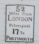
historical roots to Petersfield’s former status as a coaching stop
between London and Portsmouth; indeed you will have to at the very
least walk past half a dozen public houses to complete the
cache.
There are plenty of car parks in Petersfield but they are generally
expensive and can be busy (especially on Wednesday and Saturday
when the market is held in The Square).Co-ordinates for two car
parks are given in the waypoints below;the Festival Hall is closest
to the start of the route but you will have to pay (at the time of
setting the cache 30p an hour or 70p for two – an hour may not be
enough); Love Lane is closer to the final cache location and is
free.
Finally it will be beneficial to Google a number of the more
obscure clues before setting off! |

|
The Clues
Leave the Festival Hall car park by walking past the hall itself
and out onto Heath Road (south side of car park).
As you walk west along Heath Road find the year in which the
building where The Earl of Selborne’s Own meet was constructed
ABCD
When you reach the end of Heath Road turn north and find the year
in which the railway first came to Petersfield EFGH
Once you have these two dates cross the road and continue west up
the High Street.
Next you are looking for a location with a fairly scientific name
which was given by a Major and opened by a royal dignitary.
Take a note of the last letter in the Major’s surname; you will be
instructed to travel in that direction later.
The royal dignitary has a similar title to William Earl of
Gloucester, who during the reign of Henry II granted a charter for
the founding of Petersfield as a borough originally named
Peterfelde.
Continue westward until you reach The Square where you will see the
statue of William of Orange on his horse with St. Peters church
behind.
This is the only statue of William in a town square in the United
Kingdom outside Northern Ireland and commemorates William's victory
at the Battle of the Boyne.
| Sir William Jolliffe, M.P. for Petersfield, a great
admirer of William as the 'avenger of liberty' left a minimum sum
of £50 in his will in March 1750 for the purchase of an equestrian
statue of William to be erected in Petersfield. The statue stood
first in the courtyard of Petersfield House, which was for over
sixty years the seat of the Jolliffe family in Petersfield, and it
was not until its demolition in 1793 that it was removed to its
present position. |

|
At one time both the horse and the rider were gilded, and the
former Golden Horse Inn, previously on the east side of the square,
owed its name to the fact.
More recently, the statue was restored and unveiled in 1913 by the
2nd Earl of Selborne, William Waldegrave
Which ordinal number is associated with William of Orange?
Answer = J |
Continue to the westward end of the High Street, where you will
find a timber framed, white walled building where cooking regularly
takes place. This former farmhouse is reputed to be one of the
oldest remaining buildings in the town dating from the sixteenth
century and has survived a fire in modern times.
Can you find a more accurate date? 15KL
Turn the corner at the travel agents into Chapel Street.
Along Chapel Street you will find an elegant shop from years gone
by. The original stores on this site had wide appeal.
How many letters in the geographical area they were named after
(first word only) = M
Time to use your GPS.
Find your way to N 51 00.(D-L)HL W 000 G(J+K).0(A+C)G where
you will find an object presented by Richard Barlow Kennet Esq in
the latter years of the nineteenth century, but which year exactly?
18NP
Next go to N 51 00.(P+P)0L W 000 G(N-J+1).0((M-1)xK)
How many flags are flying? = Q
How many sails are hoisted? = R
The final cache is located at N 5(F-B+1) 00.GDG W 000
GD.0(RxQ)
To find the start of the route to the cache you will need to find
an establishment named after our longest reigning monarch. From
here proceed in the major direction using a suitably named
residential road.
When the houses finish on the eastern side of the road you should
notice an earth bank on which the Petersfield to Midhurst railway
ran during its years of operation from 1860 to 1955. This is one of
at least four such locations in residential areas around the town
where evidence of the route can be seen in this form.
Continue on the same heading until the modern day Petersfield to
London railway prevents you from doing so; from here you should
continue to follow the path alongside the line. Leave the path as
it crosses the stream and just before it turns to go under the
line; you should be a little over 100 metres from the cache.
Follow your GPS arrow from here. You are looking for a suitably
camouflaged 2.4 litre snap and lock type plastic "lunchbox".
The final cache can be found not too far from some of the former
residents of the town.
Additional Hints
(Decrypt)
[The Earl of Selborne’s Own :]Hfr Tbbtyr
[Year railway came to Petersfield :]Erq Yvba
Treasures
You'll collect a digital Treasure from one of these collections when you find and log this geocache:

Loading Treasures