About the Cache
This is a fairly rugged, remote hike as southeast Michigan goes.
It is hilly and somewhat sandy. I highly recommend starting from
the equestrian campground on Fox Lake Road. There are closer points
to start from, but this trailhead makes for a longer, more scenic
hike around some small lakes, about 3 miles round trip. The
equestrian trails can be confusing, so make good use of your GPS.
And watch your step.
The cache is a 4L Lock & Lock. Please close it tightly and
rehide well. Inital contents include outdoors items such as an
emergency poncho and waterbottle, items that were left in my last
cache at this location, some kids' items, and a new item,
a beaded MiGO logo
Nearby
Hadley Hills Ruins brings you to the remains of another
building.
A Michigan State Park parking pass is required for the parking
areas. Self-registration available at the equestrian campground ($6
daily / $24 annual)
This is a revival of my previous
Beside the Point cache, in a new location. The new agreement
between the DNR and MiGO made this return possible. Please check
the guidelines before placing a cache on State Land.
About Pinnacle Point
At 1090 ft, Pinnacle Point is the second-highest spot in Lapeer
County, next to nearby Kerr Hill. It is within a 903-acre tract
that was purchased by William Neer in 1924. Mr Neer was a prominent
Detroit businessman. Among many positions of distinction, he was
President of the Detroit Stock Exchange. In the crash of 1929, he
lost a vast amount of his holdings, but he kept his Hadley
property.
Edwin Seelbinder settled his family here on a "share" basis from
1926 to 1945. The tract was later sold to the State of Michigan to
become part of Ortonville Recreation Area. Edwin built all the
roads on this land, using a team of horses and a horsedrawn grader.
He built Mr. Neer a cottage for his weekend visits from Detroit,
which was also used for entertaining his many guests. The cottage
had its own electric plant, operated with "hot-shot" batteries.
Edwin also built a lookout, which stood on Pinnacle Point. It
was a hexagon-shaped structure, built of log timbers, with windows
on all sides, except where a very large stone fireplace took
precedence. A Model T truck hauled the stone up the hill, pulled
along by a team of horses.
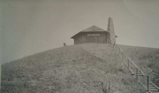
After the state took ownership, these landmarks were destroyed
by arson. The foundation and some scattered walls are all that
remain of the lookout. This is where this cache brings you.
Featured Photo
To encourage posting photos to this cache page, I will update this
spot with my favorite uploaded picture from the last 30 days
(unless no new photos are added in that time).

"Pinnacle Point on a chilly yet beautiful day!" by
oc788@comcast.net
