Gabriach Multi-Cache
Please note Use of geocaching.com services is subject to the terms and conditions
in our disclaimer.
EN: Short multi-cache along paths, approx. 20-30 minutes.
DE: Kurzer Multi-Cache entlang von Wegen, ca. 20-30 Minuten.
ENGLISH DESCRIPTION
Basic information
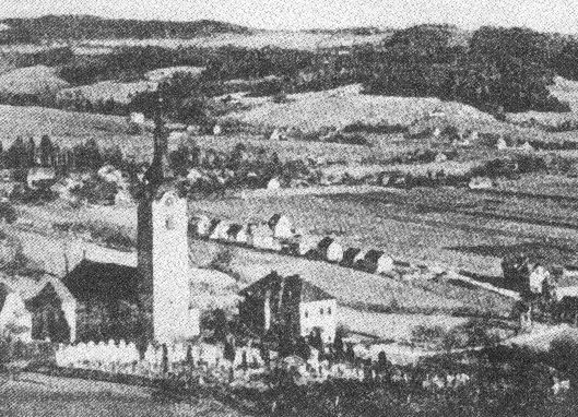
This short multi-cache, which will take approximately 20-30 minutes, will lead you to the church of St. Veit, part of the district Andritz, north of Graz. The church itself is located on a hill, just high enough to offer a view over the city.
It is not recommended to visit this cache at night as some parts of this cache and the final location are located at places where the use of flashlights might either not be appropiate or arouse suspicion.
It's not necessary to enter the coordinates of all the stages into the gps-receiver - most can be found by just following the description. Just in case coordinates are still supplied.
Note: One stage is located on a graveyard. It is just a question to answer and I recommend to act appropiately and put away the gps-r. Relatives of mine found their last home there, so ...
Information found in this description is based on various on- and offline sources. Most should be reliable, but I can't guarantee their validity.
Approach
Car: I'd recommend to leave your car along the street where the parking coordinates - waypoint PARK, N47 06.817 E015 24.835 - are pointing to. There are some places around stage 1 where one could leave a car, but they are all marked as private property.
Bike: Take bike-way R2 north along the left (east) side of the river "Mur". If you approach from south you will pass a big DIY store ("Baumax"). Shortly afterwards - at waypoint BIKE, N47 06.434 E015 24.689 - turn right onto a small unpaved path. You will then drive along the so-called "Kirschenallee" (which basically translates to "cherry tree avenue") and pass some public sports grounds. Follow the path which then turns into a small paved road until you reach a street crossing. There turn right for a few meters, then left. Continue and you'll arrive at stage 1. You can then either continue by bike or leave it there.
Public transport: Take GVB bus #53 ("Hauptbahnhof-Stattegg/Fuss der Leber") and leave at station "St. Veit" (after "St. Gotthard"). This bus line also passes by the station "Andritz" which can be reached by GVB tram lines 4 and 5 and bus-lines 41 and 52. Bus/Tram-timetable available here.
Name
The settlement around the church used to be called "Gabriach", stemming from the Slavic word "gaber" which means hornbeam tree ("Weissbuche"). Today the nearby creek named "Gabriachbach" still refers to that name.
The hill of todays St. Veit used to be called "Am Aigen", which basically translates to "free property" - contrary to the back-then common fiefdom. Today a nearby street still reminds of that name.
By 1850 the municipality of "St. Veit ob Graz" was created. 1938, when todays district Andritz was annexed by Graz, the area became a part of Andritz, todays Graz' 12th district.
History
In the early middle ages the hill of (now) St. Veit used to be the base for an escape castle. Later on fortified defence towers were built, where people found shelter during the Hungarian invasion. The wooden walls were then replaced with stone and a nave was built, first referenced in books by 1226.
In the 17th century todays church, designed by the Italian builder Domenico Sciassia (died in Graz February 19th, 1679) who also extended the Basilica of Mariazell (1644-1683), was built. He also built the chapel at the nearby castle St. Gotthard, but this chapel was teared down in 1808.
Works on the building in St. Veit finished 1662 and 1680 a baroque high altar was created by Hans Adam Weißenkirchner, painter at Eggenberg, donated by prince Seyfried of Eggenberg. In 1713 the churchtower was built (re-built in 1951).
By 1780 children were educated in a room of a tavern next to the church. 1901 todays' school was built.
1906 the first power lines were laid and electric light could be used.
Stage 1: chapel
At stage 1 - N47 06.854 E015 24.798 - you'll find a small chapel, a reminder for the times when Pest plagued the residents.
Nearby there are two direction signs, a green one below a white one.
A = number of graphical symbols on the second sign (the green one) excluding the arrow
B = number of letters of the last word of the inscription of the chapel (6 words)
Note: The inscription was overpainted during the last renovation works. You will find an older picture of the chapel on a sign nearby where you can spot the old inscription.
Now follow the street uphill.
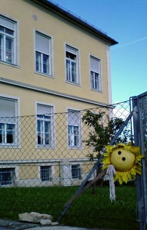
Stage 2: the school
The first building to your right is the school of St. Veit. In Winter the slope below the gym hall is a very popular place for luging.
N47 06.919 E015 24.731
A work of art by small artists, Natalie and others.
C = last digit of the year, 200x
Now continue uphill until you reach a street to your left. |
 |
Stage 3: memorial of war
N 47° 06.934 E 015° 24.704
D = Nearly the last digit of the date: 1860 19x5
If you came by bike leave it there, we'll pick it up later.
Now take the street to your left, and walk along until you reach a parking lot. While walking there have a look at the city to your left.
 |
Stage 4: a warning
N47 06.930 E015 24.624
At the right side of the parking lot near the path to the church you'll find a sign with a red edge.
E = Number of question marks on the sign
(0? E=0; 1? E=1; 2? E=2, 3? E=3, ..)
Now continue to the church, but please put away your gps-r first. It's a graveyard, not your playground.
Stage 5: cross
No coordinates are given for this stage (for obvious reasons). The target is a (really) large wooden cross on the South side of the church building.
F = second digit on the cross
Now continue around the church until you reach some stairs leading to the street below. Right next to the stairs there is a wooden door which leads onto the concrete archway that you might have spotted from stage 3 and to the parsonage. I am not sure if entering the archway is allowed though, so we just walk down the stairs.
If you left your bike at stage 3 go down the few meters and fetch it, then come back up here.
Then continue on the street that's straight ahead until you reach a gravel road that leads downhill to your right. |
Stage 6: famous guy
One of the best-known people in St. Veit was Lois Steiner (1907-1989), who used to be headmaster of the nearby school and is known for collecting Styrian folk songs.
You should now be close to a street carrying his name.
N47 07.035 E015 24.719
Here are two round signs with red edges on the same pole.
G = Twice the first digit of the sign that contains two digits. (The result is a single digit!)
If one would continue walking on the same street one would reach the post office of 8046 St. Veit, which was abandoned in June 2002. It looks like it was frozen in time, there are still advertisements from 2002 on its door..
Now take the gravel road downhill towards the "Gabriachbach".
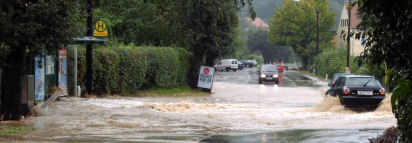
This creek has it's source north of the church of St. Veit and flows into the "Andritzbach" near the B67a (bikeway R2). Parts of the flow of this creek are then used on the area of the cities northern waterworks (right across the street of waypoint BIKE) for artificial groundwater recharging purposes. The creek then flows into the river "Mur".
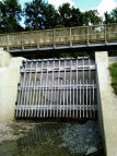
Below you'll see a more or less interesting construction - a retention pond for 26.200 cubic meters of water. It was recently built together with other installations at a cost of 2 billion euro in a response to the flooding that occured on August 21st, 2005, that devastated nearby basements and great parts of the allotment garden south-west of the parking coordinates. A picture timeline of its construction is available here.
Stage 7: Nice place
N47 06.994 E015 25.054
You have arrived at a rather nice place which used to be the final location for this cache for more than 10 years. During this time the area became a playground and the container went missing a few times.
Because of that you now have to answer a rather boring question:
H=What do you see?
2 - a yellow boundary stone
4 - a red warning sign
8 - a green birdhouse
By now you should already have all the necessary values for calculating the location of the final stage, the cache box.
N47 0(D-1).A(H+E)F E015 2C.E(C+G)(B+H) (no multiplications!)
The cache is covered with pieces of bark.
Way back: Follow the gravel road near Stage 7 south towards Stage 1.
HAVE FUN!
DEUTSCHE BESCHREIBUNG
(übersetzt aus der englischen Beschreibung)
Basic information
Dieser kurze Multi-Cache, fuer den etwa mit 20-30 Minuten Zeitaufwand zu rechnen ist, wird dich zur Kirche von St. Veit, Teil des Bezirks Andritz im Norden von Graz, führen. Die Kirche selbst liegt auf einem Hügel, gerade hoch genug um eine Aussicht auf die Stadt zu bieten.
Es ist nicht empfohlen den Cache in der Nacht zu besuchen, da einige Teile des Caches sowie die Endlocation an Stellen versteckt sind, wo die Verwendung von Taschenlampen nicht passend wäre oder Verdacht erregen würde.
Es ist nicht notwendig alle Koordinaten der einzelnen Stages ins GPS einzutippen - die meisten Stationen können auch allein durch die Beschreibung gefunden werden. Für den Fall des Falles sind die Koordinaten dennoch angegeben.
Hinweis: Eine Station befindet sich auf einem Friedhof. Es handelt sich dabei nur um eine zu beantwortende Frage und ich bitte die werten Besucher sich entsprechend zu verhalten - und das GPS wegzupacken. Verwandte von mir haben dort ihre letzte Ruhestätte gefunden, also ...
Die Informationen dieser Beschreibung basieren auf verschiedenen On- und Offline-Quellen. Die meisten sollten zuverlässig sein, allerdings kann ich ihre Korrektheit nicht garantieren.
Approach
Auto: Ich empfehle das Auto entlang der Strasse, zu der die Parkkoordinaten zeigen (waypoint PARK, N47 06.817 E015 24.835), zu parken. Es gibt einige Stellen in der Nähe von Stage 1, wo man ein Auto parken könnte, allerdings sind diese als Privatgrund ausgewiesen.
Rad: Folge dem Murradweg R2 Richtung Noren entlang der linken (Ost) Seite der Mur. Wenn du von Süden kommst fährst du an einem grossen Baumarkt ("Baumax") vorbei. Kurz danach bei Waypoint BIKE, N47 06.434 E015 24.689 biege rechts auf einen kleinen Pfad ab. Du fährst dann entlang der sogenannten "Kirschenallee" und kommst an einer öffentlichen Sportstätte vorbei. Folge dem Pfad, der in eine Strasse mündet, bis du eine Strassenkreuzung erreichst. Dort fahre einige Meter nach Rechts bevor du Links in die dortige Strasse einbiegst. Folge dieser und du erreichst Stage 1. Von dort an kannst du entweder weiter mit dem Rad fahren oder es dort abstellen.
Öffentlicher Verkehr: Nimm GVB Bus #53 ("Hauptbahnhof-Stattegg/Fuss der Leber") und steige bei Station "St. Veit" (nach "St. Gotthard") aus. Diese Buslinie fährt auch bei der Station "Andritz" vorbei, die mit den GVB Strassenbahnlinien 4 und 5 sowie den Bus-Linien 41 und 52 erreicht werden kann. Ein Fahrplan ist hier verfügbar.
Name
Die Siedlung rund um die Kirche wurde früher "Gabriach" genannt, was vom slawischen Wort "gaber" abstammt, das für die Weissbuche steht. Heute trägt der nahe "Gabriachbach" noch immer diesen Namen.
Der Hügel des heutigen St. Veit wurde auch "Am Aigen" genannt, was übersetzt soviel bedeutet wie "freies Eigentum" im Gegensatz zum damals üblichen Lehenswesen. Heute erinnert der Name einer nahegelegenen Strasse an diese Bezeichnung.
Um 1850 wurde die Gemeinde "St. Veit ob Graz" gegründet. 1938, als der heutige Bezirk Andritz an Graz angegliedert wurde, wurde der Bereich ein Teil von Andritz, dem heutigen 12. Grazer Bezirk.
History
Im frühen Mittelalter war der Hügel von nunmehr St. Veit die Basis einer Fluchtburg. Später wurden befestigte Wehrtürme gebaut, wo die Anwohner Schutz während der ungarischen Invasion fanden. Die hölzernen Wände wurden dann durch Steinmauern ersetzt und ein Kirchenschiff wurde gebaut; erstmals 1226 in Büchern erwähnt.
Im 17. Jahrhundert wurde die heutige Kirche gebaut, geplant vom italienischen Baumeister Domenico Sciassia (starb in Graz am 19. Februar 1679), der auch die Basilika von Mariazell erweitert hat (1644-1683). Er baute auch die Kapelle am nahen Schloss St. Gotthard, die 1808 abgetragen wurde.
Die Arbeit am Gebäude in St. Veit waren 1662 beendet. 1680 wurde ein barocker Hochaltar von Hans Adam Weißenkirchner geschaffen, der zu dieser Zeit Maler am Hof der Eggenberg war. Gespendet wurde dieser Altar von Prinz Seyfried von Eggenberg. 1713 wurde der Kirchturm gebaut (Neubau 1951).
Um 1780 wurden Schüler in einem Raum des nahen Gasthauses neben der Kirche unterrichtet. 1901 wurde die heutige Schule gebaut.
1906 wurden die ersten Stromleitungen verlegt und elektrisches Licht konnte genutzt werden.
Stage 1: chapel
Bei Station 1 - N47 06.854 E015 24.798 - findest du eine kleine Kapelle, eine Erinnerung an die Zeit als die Pest die Anwohner heimgesucht hat.
Daneben gibt es zwei Wegweiser, einen Grünen unter einem Weissen.
A = Anzahl der grafischen Symbole (ohne dem Pfeil) am zweiten Wegweiser (grün)
B = Anzahl der Buchstaben des letzten Wortes der Inschrift der Kapelle (6 Wörter)
Hinweis: Bei den letzten Renovierungsarbeiten wurde die Inschrift übermalt. Du findest sie jedoch noch auf einem Foto der Kapelle auf einer Tafel in der Nähe.
Nun folge der Strasse auf den Hügel.
Stage 2: the school
Das erste Gebäude zu deiner Rechten ist die Schule von St. Veit. Im Winter ist der Hang vor dem Turnsaal ein beliebter Platz zum Schlittenfahren.
N47 06.919 E015 24.731
Ein Kunstwerk von kleinen Künstlern, Natalie und die Anderen.
C = letzte Stelle der Jahreszahl, 200x
Gehe nun weiter bergauf bis Links eine Strasse abzweigt. |
|
Stage 3: memorial of war
N 47° 06.934 E 015° 24.704
D = Die vorletzte Stelle der Jahreszahl: 1860 19x5
Wenn du mit dem Rad gekommen bist stelle es hier ab, wir holen es später ab.
Nun nimm die Strasse zu deiner Linken und gehe sie entlang bis du einen Parkplatz erreichst. Während du dorthin gehst schau' dir die Stadt zu deiner Linken an.
|
Stage 4: a warning
N47 06.930 E015 24.624
Auf der rechten Seite des Parkplatzes in der Nähe des Weges zur Kirche findest du ein Schild mit einem roten Rand.
E = Anzahl der Fragezeichen auf dem Schild
(0? E=0; 1? E=1; 2? E=2, 3? E=3, ..)
Gehe nun weiter zur Kirche, aber packe zuvor das GPS ein. Es ist ein Friedhof, nicht dein Spielplatz.
Stage 5: cross
Für diese Station gibt es aus verständlichen Gründen keine Koordinaten. Das Ziel ist ein (wirklich) grosses Holzkreuz auf der Südseite der Kirche.
F = zweite Ziffer auf dem Kreuz
Gehe nun um die Kirche herum bis du eine Stiege erreichst, die zur Strasse hinunterführt. Rechts dieser Stiege befindet sich eine Holztür, die auf den Bogengang, den du vielleicht schon von Stage 3 aus gesehen hast, sowie zum Pfarrhaus führt. Ich weiss nicht ob das Betreten des Bogenganges erlaubt ist, also nehmen wir einfach die Stiege zur Strasse.
Wenn du dein Rad bei Stage 3 stehengelassen hast kannst du es nun holen gehen (und wieder zurück herauf kommen).
Dann folge der Strasse die gerade vor dir liegt bis du rechts einen Schotterweg erreichst der bergab führt. |
Stage 6: famous guy
Einer der bekanntesten Menschen in St. Veit war Lois Steiner (1907-1989), der Direktor der nahen Schule war und bekannt für seine Sammlung Steirischer Volkslieder war.
Du solltest dich nun in der Nähe einer Strasse befinden, die seinen Namen trägt.
N47 07.035 E015 24.719
Hier gibt es zwei runde Schilder mit rotem Rand auf der selben Stange.
G = Die erste Ziffer des Schildes mit zwei Ziffern mal zwei. (Das Resultat ist eine einzelne Ziffer!)
Würde man der Strasse weiter folgen, so käme man beim Postamt 8046 St. Veit vorbei, das im Juni 2002 aufgelassen wurde. Es hängt noch immer Werbung aus dem Jahr 2002 auf der Tür..
Nun nimm die Schotterstrasse bergab in Richtung "Gabriachbach".
Dieser Bach hat seine Quelle nördlich der Kirche von St. Veit und fliesst in den "Andritzbach" in der Nähe der B67a (Radweg R2). Ein Teil dieses Wassers wird dann im nahen Wasserwerk (gleich gegenüber des Wegpunkts BIKE) für die Grundwasseranreicherung benüzt. Der Bach fliesst dann in die Mur.
Unter dir siehst du eine mehr oder weniger interessante Konstruktion - ein Rückhaltebecken für 26.200 Kubikmeter Wasser. Es wurde unlängst zusammen mit anderen Konstruktionen bei Kosten von 2 Millionen Euro nach den Überflutungen des Hochwassers vom 21. August 2005 gebaut. Damals wurden nahegelegene Keller und grosse Teile des Heimgartens süd-westlich der Parkkoordinaten überflutet. Eine Bilder-Zeitleiste der Konstruktion ist hier verfügbar.
Stage 7: Nice place
N47 06.994 E015 25.054
Du solltest nun an einem schönen Plätzchen angekommen sein dass für über 10 Jahre die Final-Location dieses Caches war. Während dieser Zeit wurde aus dem Gebiet mehr oder weniger ein Spielplatz; dadurch ist auch die Dose einige Male verschwunden. Aus diesem Grund gibt es hier nun nur eine langweilige Frage:
H=Was siehst du?
2 - einen gelben Grenzstein
4 - eine rote Warntafel
8 - ein grünes Vogelhäuschen
Du solltest mittlerweile alle notwendigen Werte haben um den Platz der Cachebox errechnen zu können.
N47 0(D-1).A(H+E)F E015 2C.E(C+G)(B+H) (keine Multiplikationen!)
Die Cachebox ist mit Rinde bedeckt.
Rückweg: Folge dem Schotterweg nahe Stage 7 nach Süden in Richtung von Stage 1.
VIEL SPASS!
Additional Hints
(Decrypt)
[EN:] Gerr fghzc ng n qvfgnapr bs 2z gb n ovepu gerr, 3z gb n znexrq obhaqnel fgbar.
[DE:] Onhzfghzcs 2z arora Ovexr, 3z arora znexvregrz Teramfgrva.
Treasures
You'll collect a digital Treasure from one of these collections when you find and log this geocache:

Loading Treasures