
You can find Boka Wandomi National Bridge in the Shete Boka National Park, Curaçao's newest national park.
U vindt Boka Wandomi National Bridge in het Nationaal Park Shete Boka, het nieuwste nationale park van Curaçao.
This part of Curaçao, with its crashing waves, is accentuated by several beautiful inlets and caves that are half immersed in water. According to the CARMABI Foundation the most important natural treasures in this area are the nesting beaches of sea turtles. The Foundation strives to protect and improve these nesting beaches.
Dit deel van Curaçao, met zijn beukende golven, wordt geaccentueerd door een aantal mooie inhammen en grotten die voor de helft worden ondergedompeld in water. Volgens de CARMABI Stichting zijn de belangrijkste natuurlijke schatten in dit gebied de neststranden van de zeeschildpadden. De Stichting streeft naar de bescherming en verbetering van deze neststranden.
From Curaçao's capital Willemstad follow the road to Westpunt. Take the exit at the "Shete Boka National Park" sign (N 12°21.845 - W 069°07.010). Follow the road to the entrance of the park. Pay a small entrance fee and park your car near N 12°22.050 - W 069°06.980. Please respect the rules of the park! The only facilities in the park are near the park entrance, therefore: make sure you have enough to drink during your stay in the park!
Volg vanaf Willemstad de weg naar Westpunt. Neem de afslag ter hoogte van het "Shete Boka National Park"-teken (N 12 ° 21.845 - W 069 ° 07.010). Volg de weg naar de ingang van het park. Betaal een de (relatief lage) toegangsprijs en parkeer uw auto in de buurt van N 12 ° 22.050 - W 069 ° 06.980. Respecteer svp de regels van het park! De enige voorzieningen in het park zijn in de buurt van de ingang van het park zorg dus dat u voldoende drinken bij u heeft tijdens uw verblijf in het park!
Start at stunning Boka Tabla, where huge waves thunder into an underground cavern. Steps cut into the rocks lead you directly into the mouth of the cavern; you can sit on the very edge and watch the surf roll in. After you peek inside the cavern mark the coordinates of the platform next to the entrance!. You can walk along the limestone bluffs above for a spectacular view of Curaçao's rugged north coast.
Begin bij de prachtige Boka Tabla alwaar enorme golven inbeuken op de onderaardse grot. Uit de rotsen gehakte traptreden leiden u direct naar de toegang van de grot. U kunt zitten op de rand en kijken naar de rollende golven binnenin. Nadat het kijkje in de grot noteert u de coördinaten van het platform naast de ingang! U kunt vervolgens via/langs de kalkstenen kliffen naar boven wandelen voor een spectaculair uitzicht over de ruige noordkust van Curaçao.
Then you must go to the observation platform of Boka Wandomi Natural Bridge (N 12°22.346 - W 069°07.376). Follow the trail in northwestern direction (about 1 km or 650 ft) or return to you car and drive to the parking area near the bridge.
Vervolgens ga je naar het observatieplatform van Boka Wandomi Natural Bridge (N 12 ° 22.346 - W 069 ° 07.376). Volg het pad in noordwestelijke richting (ongeveer 1 km of 650 ft) of terug naar je auto en rij naar de parkeerplaats nabij de brug.
The huge and beautiful natural bridge was carved out by the water of the Caribbean sea. Now Boka Wandomi National Bridge is one of the most impressive natural bridges in the area.
De enorme en prachtige natuurlijke brug werd gevormd door het water van de Caribische zee. Boka Wandomi National Bridge is dan ook een van de meest indrukwekkende natuurlijke bruggen in het Caribische gebied.

To log this first earthcache of Curaçao as a 'found' you must complete two assignments:
a) find out the exact distance in meters or feet between the observation platform of Boka Wandomi National Bridge and the observation platform next to the entrance of the cavern of Boka Tabla. Make sure you are at the right observation platform, some geocachers went to the wrong one! Mail me the answer, but don't mention the answer in your log.
b) post a picture of you and your GPSr visible. You must stand at the viewpoint next to the natural bridge. Log your visit only when you can upload your picture at the same time!
Om deze eerste earthcache te loggen als een 'found' dient u twee opdrachten uit te voeren:
a) Het vaststellen van de exacte afstand in meters of voet tussen het observatieplatform van Boka Wandomi National Bridge en het observatieplatform naast de ingang van de grot van Boka Tabla. Zorg ervoor dat u op het juiste observatie platform bezoekt, sommige geocachers gingen naar de verkeerde! Mailmij svp het antwoord. Plaats dit niet in je log!!
b) het plaatsen van een foto van uzelf met uw GPS zichtbaar. U dient te staan bij het uitzichtpunt naast de natuurlijke brug.
Log uw bezoek alleen wanneer u uw foto ook direct upload!
Natural Bridges on Mars?
A possible natural bridge on Mars is to be seen at a picture taken by the High Resolution Imaging Science Experiment, abbreviated HiRISE. HiRISE is a camera onboard the Mars Reconnaissance Orbiter (MRO) which has been orbiting and studying Mars since 2006. The spacecraft began its high-resolution imaging of Mars on November 7, 2006.
The possible natural bridge is to be found at Mars latitude 24.471°, longitude 188.130°. The observation made on November 15, 2006 shows a thin channel between knobs in the Northern hemisphere. These knobs are part of a local group of knobs called the Tartarus Colles.
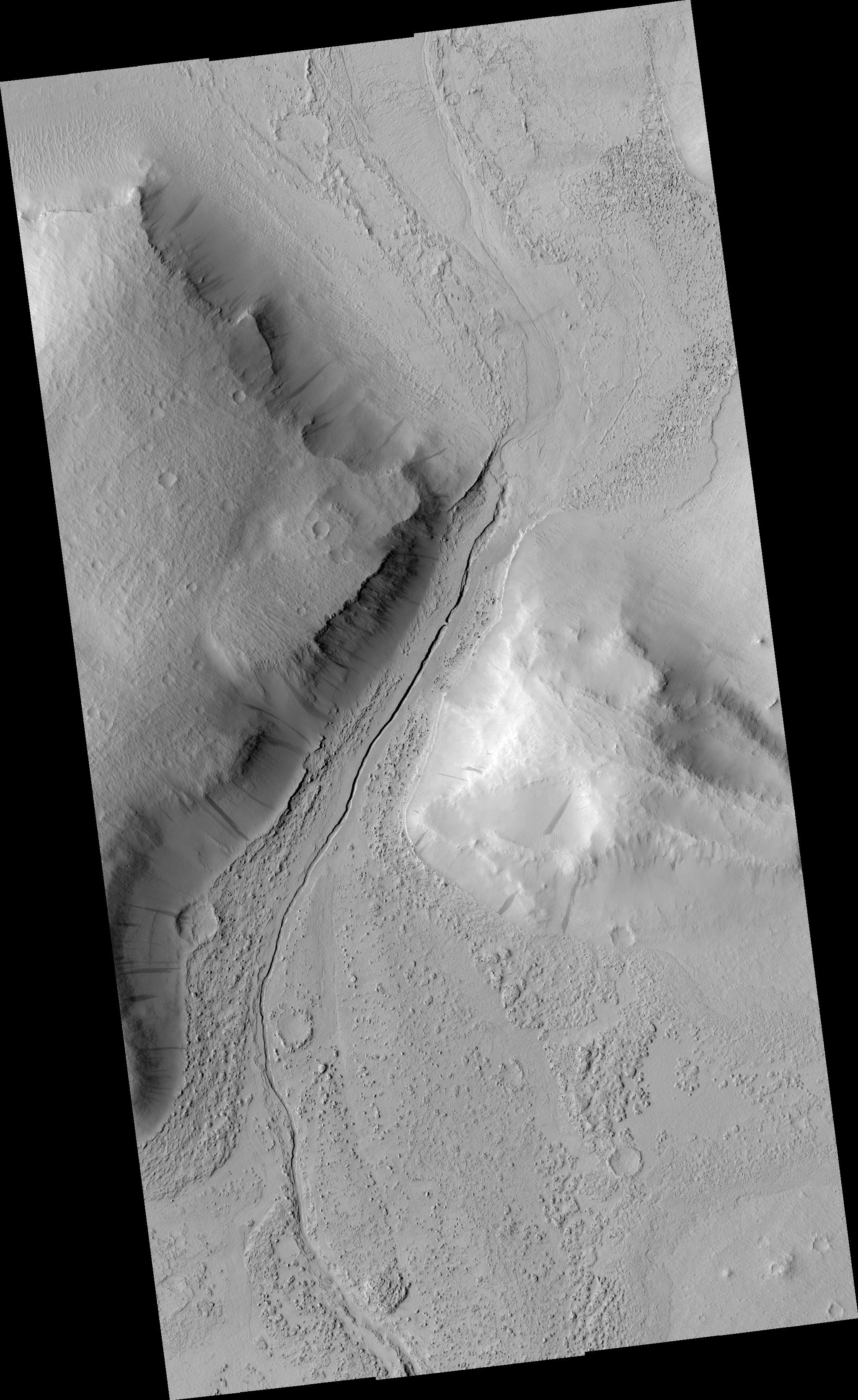
Above the original picture registered under number PSP_001420_2045.
More detailed you can see the possible natural bridge in the below picture.
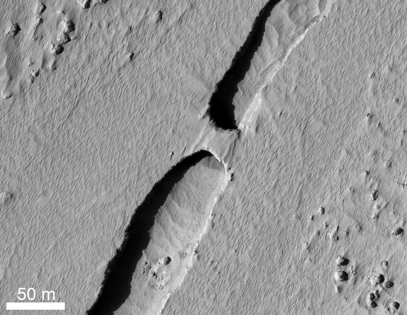
The thing about "possible".
It is a 'possible' natural bridge because maybe it is just a wall.
Also, the way the bridges were formed is not 100% clear, yet. Options are it was made by the influence of water and erosion or it is a result of lava. On Earth, all the natural arches currently documented are very young geologically. None are likely to be older than about 50,000 years and most are much younger.
However, this is a consequence of the processes and rates of erosion that occur on Earth. These processes and rates may not pertain to Mars. When asking how old this arch is, or how it formed, we have to account for what the characteristics of Martian erosion might be.
One obvious indication that erosion rates are slower on Mars than on Earth is the much greater number of visible impact craters on the Martian surface. This is not the result of a higher frequency of impacts on Mars. It is because the impact craters on Earth erode into obscurity very rapidly. They last longer on Mars. Similarly, slower erosion rates could mean that natural arches on Mars have a longer lifespan on average than their terrestrial cousins.
To obtain certainty about the actual situation, an on-site investigation will have to be carried out. We will probably have to wait a while for this.
For now, the widely held belief is that the bridge is a lava natural arch.
Special thanks to NASA/JPL/University of Arizona for the images.
Counter active since 06-12-2020
