
 There is a pull off large enough for a couple of vehicles
on the west side of the road. From there you can see Hayden
Valley cut down into the lake sediments and Trout Creek
meandering through it. The formation of these
meanders began with the last
glaciation.
There is a pull off large enough for a couple of vehicles
on the west side of the road. From there you can see Hayden
Valley cut down into the lake sediments and Trout Creek
meandering through it. The formation of these
meanders began with the last
glaciation.
During that glaciation that occurred between 70 and 13 thousand
years ago called the Pinedale glaciation, a dam formed across the
Yellowstone River near the Upper Falls of the Grand Canyon of
Yellowstone. A series of layers of fine sand, silt and clay formed
in the bottom of the lake. Evidence of these sediments can be seen
in the cliffs on either side of the valley, but are most easily
identified on the south side. One section of cliff shows an ancient
stream channel that was filled by later sediments.
 These lake sediments created a very flat
valley. In areas of low slope, the path of the river begins to
wander back and forth creating meanders, curves.
These lake sediments created a very flat
valley. In areas of low slope, the path of the river begins to
wander back and forth creating meanders, curves.
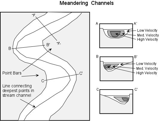
Along each curve, the flow of the river is constantly eroding
the outside bank of the meander, while at the same time depositing
material on the inside. This is because the area of fastest flow in
the river is forced to the outside bank on the curves and the
slowest flow is on the inside. Faster water carries more sediment
causing the erosion. The slower water is unable to carry as much
sediment, so some sediment drops out of the water.
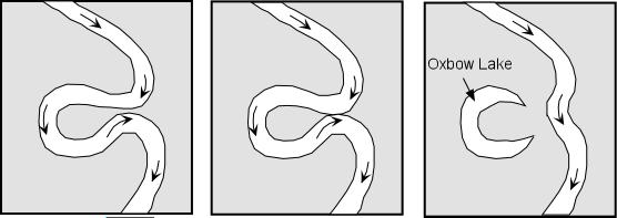 Over time, this erosion on the outer bank of
each turn in the river exaggerates each turn until the
meanders turn back on themselves and meet. The river then
changes course slightly and takes the shorter route through
the connected meander, leaving the other branch of the meander
as oxbow lake.
Over time, this erosion on the outer bank of
each turn in the river exaggerates each turn until the
meanders turn back on themselves and meet. The river then
changes course slightly and takes the shorter route through
the connected meander, leaving the other branch of the meander
as oxbow lake.
Another way for a meander to be abandoned is through a flood.
The high flow during a flood bypass the long winding pathways for a
more direct route before the meanders have a chance to connect.
An animation of river meander formation can be found at
http://www.cleo.net.uk/resources/displayframe.php?src=309/consultants_resources%2F_files%2Fmeander4.swf
Logging requirements:
Send me a note with :
- The text "GC14YVA Meanders at Trout Creek " on the first
line
- The number of people in your group.
- Identify how many oxbow lakes are within sight of the overlook
(be sure to look for water in it).
- go to the secondary coordinates (an overlook of the Yellowstone
river a little north of this overlook) and determine how many
meanders there are and how close they are to creating an oxbow
lake.
The above information was compiled from the
following sources:
- All images from Prof. Stephen A. Nelson, Tulane
University. Click images for a larger version
- Fritz, William J., Roadside Geology of the
Yellowstone Country, Mountain Press Publishing Company, May
1989.
Placement approved by the
Yellowstone National Park