English:
Stolpener
Basalt:
Stolpen
basalt was classified as one of the significant geotypes of Germany
by the academy of geosciences, Hanover in 2006.
In
connection with the basalt of Stolpen, the name “basalt” was used
first. This is why Stolpen is known as a so called “type
location”.
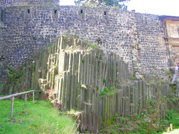
Formation:
In
the area of the hill in the castle, a crack appeard which was about
15 km deep. This crack reached the upper layer of earths mantle and
it was formed by tectonic movements in the middle and south of
Europe. Hot Magma could emerge through the so called Lausitzer
Massiv. The Magma got cold on the outside of the earth and formed a
cover above the hole. Due to this cover, more Magma from the inside
of the earth core was not able to reach the surface and formed
these basalt columns. The cover disappeared by the erosion of the
centuries, but the columns are left and can now be
admired.
And
here are my educational questions: To log this Earthcache, take a
photo of yourself in front of “basalt column” and send me the
answers to 2 of the following questions in an email (not in the
log) to chronosdd@gmx.de with Betreff Stopener
Basalt:
-
When did the
basalt columns form?
-
Who first used
the name “basalt” in 1546?
-
Describe the
form of separation of the basalt columns in
Stolpen!
Deutsch:
Stolpener
Basalt:
Die Stadt
und die Burg Stolpen verdanken ihren Namen dem Basalt. „
Stolp“ ist ein
altslawisches Wort und bedeutet Säule. Der Basalt von
Stolpen wurde durch die Akademie der Geowissenschaften zu Hannover
e.V., 2006 zum "Nationales Geotop" erklärt. In Zusammenhang mit dem
Stolpener Basalt wurde zum ersten Mal
der Begriff „Basalt“ verwendet, darum wird Stolpen auch als
Typuslokalität bezeichnet
Entstehung:
Im Bereich
des Burgberges entstand ein mindestens 15 km tiefer Riss bis zum
oberen Mantel der Erde, hervorgerufen durch tektonische Bewegungen
in Mittel- und Südeuropa. Nun konnte Magma durch das
Lausitzer Massiv dringen. Die an der
Oberfläche erkaltende Lava, bildete einen
Schlackendeckel.
Wegen dieses
Schlackendeckels konnte das aus dem Erdinneren Nachdringende Magma
nicht mehr an die Oberfläche durchdrücken, es entstanden die
Basaltsäulen in einer so genannten Quellkuppe. Der Schlackendeckel
wurde durch viele Jahrtausende abgetragen und so blieben die Säulen
stehen.
Nun zur
Bildungs-Aufgabe des
Earthcaches:
Um diesen Earthcache loggen zu dürfen,
mache bitte ein Foto von Dir vor Ort (Basaltsäulen) und beantworte
mir mindestens 2 der folgenden Fragen in einer Email (nicht im Log)
an chronosdd@gmx.de mit dem Betreff
„Stolpener Basalt“:
1. Wann entstanden die Basaltsäulen (Zeitalter oder Jahre)?
2. Wer verwendete in Stolpen den Namen Basalt als Erster im Jahr
1546?
3. Beschreibe die Form der Basaltsäulen!