Pinka EarthCache
-
Difficulty:
-

-
Terrain:
-

Size:  (not chosen)
Related Web Page
Please note Use of geocaching.com services is subject to the terms and conditions
in our disclaimer.
PINKA
![[CNW:Counter]](https://imgproxy.geocaching.com/167f3c86172ad42cf1fff62bf89da5eedcf5b29d?url=http%3A%2F%2Fcounter.cnw.cz%2Fneuropol.cgi%3FEARTH_Pinka%265%26FFFFFF%26000000%26on)

Czech

Pinka – Poklesová propadlina
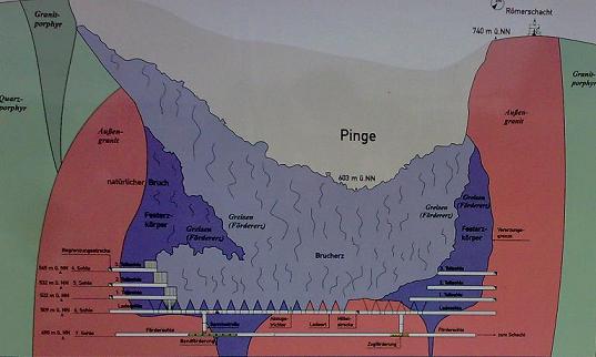
Pinka je památník historie hornictví v Altenbergu. Vznikla
velkoplošným propadem vybouraného prostoru podzemí dolu. Od té doby
se zde teží spodem pinky zpusobem odtežování rubaniny.
(Mlýnkování). Od roku 1976 dochází ješte k dodatecné težbe žíly
metodou mezipatrového závalu. Trhacími prácemi predem pripravený
zával zpusobil vznik odtežovacího trychtýre na dve pinky v hloubce
230 m, kde se hornina odtežovala. Dobýváním tímto zpusobem dochází
k prirozenému prolamování vrstev a k jevu vystupujícím až na
povrch. Propadlina se zvetšovala rok od roku težby.
Težba cínu od roku 1440 do roku 1991. Vyteženo 32 mil. tun Produkce
cistého cínu 106 000 tun. Zustatek surové rubaniny 27 mil. tun
Teoretický obsah cínu 72 000 tun.
Pinku si lze prohlédnout pouze v doprovodu pruvodce: kveten – ríjen
vždy ve stredu v 13:30, místo setkání pred nádražím Další
informace: Hornické muzeum Altenberg Tel: (0049) 35056 31703
Kdy zacala težba (rok)?
Jaký je prumer?
Jaká je hloubka?
Jaká je plocha?
Dále k logu priložte fotografii sebe na míste souradnic N50°46.030
E13°46.018 dle priloženého spoileru a foto lomu se souradnicemi
tohoto místa. Odpovedi zašlete na email: geo.marzcz@seznam.cz s
predmetem „Earth-Altenberg“.
Deutsch

Die Pinge
Durch unkontrolliertes Aushöhlen des Altenberger
Zinnerz-Zwitterstockes infolge Feuersetzens traten bereits 1545
erste Brüche auf. Danach wurde das Erz sowohl aus dem Festgestein
als auch aus der Bruchmasse gewonnen. Durch Fortführung des
ungehemmten Feuersetzens im Festgestein entstanden erneut große
Weitungsbaue, die dem Druck des Deckgebirges nicht standhielten.
1578, 1583, 1587 und 1619 kam es zu weiteren Brüchen, wobei nicht
geklärt ist, ob diese absichtlich herbeigeführt wurden. In den
folgenden Jahrhunderten wurde der Bergbau durch Förderung der
Bruchmassen „von unten“ bis 1991 fortgeführt. Heute ist die Große
Pinge nicht nur eine der Attraktionen Altenbergs, sie wurde zudem
im Mai 2006 von der Akademie der Geowissenschaften zu Hannover als
eines der 77 bedeutendsten nationalen Geotope Deutschlands
prädikatisiert.
Zinnerzabbau um 1440 bis 1991 Abgebaute Roherzmenge 32 Mill. Tonnen
Daraus erzeugtes Reinzinn 106 000 Tonnen Verbliebener Zinnerzvorrat
27 Mill. Tonnen Theoretischer Zinngehalt 72 000 Tonnen Geführte
Pingewanderungen ist möglich: Mai bis Oktober jeden Mittwoch
ab13,30Uhr Treffpunkt Bahnhofsvorplatz Weitere Information:
Bergbaumuseum Altenberg Tel: (0049) 35056 31703
Nun zur Bildungs-Aufgabe des Earthcaches: Um diesen Earthcache
loggen zu dürfen, mache bitte ein Foto beim Koordinaten N50°46.030
E13°46.018 nach dem Spoilerfoto und beantworte mir folgende Fragen
in einer Email (nicht im Log) an geo.marzcz@seznam.cz mit dem
Betreff Earth-Altenberg.
Wann begann der Bergbau (Jahr)?
Wie groß ist der Durchmesser?
Wie groß ist die Tiefe?
Wie groß ist die Fläche?
English

Pinka – downswing depression
Pinka – downswing depression Pinka is the memorial of mining
history in Altenberg. It has been formated by large ground
depression of underground space in the time when the spoil mining
began. Since 1976 the mining was extended for additional ore-vein.
Mining funnel has been created by explosion of prepared cave-in in
the depth of 230 m where the ore was mined out. This way of mining
caused natural quarrying of ground layers up to the surface. The
whole depression is enlarging since the mining time.
There has been mining of tin here since 1440 till 1991. 32 tons
mined out. Pure tin gain 106 000 tons raw spoil balance 27 mil.
tons Theoretical tin volume 72 000 tons
You can visit Pinka only with the guide only, each Wednesday 13:30
within May – October, meeting point in front of railway station
Further information available at Mining Museum in Altenberg Tel:
(0049) 35056 31703
Then please attach your photo in the place of coordinates
N50°46.030 E13°46.018 in accordance with attached spoiler and the
photo of quarry with its coordinates. Email your answers to:
geo.marzcz@seznam.cz , subject: „Earth-Altenberg“.
When did the mining begin? (year)
What is hole's diameter?
What is its total depth?
What is the total area space?

http://www.altenberg.de
 >
>


Additional Hints
(Decrypt)
Jnyx nebhaq gur dhneel.