CORRECTION SURVEY LINES III
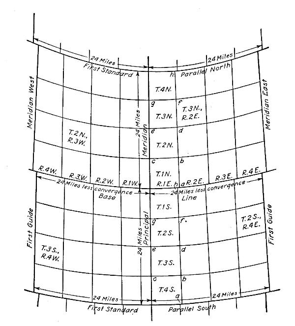
In the late 1800’s government surveyors were commissioned to lay out the public lands (Oklahoma Territory) into a grid in preparation for sale or grant to the public. These grids were to be 6 miles square and were known as townships. They would be later divided into 36 smaller units, which are known as sections (640 acres each). In most areas the sections were divided into even smaller squares or Quarter Sections (160 acres). Iron posts were set at the corners of the townships and stones were placed at all of the section and quarter corners. Some of these stones can still be found today if the area is wooded or otherwise has not been disturbed.
While surveying these townships, the early surveyors were instructed to survey Due North (magnetic). As they went north they would need to correct for the curvature of the earth or eventually all of the lines would converge to one common point (the North Pole). It was determined that these corrections would take place every four townships (4 townships x 6 miles each) or 24 miles. These lines are known as Standard Parallels or correction lines. The county roads as we know them today were built primarily along these section lines. If you drive north or south along one of these county roads every 24 miles you might come across a small offset or “jog” in the road. This is where the original surveyors corrected their surveys.
Now you will know why that offset is there, curvature of the Earth!
THE CACHE
This is the third in our Correction Survey Lines series. The original is located West of Oklahoma City Correction Survey Lines I (GC122YE) but is also located along a correction line. This cache was a camo ammo can with several goodies such as scales, pens, highlighters, stickers, neck lanyards, Land Surveying brochures and coloring books. FTF got a calculator. The cache was on private property with permission. The ownership of land has changed, so the container is now a bison tube. Please keep your vehicle on pavement and watch for traffic in this rural county intersection. Keep your eyes open and be safe.
THE OSLS GEOCACHING PROJECT
Through the Geocaching Project, The Oklahoma Society of Land Surveyors (OSLS) has established several geocaches across the state of Oklahoma. Each geocache under this project promotes three topics. The first is, of course, the geocache itself, thereby promoting the sport of geocaching, the Geocaching.com website and environmental responsibility. The second topic is the site where the geocache is placed; typically sites that relate in some way to land surveying and tell the world about it. The third topic is the promotion of surveying as a viable career choice, which is the main purpose of the OSLS Geocaching Project. A good geocache should promote all three topics. This project is an attempt to introduce geocachers to surveying and surveyors to geocaching.
Check out SurveyOklahoma.com for more information on a career in surveying.