The SQ in the cache name above signifies Spirit Quest, a project
to distinguish those caches that are set in cemeteries or memorial
gardens. This is a good distinction to put on this type of cache
and would like to see it used here in Michigan. Please be
respectful of the area, and observe their rules and posted hours,
Only visit cemeteries dawn to dusk through out the state unless
other hours are posted, so that we do not end up like other states
that do not allow any caches placed in any cemeteries!
This is a letter box hybrid cache. The final container has a
rubber stamp and ink pad, please leave these in the cache. The
container is a camouflaged sandwich sized lock-n-lock.
This cache is designed for those who like history and appreciate
Detroit history. This cache is dear to me as I am one of the 4th
generations of family members born within a half mile of Conner
Creek. The cemetery also is the resting place of many of my
ancestors, most important, both sets of my Grandparents!
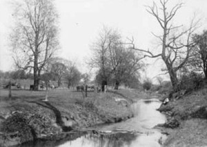
Conner Creek 1907
The posted co-ords will take you to the only part of Conner
Creek that in not encased in piping. At these co-ords there is a
container that has the final co-ords in it. This being a letterbox
I would suggest not using these co-ords as you will have to follow
the route either way. This cache is also set up as a driving
historical tour; this is a great cache for those bad weather days
as the only time you will need to get out of your vehicle is for
the final. So sit back and enjoy!
Because it would be very inconvenient to travel the full length of
where creek ran so I will start with explaining the area. The
farthest back I can find on the creek is dated to 1600's. At that
time the area that is now Warren, Michigan between Van Dyke and
Hoover was mostly wetlands. There were many springs that fed and
gave birth to this creek. These springs were all along the area
between what today is 8 and 9 mile roads. In the 1600 and 1700's
the shores of the creek was occupied by both the Algonquin and the
Iroquois Indians. The creek supported a lot of wildlife, nuts and
berries for them to live by. The creek also was used to travel for
trade with the white man.
The white man started also to settle in the along the creek in the
1700's. At that time the creek was named Trombey’s Creek and
continued to be until around 1818 when it became Conner Creek. The
City adopted the name permanently to Conner Creek in 1827. During
the 1800’s the hard woods were being cut and cleared in this
area to make room for farmland. In the early 1850’s is when
my ancestors settled here on the banks of the creek.
The late 1800’s and into the 1900’s, industries move in
along the creek. Starting with mills and then the car companies.
They used the creek for transporting goods and waterwheels to run
industry. With so much population growth the creek became a danger
to children that played along the shore. Also with the build up of
Detroit’s eastside roads and the airport the creek was piped
up and covered over. So it is still there running below this
cache.
Now that you have a little back ground it is time for the clues.
You are now sitting on a hump in the road that is just above the
creek. It is now time to head north following the route of the
creek. As you travel, your left side is industries that have been
in this area for 80 years and longer. As you head north you will
see the much newer but the same Chrysler’s plant that was
originally built here because of the creeks location. Continue on
until you come to commercial business (including Micky D's). At
this intersection you will be passing the location (N.W. Corner)
where from the 1920’s through 1933 the Detroit Stars played
ball. The Detroit Stars were Detroit’s Negro
National League baseball team. Keep you eyes on the road as you
imagine the past. Continuing north you will see what is left of
other industries that have since pasted, and the small businesses
of today. You are on the right path when you are passing a collage
and then a freeway. To your left after you have crossed over the
freeway and the next intersection you are now looking at another
piece of history. This is the Conner Playfield; it is the only part
of the creek side that has never had a development on it. Conner
Creek runs directly through this park but unfortunately was encased
as the rest of the creek was being done.
Interesting enough this park has now been developed as part of the
Conner Creek Greenway
bike and walking path. What makes it interesting is the fact that
the plans for this greenway were first drawn up by Edward Bennett
in 1915. Some things take time to happen in this city! This park is
the only part of those original plans that was completed and has
never changed from being a city park.
It is time to get back to caching here. Continue north and you will
be passing the wide open land in which the creek run just west of
the runway, you are still on track. You do not have to watch very
close to see the marble orchards running on either side of you.
After passing the orchards you will need to turn west at the next
intersection. Crossing over the creek again, the railroad tracks
that were completed in 1906, and onto the next big intersection.
Heading at a southward direction this wide black path will take you
back to the orchard on your left. Continue until you find a way in
(the only way anymore) which closes at 5:00pm. Enter the orchard
and stay to the right as you follow the outside road around. Be
careful not to go down under the bridge, you will know where it is
by the Calcatera’s black marker. That is where you will have
to stay to the left to keep from going under the bridge. Continue
zigging and zagging along the outside edge as best possible. This
will take you quite a ways to the north where the road turns you to
the left. Now is where you need to move very slow so that you do
not miss the track of the creek. Watch to your left and you will
see the parting of the stones wide enough to tell right where the
creek is encased. Stop here; now look to the north where you will
find 5 of one family, the Deciduous, and 1, the Conifer, all to
itself. Just beyond the 5 to the north you will see the one that
does not seem right here. There with the help of magnets a
letterbox can be found!
Thank you to Sylvansearch for the Spirit of Detroit rubber stamp
that is being used for this letterbox. They put it in their
Clara Smiles cache that we were able to get on our FTF.