Do not try to reach this cache from the Highway edge. #1- THAT
end of the tunnel is covered with thick bars (to stop debris) and
you couldn't get in, and #2- You'd spoil the whole adventure of
this cache.
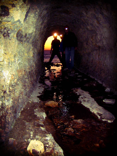
This tunnel differs from others along the coast in that it
empties onto the beach from a height of about 15 feet. You will be
scrambling up a rock promontory to reach the opening. This cache
will only be easily reachable at low tide. High tide or big waves
may make it unsafe to approach the tunnel mouth. Use good judgment.
You can check the tide HERE.
***Also, VERY IMPORTANT- There are two tunnels on the beach.
The first is located immediately at the base of the cliff access
trail. DO NOT ENTER THIS TUNNEL! This tunnel is gated, surrounded
in cement, covered with spray paint graffiti, and leads directly
into the nearby cement plant. The employees at the plant will NOT
be happy with you! Another sign you are in the wrong tunnel will be
a loud, fluctuating humming sound. It'll be very annoying and hurt
your ears. The tunnel YOU are looking for is an unassuming,
unmarked, hole in the cliff side further down the beach. Clear
enough?***
Ok, let's begin- From the cliff access trail (see additional
waypoints) look at the beach below. If the base of the first jetty
tower is out of the water- Then the tide is probably low enough.
Proceed carefully down the sloping cliff. Intimidated by the climb
down? You could rope up (safer, but not required)- Near the top of
the trail is a big metal pole that would work great as an anchor.
Make sure you're familiar with the use of climbing equipment if you
decide to go that route.
It will be up to you to find the 2nd tunnel mouth. Shouldn't be
to difficult- Check the gallery for a visual clue. If the tide is
low enough it should be an easy climb. Watch for slippery rocks!
Enjoy!
GPS signal will obviously be lost for a while under all the
rock, and it won't be that good at the end of the tunnel either.
Coordinates for the cache were averaged over 100 times to a
resolution of 12 feet.
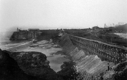
A bit of history for you, since it's come up in the logs. First,
you'll notice, if you look closely, that the Cement Towers on the
beach and in the water line up perfectly with the entrance of the
first tunnel. This tunnel and towers are remnants of an old jetty
pier that the cement plant used to off-load it's product onto
waiting ships out at sea. Built in the 1930's, and used until the
mid 1950's, when the outer section collapsed in a storm.
The second tunnel (that you'll be entering) was carved through the
rock in the early 1900's, when the railroad tracks were built. The
railroad (and later Hwy 1) are the reason we have so many 'pocket'
beaches along this stretch of coast. When the builders came to a
creek valley, they first built a wooden trestle across, then filled
the trestle in with dirt. This had the effect of cutting the beach
off from the land. But what to do with the flowing creek? For each
creek they carved a tunnel through the rock, and out to the coast.
So there you go...
 |
 |
|
...oh, the title? It'll make sense
later...
12/12/07- Congratulations private bones and
Johnnycache FTF! |