De formule voor waypoint 6 is op 4 september 2020 gewijzigd.
De manier om de waarden van A en B te verkrijgen is op 15 mei 2023 gewijzigd.
De informatie bij WP12 is gewijzigd op 19 december 2023.
De informatie bij WP4 en WP5 is gewijzigd 1 augustus 2024.
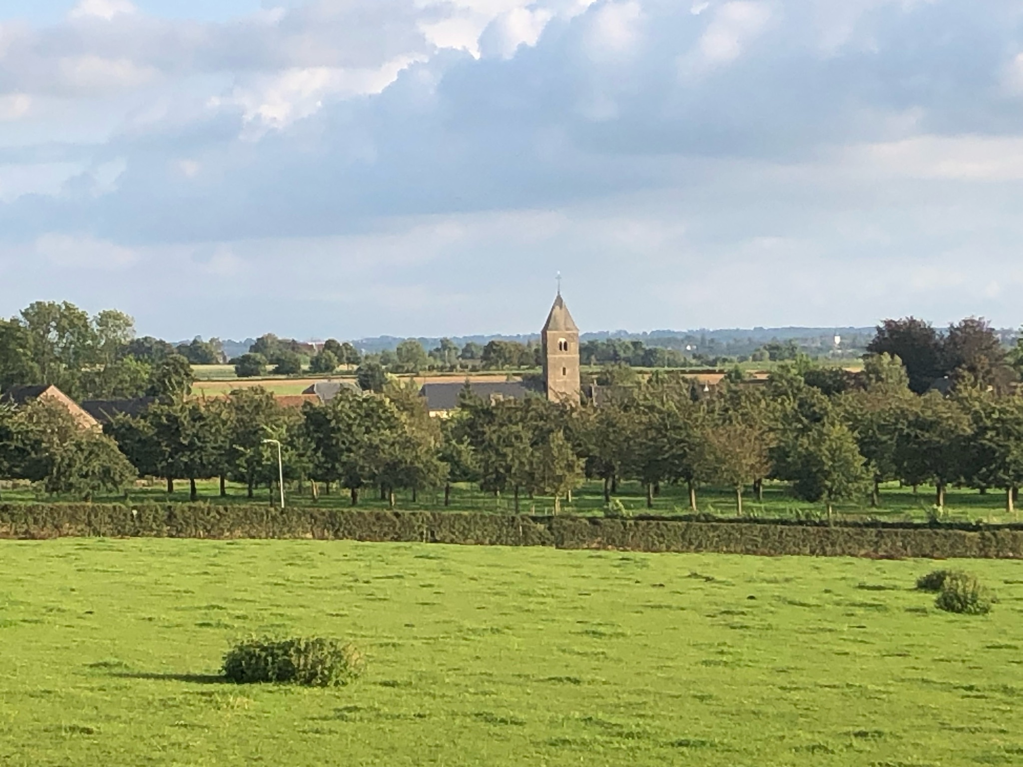
Mesch (Misj), het pittoreske kerkdorp, is het meest zuidelijk gelegen dorp van de gemeente Eijsden-Margraten en grenst aan de Belgische Voerstreek. Mesch, met zijn oude monumentale boerderijen en holle wegen, omringd door hoogstamboomgaarden, meidoornhagen en heuvels is zeer in trek bij wandelaars en fietsers die komen genieten van de rust, de natuur, de eenvoud, de gezelligheid en gastvrijheid! Tussen de fruitbomen en de grazende koeien in de weilanden door, vanaf de hellingen op de Sjtejneberg met zijn wijngaard of de Mescher Hei, ja zelfs vanuit de Belgische Voerstreek, altijd duikt de toren van de fraaie Sint Pancratiuskerk van Mesch als eerste op. Deze kerk, een van Nederlands' oudste stenen gebouwen en de oudste kerk van Limburg, is een bezoekje meer dan waard! Als de kerkklok het Angelus luidt, “hoor” je de rust en kalmte van het dorp.
Het dorpje Mesch ligt verscholen in het sleepdal van het beekje de Voer. Mesch telt met twee plukken huizen langs de Voer en rondom de kerk, zo’n 400 inwoners en is onder andere gelegen aan de lange afstandswandelingen het Pelgrimspad (naar Santiago de Compostella) en het Krijtpad (90 km rondwandeling van Maastricht naar Vaals) en de lange afstandsfietsroute het Fietserpad (500 km naar Groningen).
Print de foto van het kruis uit. Die heb je onderweg nodig.
*** Als je het kruis van de foto onderweg tegenkomt, zoek daar dan een plaatje waar GR op staat. De som van de cijfers op dit plaatje + 1 is A. De woordwaarde van het onderste woord (zonder www..be) gedeeld door 2 is B. Deze heb je nodig om de eindcoördinaten te berekenen.***
De coördinaten bovenaan de cachepagina zijn die van de parkeerplaats.
WP01: N 50°46.201 E 005°43.624
Zoek hier een tag met de coördinaten van WP02
WP02: N 50°46.??? E 005°43.???
C is de woordwaarde van de naam van de eau de vie de Limbourg (A=1...Z=26).
D is de leeftijd van sommige bomen in de Limburgse hoogstamboomgaarden.
WP03: N 50°46.((C*10)-40) E 005°43.((D*10)+19)
E is het jaar, waarin dit bos werd aangeplant (stapeltellen tot 1 cijfer).
F is de woordwaarde van de namen van de scholen, die hierbij geholpen hebben.
WP04: N 50°46.((F*3)-D) E 005°43.(E*(C+D)+F-42)
G is de woordwaarde van de kleur van het paaltje. Het paaltje is verdwenen, maar de kleur was groen.
WP05: N 50°46.((C+G)*(E+1)-2) E 005°44.(F-25)
H is het aantal paaltjes voor de verschillende wandelroutes.
WP06: N 50°46.((H*130)+4) E 005°44.((H*130)-2)
J is de som van alle afstanden.
WP07: N 50°45.(J-1410) E 005°45.004
K is het aantal treden tot aan het bankje.
WP08: N 50°46.(159+K) E 005°45.(289-K)
Zoek hier naar een tag met de coördinaten van WP09.
WP09: N50°??.??? E005°??.???
WP10 ligt op 513 meter en een hoek van 188 graden van WP09.
L is het aantal richtingbordjes aan de wegwijzer.
M is het aantal letters op het richtingbordje met de meeste letters.
N is het aantal letters op het richtingbordje met de minste letters.
WP11: N 50°45.(M/2)(N/2)(L-1) E 005°45.(N)(L-H)
P is het wandelknooppunt.
R is de som van de wandelknooppunten, die je hiervandaan kunt kiezen.
WP12: N 50°45.(((P+R)*10)+108) E 005°44.((P*10)+35).
Je staat hier bij een straatnaambordje. Bereken de woordwaarde en stapeltel tot 1 cijfer, dit is S.
De cache ligt op N 50° 46.(B + (2*S) + 3) E 005° 44.((5*A) + (3*B) + (3*S))
English
Mesch (Misj), the picturesque parish, is the southern part of the municipality Eijsden-Margraten and is adjacent to the Belgian border region Voerstreek. Mesch, with its monumental old farmhouses and sunken roads, surrounded by orchards, hawthorn hedges and hills is very popular among walkers and cyclists who come to enjoy the tranquility, nature, simplicity, cosiness and hospitality! Between the trees and cows grazing in the meadows, from the slopes of the Sjtejneberg with his vineyard, from the Mescher Heath, or even from the Belgian border region, the tower of the beautiful St Pancratius Church of Mesch always turns up at first.
This church, one of the Dutch' oldest stone buildings and the oldest church in Limburg, is worth visiting! If the Angelus rings, you "hear" the peace and tranquility of the village.
The village of Mesh is nestled in the valley of the stream the Voer. Mesch counts 400 inhabitants who live in two concentrations of houses, one along the Voer and the other one around the church. It is situated along the long distance walks Pilgrims path (to Santiago de Compostella) and Krijtpad (90 km circular path from Maastricht to Vaals) and the long distance cycle path Fietserpad (500 km to Groningen).
Print the picture because you will need it.
*** If you see the cross on the photo, look for a sign with GR on it. The sum of the numbers on the sign + 1 is A. The word value of the lowest word ( without www..be) devided by 2 is B. You need them to calculate the final coordinates. ***
The starting coordinates of the Multi are the place to park your car.
WP01: N 50°46.201 E 005°43.624
Look here for a tag with the coordinates of WP02
WP02: N 50°46.??? E 005°43.???
The word value of the name of the eau de vie de Limbourg (A-1...Z-26) is C.
The age of some trees in the orchard of high fruit trees is D.
WP03: N 50°46.((C*10)-40) E 005°43.((D*10)+19)
The year, this wood was panted (count till 1 figure) is E.
The word value of the name of the schools that were engaged is F
WP04: N 50°46.((F*3)-D) E 005°43.(E*(C+D)+F-42)
The word value of the colour of this pole (in Dutch) is G. The pole disappeared, but the colour was "groen"
WP05: N 50°46.((C+G)*(E+1)-2) E 005°44.(F-25)
The number of poles for the different hiking routes is H.
WP06: N 50°46.((H*130)+4) E 005°44.((H*130)-2)
The sum of all distances is J.
WP07: N 50°45.(J-1410) E 005°45.004
The number of steps is K.
WP08: N 50°46.(159+K) E 005°45.(289-K)
Look here for a tag with the coordinates of WP09.
WP09: N50°??.??? E005°??.???
WP10 is at 513 meter and 188 degrees from WP09.
The number of signs you see on the signpost is L.
The number of letters on the sign with most letters is M.
The number of letters on the sign with the least letters is N.
WP11: N 50°45.(M/2)(N/2)(L-1) E 005°45.(N)(L-H)
The number of the hiking node is P.
The sum of the numbers of hiking nodes you can choose from here is R.
WP12: N 50°45.(((P+R)*10)+108) E 005°44.((P*10)+35). )
Here you find a street sign. Calculate the word value and stack count to 1 digit, this is S
You can find the cache at N 50° 46.(B + (2*S) + 3) E 005° 44.((5*A) + (3*B) + (3*S))
Succes !!