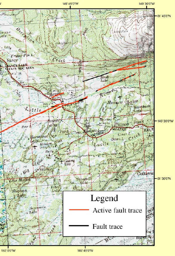
The map1
and GoogleEarth photo below indicate the location of the
fault as it passes through Houston. This fault is the
only one known in the greater Anchorage, Alaska, area, with
historical seismicity and a Holocene (created within the past
11,500 years) fault scarp ("cliff" produced by faulting
rather than erosional forces). The fault is considered
capable of producing a magnitude 6.9 to 7.3
earthquake2 sometime during the near
future.

The Castle Mountain fault
is a right lateral strike-slip fault that runs east-northeast along
its 200 km length. The term strike-slip means the plates (land
masses) on opposite sides of the fault move horizontally.
"Right lateral" means the plate on the side of the fault opposite
the observer moves to the right when the fault slips. An
animation of a strike-slip fault and other types of faults may be
found by clicking here.
The fault is observed
easily from the air because of a prominent change in vegetation on
the upthrown, north side of the fault. Seismologists dug
trenches across the fault at several locations to learn how often
and how much the fault slips when it triggers an earthquake.
The scientists determined that the Castle Mountain fault has
slipped three times in the past 2145 years: 2145–1870,
1375–1070, and 730–610 years before present (B.P.), indicating an
average recurrence interval of ~700 years. Given that it has
been 610 to 730 years since the last significant earthquake
caused by this fault, a significant earthquake may occur in the
near future. The dates are given in ranges due to the
uncertainty in dating sedimentary and dead vegetative evidence
found at various levels in the trenches. One interesting
aspect of Castle Mountain fault earthquakes is that they all appear
to have occurred during April to October due to evidence of ground
liquifaction (movement of water saturated soils when shaken) which
indicates the ground was not frozen during the
events.3
Seismologists
identified a postglacial (created after the pre-Holocene glaciers
retreated) outwash channel that has been offset by approximately 36
meters during the past 12,400 years due to ongoing fault
slippage3. In recent times, the fault produced
light to moderate magnitude 5.7 and 4.6 earthquakes in 1983 and
1996, respectively.4 Did these quakes relieve some
of the strain along the fault or did they serve to "wind the
clockspring" at another location? Only time will
tell.
For more
information about Alaskan earthquakes and earthquake preparedness,
visit the Alaska Earthquake Information
Center website.
To receive credit for
this cache, e-mail the answers to the following
questions. Logs not followed up by an e-mail will be
deleted.
-
The past is often a predictor for future events
along faults. Using the average fault movement per year after the
glaciers retreated, how much would you expect the fault to move
during the next major siesmic event?
-
Walk between N61° 37.324' W 149° 47.329'
and N61° 37.326' W 149° 47.309', and determine and report the
height of the tallest scarp (vertical surface expression of the
fault) that you observe. Why do you think the scarp is taller
at that location?
-
Why isn't the fault readily apparent along its
entire 200 km length? (What ongoing natural phenomenon is at
work?)
1GIS Coverages
of the Castle Mountain Fault, South Central Alaska, Keith Labay and
Peter J. Haeussler, U.S. Geological Survey Open-File Report 01-504,
http://pubs.usgs.gov/of/2001/of01-504.
2Holocene Slip Rate for the Western
Segment of the Castle Mountain Fault, Alaska, Julie B. Willis,
Peter J. Haeussler, Ronald L. Bruhn and Grant C. Willis,
Bulletin of the Seismological Society of America; June
2007; v. 97; no. 3; p. 1019-1024; DOI: 10.1785/0120060109 © 2007
Seismological Society of
America, www.bssaonline.org/cgi/content/abstract/97/3/1019.
3Paleoseismology at high latitudes:
Seismic disturbance of upper Quaternary deposits along the Castle
Mountain fault near Houston, Alaska, Geological Society of America
Bulletin, Article: pp. 1296–1310, Volume 114, Issue 10 (October 2002), Peter
J. Haeussler, Timothy C. Best, and Christopher F.
Waythomas.
4USGS Study
Shows that Anchorage Area Fault is Capable of a Large Quake, U.S.
Geological Survey News Release, Oct. 23, 2002,www.scienceblog.com/community/
older/archives/E/usgs308.html.
The
Geological Society of America (GSA) EarthCache Project - Learn
about the EarthCache Master Program: earn
Bronze/Silver/Gold/Platinum status, with an EarthCache Master Pin
awarded at each level!