The Knobs Region of Kentucky EarthCache
The Knobs Region of Kentucky
Please note Use of geocaching.com services is subject to the terms and conditions
in our disclaimer.
Listed coords will take you to a scenic hill-top (knob-top?) in Knob's State Forest.
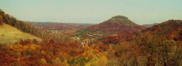
"The Knobs" is the physiographic region that borders the Outer Bluegrass. It consists of hundreds of isolated, steep sloping, often cone-shaped hills . In physiographic terms, the hills are monadnocks or erosional remnants. They were originally continuous with the Mississippian Plateau, but were separated from the plateau by stream erosion. Many of the knobs are still capped by erosionally-resistant limestones or sandstones. The sharp slopes of the Knobs are mostly composed of shales of the Mississippian-age Borden Formation, which are less resistant to erosion than the overlying limestones and sandstones. The base of the Knobs commonly contain Devonian black shales . The Knobs physiographic region occurs along the outcrop belt of the Devonian-Mississippian contact. The knobs are usually associated with the outcrop belt of Silurian and Devonian rocks which commonly crop out nearby. Bernheim Forest (south of Louisville) and Berea, Kentucky are located in the Knobs Region.
To log this Earthcache you must take and post a photo of you and your GPS at the "V" tree with the rock cairn at the bottom
In addition you must answer these questions by E-mail only.
1. What geological force created these knobs?
2. What is buried under the rock cairn ?
Remember to take nothing from the hilltops and leave only your footprints.
Jeepstaff & Buddy.
Additional Hints
(No hints available.)
Treasures
You'll collect a digital Treasure from one of these collections when you find and log this geocache:

Loading Treasures