
It's hard to imagine The Continental Ocean (depiction) being in the Ohio Valley, but it's even harder to visualize thousands of plants and animals living in and on a coral patch reef complete with a white sand beach.
The fossil beds at the Falls of the Ohio are the remains of a fossil coral reef. A typical coral reef consists of hundreds or thousands of intergrown coral colonies. Each coral colony consists of thousands or millions of soft polyp animals.
There are a variety of different types of reefs. Reefs are formed in shallow marine (salt water) environments. The reef ecosystem has never existed in fresh water. They are built upon the skeletal remains of earlier organisms. Reefs need not be made up of corals at all. In the past some reefs were made from echinoderms (like crinoids), clams, sponges, brachiopods and other skeleton- producing animals.
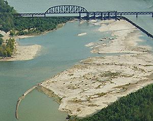
The most well-known type of reef is a barrier reef. Barrier reefs can be enormous. They form parallel to coast lines. Australia's Great Barrier Reef is more than 2,000 miles long. Other types of reefs include atolls, apron reefs and patch reefs(photo).
Atolls, fringe submerged volcanoes. Apron reefs form on shallow undersea slopes, away from land masses. A patch reef (or bioherm) forms mounds of isolated coral colonies.
The coral bed at the Falls is a patch reef. It stretched some 1,000 miles in length, was probably hundreds of miles wide and can be found in similar rocks in Columbus, Ohio, near Buffalo, New York and in southern Ontario.
Life existed here 425, 387, and 380 million years ago, respectively, during the Middle Silurian (Louisville Limestone), lower Middle Devonian (coral zone of the Jeffersonville Limestone) and upper Middle Devonian (North Vernon Limestone) periods.
That span of time represents an amazing 50 million years!
Tropical reef environments have always shared similar characteristics, including warm water, high angle of solar radiation and similar meteorological conditions. Coral reefs are only found between 27 degrees north and south of the equator (roughly between the Tropic of Cancer and the Tropic of Capricorn).
Coral does not grow well in cool water and therefore does not form reefs outside of the tropics.
Corals dominate the Louisville and Jeffersonville Limestone scenes, but are less important in the North Vernon Limestone where brachiopods and crinoids are more numerous. The Silurian rocks are characterized by over 150 fossil species. The Devonian (both Jeffersonville and North Vernon Limestone) contain over 450 species. The diorama recreates nearly 200 species of fossils. This is a small representation of the living ecosystem, where only a minute number of organisms were actually preserved. Scientists estimate only one percent of the species of plants and animals are preserved as fossils.
The Silurian rock is dominated by the chain coral called Halysites. Individuals forming the colony are linked together like a chain, hence its nickname. Other colonial corals, horn corals and sponges (the biggest are called stromatoporoids) make up this coral / stromatoporoid bioherm, or patch reef.
This site is best accessed by boat.

IF YOU HIKE - BEFORE YOU GO:
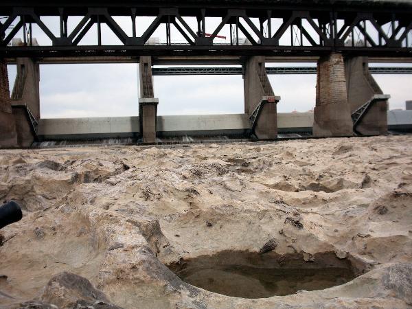
Call this number 502.775.5056 and listen to the one-minute recording. It will give you important information on the river level above and below McAlpine dam. You will also hear how much water is running through the upper and lower spillways of the dam (one-mile apart).
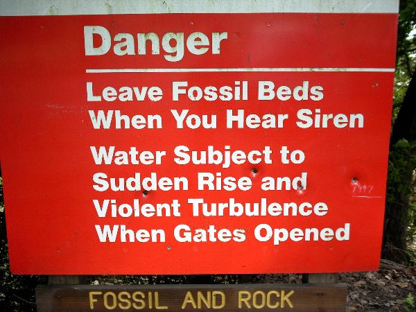
If there is any water running through the upper dam spillway, this hike is NOT POSSIBLE - YOU CANNOT CROSS ANY WATER AT THE UPPER SPILLWAYS!
When the upper gauge is at pool, the level will be ~12.0 feet. The lower gauge (below the dam) MUST be 12.0 feet or LESS also.
If the lower gauge is above 20 feet, the reef will be submerged.
UNDERSTAND the three-day forecast from the National Weather Service! It will advise the trend of the lower river level. If the forecast is for a rising river, beware!
The river level can change quickly with very little notice!
HIKE THIS CACHE ON A STATIONARY OR FALLING FORECAST ONLY! If the forecast is for a RISING river, you will be trapped if the upper spillway gates are opened.
When there is to be a change in gate position and water flow/level, there will be a CONTINUOUS SOUNDING OF THE SIREN. ONCE THE SIREN GOES SILENT, THERE WILL BE A SHORT PAUSE BEFORE THE SPILLWAY GATES RAISE (or lower, do you remember the forecast?)
Be aware that once you are across, you are in no man's land.

Map of reef at 10-foot lower gauge. Red dotted line is a route
LOGGING REQUIREMENTS
Take a pic (optional) of yourself or your GPSr at the coordinates and answer these four questions:
1. What is a patch reef made up of?
2. Coral reefs are only found where in relation to the equator?
3. Name two of the four types of reefs discussed here.
4. What is the estimated height of the gate structure at Patch Reef Beach?
Note: The Ohio River is part of the state of KENTUCKY but the falls are best viewed from Clarksville, IN.
Email answers to ARF! at this address:
AirRaidFan@aol.com
Please email your answers first, then LOG THE FIND. Do not wait on a reply from me. FINDs which do not meet logging requirements will be removed.