Hills and Holes
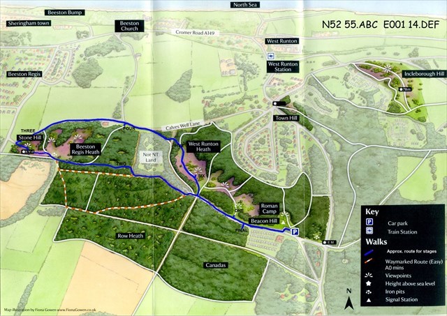
A multi cache based at Roman Camp, between West Runton and Aylmerton.
The co-ordinates are for the car park, a charge of 50p is applicable or for free parking park at N52 55.473 E1 15.024
The first micro-cache can be found by solving the clues. The answers can be found using the new map / notice board at the car park
N52 55.ABC E001 14.DEF
A = "waymarked route (easy) A0 mins."
B = "Incleborough hill is 7B metres high"
C and D = "Telephone 01263 8374DC"
E = First number of the highest point
F = Stone Hill, first number minus the second
As the name of cache suggests this walk contain’s a few hills, and beware as Adder's are sometimes present in the area.
It was believed that the basin shaped depressions found on this site, and marked on early ordnance survey maps as 'Hills and Holes' were Hut circles a form of prehistoric dwelling, However excavations by Dr R E Tylecote in 1964 showed these were in fact dug out to provide the nodules of iron oxide used in the nearby smelting furnace, which would have proceed some 50 tons of metal from about 1,000 pits. The period the site operated was some time between AD 850 and 1150.
Beacon Hill, is the highest point in Norfolk and has been given many different names over the past few hundred years, in 1797 it was know as 'Old Beacon' or watch Tower, in 1826 Telegraph Station ,1838 Signal Station or Black Beacon hills, In 1816 Runton Signal House, 1840 it was known as Telegraph Dole, and since 1885 Beacon Hill. The earth banks visible today are the remains of a signal station dating back to the Napoleonic war.
You are looking for a white pot(s) similar size to a 35mm film cannister. The final cache is a regular sized clip and lock type box.
I have included a 'fall-back' cache, which gives the co-ordinates of all the stages. In each stage there is a letter (A to F) collect these numbers to give the final position.
At this position is a pot with co-ordinates written on paper as well as a blue NFC tag- this can be read by some phones or tablets (I set this up with a tablet, using the app NFC tools). You need to hold the NFC reader close by for a few seconds and the co-ordinates should be transferred over.
Note- Stage two co-ordinates
can also be obtained from the two benches, close by-
Look for 'Alec' and 'Peter'
for N52 55.LMN E001 RS.TUV
where:-
from 'Peter' L is the last number of the date, R is the first number of the
date, T is the second number of the date, U is the third number of the date,
V is same as U
from 'Alec' M is last number of line three, N is the last but one number of
line three, S is same as M
Note 'A' is the last two numbers on the third line of 'Sam' added together.