The Kentucky Exclave

The Kentucky Bend, variously called the New Madrid Bend, Bessie Bend or Bubbleland is an exclave of Fulton County, Kentucky.
In geography, an exclave is a country (state) or part of a country mostly surrounded by the territory of another country or wholly lying within the boundaries of another country.
This enclave is a piece of land on a hairpin turn of the Mississippi River and is completely surrounded by the states of Tennessee and Missouri.
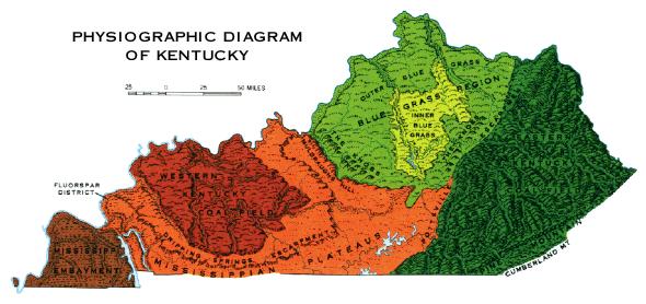
The Bend exclave lies in the Mississippi Embayment physiographic region of Kentucky and consists of alluvial deposits and loess. Loess (derived from glacial deposits) areas are geologically unstable by nature, and will erode very readily.
The 'neck' of the enclave once measured three miles but has been eroded to a width of less than a mile.
It is bounded by the Mississippi River, Ohio River, and Tennessee River (Pennyrile physiographic region) and includes the lowest elevation in the state.
The Kentucky Bend covers a land area of 17.5 sq mi and the only highway into the area is Tennessee State Route 22.
The exclave was created due to the shift in course of the Mississippi after the New Madrid Earthquakes in 1811 and 1812.
Surveyors marking the boundary between Kentucky and Tennessee had estimated where their line would meet the Mississippi. Later, more detailed surveys revealed the division of the loop. The western border of Kentucky is designated as the Mississippi River, as is the eastern border of Missouri — thus the creation of a 'notch' for Kentucky, but not for Tennessee.
The state of Tennessee contested the inclusion of the Kentucky Bend in the state of Kentucky, and it was legally part of Obion County, Tennessee, until at least 1848, but Tennessee eventually dropped its claim.
At the posted coordinates you will find a historical marker. The text on that marker is reproduced here:
COMPROMISE
Location: Kentucky-Tennessee line, KY 313
Description: To end Kentucky-Tennessee boundary dispute, Cox-Peebles survey began at Compromise, Ky., west of this point. Surveyors marked boundary eastward every 5 miles to Cumberland mountains. The 1858-59 line, for the first time, verified border to inhabitants, as well as to county and state officials. In 1860, Ky. and Tenn. recognized it as official boundary between the two states.
To claim this Earthcache as a find, please upload a photo of yourself or your GPSr at the marker at the Madrid Bend Families Cemetery (see mine below).


Additionally, to demonstrate the educational value of this earthcache, please email the answers to the following questions to ARF!.
Also, to demonstrate the educational value of this earthcache, please email me the answers to the following three questions:
1. The Bend was formed as a result of what?
2. The soil of the Mississippi Embayment physiographic region is comprised of what two deposits?
3. Up the road there is a cemetery with a white roadside marker. What are the four words at the top of this marker?
Please email your answers first, then LOG THE FIND. Do not wait on a reply from me. FINDs which do not meet logging requirements will be deleted.
 This Earthcache is hosted by a Platinum Earthcache Master!
See you out there!