This earthcache is intended to teach a little about Natural Springs.
A spring is a point where groundwater flows out of the ground, and is thus where the aquifer surface meets the ground surface. Depending on the constancy of the water source, a spring may be intermittent (ephemeral) or continuous (perennial).
As the water moves through the underground rocks, it collects minerals that become dissolved. This may give the water flavor and even carbon dioxide bubbles, depending upon the nature of the geology that the water passes through. Springs that contain significant amounts of these minerals are sometimes referred to as "Mineral Springs", and springs that contain large amounts of dissolved sodium salts, mostly sodium carbonate, are called "Soda Springs".
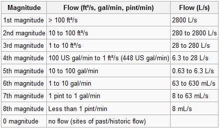
Springs are also classified by their flow rate, or water discharge, by the term Magnitude. The largest springs are called "First-Magnitude," and they are springs that discharge water at a rate of at least 2800 L/s. The scale for spring flow is as follows:
Jamestown Spring creates a pool of water before flowing over in to a small creek that passes through the park. This pool has been made slightly larger than it originally was by the Parks Department for aesthetic reasons, but the flow rate of the water still remains the same as it was originally. If you look carefully, you will see the spring bubbling through the dirt and gravel (the aquifer) and also see small ripples on the surface of the water directly above it.
To complete this earthcache you will need to bring a camera and thermometer with you.
Logging Requirements (Please email your answers for #2 thru #4 to us via our profile--Your photo MUST be uploaded with, and, at the time of your online log)
1. Post a picture of yourself or GPSr, and the spring clearly visible in the background with your online log. Do NOT send us the picture via the Messaging feature, it must be uploaded with your log.
2. Using your best guess, what magnitude do you think this spring would be classified as?
3. What is the temperature of the spring at the time of your visit? We used a pool thermometer and tossed it into the center of the spring pool.
4. What is the estimated width and depth of the spring pool?
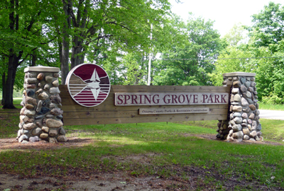
This cache has been placed with permission from the Ottawa County Parks and Recreation Department, and is located in Spring Grove Park.
Park Hours: 7 a.m. to 10 p.m. and is CLOSED in the winter months. ***Cache at your own discretion at that time.***
Anyone visiting the cache should be aware that the area is reserved at times for weddings and other ceremonies and should not enter the area when these ceremonies are taking place. If you will be visiting this cache and would like to be sure nothing is going on you can contact the Parks Department at the following:
Ottawa County Parks
12220 Fillmore St.
West Olive, MI 49460
Phone: (616) 738-4810
Toll-free: (Ottawa County Only) 1-888-731-1001 ext. 4810
Thank you for doing our first Earthcache!!!