This earthcache is designed to show you how today’s rivers are monitored/regulated. The above coordinates will take you to a United States Geological Survey (USGS) gage station for the Thornapple River in Hastings.
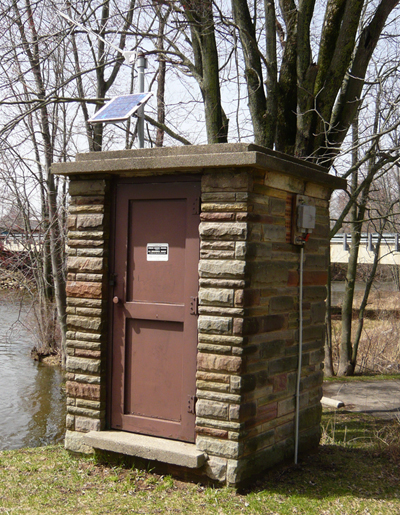
A Gaging Station is a facility used by hydrologists and others to monitor streams, rivers, lakes, canals, reservoirs, and other bodies of water. Gaging stations typically collect information such as water height and discharge (flow) through a stilling well or a vertical pipe that is located beneath the gage house. Water enters this well through one or more inlet pipes which in turn makes the water level equal to the stream or river. This information is recorded and sent to the USGS via telephone or a satellite communication system in real-time.
It is very important to monitor, and control the river’s flow for several reasons. We can start with the control of flooding or at least the warning of flooding. Another important reason for this gauging and regulating of the river is to limit erosion of the river banks. Even though erosion will always take place, it can be held to a minimal. Ground water also depends on these regulated flows. Ground waters include some small lakes, marshes and wetlands.
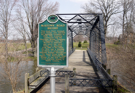
McKeown Road Bridge History
Depending on what side of the river you have parked, you may have to cross a short pedestrian bridge. There is a Michigan historical marker for it and it states:
“This steel Pratt through truss bridge was erected for Hastings Township in 1903. The township contracted with the Massillon Bridge Company of Massillon, Ohio, for $2,090, to fabricate and erect the steel bridge. In operation from 1869 to the 1930’s, the firm was a leading producer of metal truss highway bridges throughout the lower Great Lakes region. The McKeown Road Bridge is the last metal truss highway bridge in Barry County.”
Gaging Station History
In the 1880's, John Wesley Powell, the second director of the USGS, requested that stream flow be monitored in eight river basins in the West. It was his idea to measure the flow of streams and rivers and determine the viability of irrigation systems for this acrid region. In 1889, the first U.S. stream gaging station was established on the Rio Grande River in New Mexico. At this station, standard stream flow measurement procedures were devised.
Today, the USGS operates and maintains more than 85% of the nation's stream gaging stations. There are over 7,000 stream gaging stations in the United States, Puerto Rico, and the U.S. Territories of the Pacific Islands.
The USGS uses its stream gaging network to provide a free continuous source of well documented and archived water data. This data is used by government agencies and private companies to forecast flooding, design bridges, allocate drinking and irrigation water, for recreational use, and to manage our valuable surface water resources.
To find the information needed to log this cache, please visit the following website. Here you will find the Discharge (Flow) rate measured in cubic feet per second and also the Gage Height (Water Level) in feet.
Logging Requirements:
1. Post a picture of you or your GPSr and the gaging station in the background with your online log. Do NOT send us the picture via the Messaging feature, it must be uploaded with your log.
NO SCREENSHOTS PLEASE - SEND THE ACTUAL ANSWERS
2. E-mail what the discharge (flow) rate was at the time of your visit.
3. E-mail what the water level was at the time of your visit
*Please include the date and time of your visit in the email as well.
There is parking near the gaging station and also a picnic table to enjoy the views or even lunch.
Thank you for doing our earthcache!