[PT]
Mais uma multicache que vai da um pouco de trabalhinho para saber
as coordenadas finais ;)
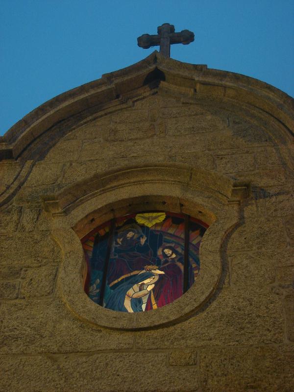
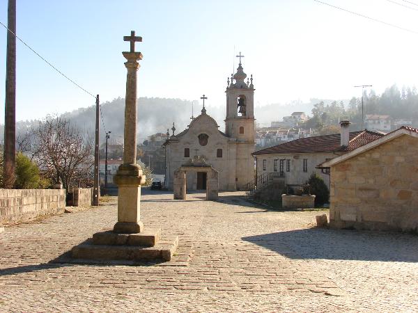
Esta é uma cache que vos leva a conhecer a Igreja Paroquial de
Pinheiro de Lafões (incluindo adro, cemitério e ponte
ferroviária).
Desde que vi morar para Pinheiro de Lafões, o local que me atraio
mais foi esta Igreja e a zona envolvente. Mais uma bom exemplo de
uma Igreja de pedra, bem bonita por sinal. Recomenda-se a visita
nocturna, pois toda a zona está iluminada, as não deixem de entrar
para ver belo interior.
Deixe o carro em N 40° 43.537 W 008° 12.750 e siga a pé os
últimos metros. Continue pelo caminho de terra em direcção à ponte
o comboio. Antes de chegar à ponte, tome o caminho da esquerda e
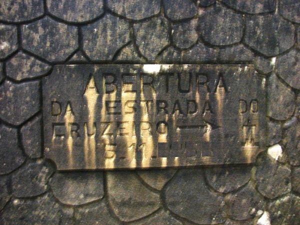
passe por baixo da ponte do comboio, até às coordenadas N 40°
43.536 W 008° 12.822 onde estão 3 placas. Duas delas têm datas
necessárias para as coordenadas finais (ler abaixo).
Volte à ponte e atravesse a ponte em direcção à Igreja. Esta ponte
é um dos muitos vestígios da antiga linha do Vouga, existindo ainda
um carril e várias travessas ao longo da sua extensão.
Ao chegar ao adro da Igreja, recolham os dados abaixo indicados.
Espero que gostem do local.

Coord finais da cache: 40º4A.BCD’
8º1E.FGH
A – Número de cruzes de pedra no telhado da Igreja (não contar com
a da torre);
B – Número de degraus da torre da Igreja - 11;
C – No pórtico em pedra frente à Igreja, o número de folhas
(do baixo relevo) que está por baixo da cruz –
10;
D – Na data que a Igreja tem por cima da porta e ramo ao pé da data
(abcd), D=a+b-(nº de folhas do ramo)-4;
E – Número de janelas com 4 vidros na torre da Igreja +
1;
F – Número de oliveiras com um vaso pendurado no complexo da Igreja
+ 1;
G – Número de arcos da ponte do comboio - 2;
H – Nas coord N 40° 43.536 W 008° 12.822: H=( ano da placa da
esquerda )-( ano da placa da direita ) - 1;
[ENG]
This is one multicache that is going to give you
a little work to get the final cache coordinates
;)
This cache takes you to Parochial Church of
Pinheiro de Lafões (including churchyard, cemetery and
Railway Bridge).
Since I came to leave in Pinheiro de Lafões, the
place that attracts me the most was the Church and the
surrounding area. This is one good example of a typical stone
church in this region. I recommend a night visit, because the
zone is very well illuminated. Do not forget to look inside
the Church for a moment.
Leave the car in N 40° 43.537 W 008°
12.750 and walk the last meters. Continue through the
dirt road to the railway bridge. Before reaching the bridge,
turn left to a road that passes below the bridge and go to
the coordinates N 40° 43.536 W 008° 12.822 where 3
stone plaques. Two of them have dates needed in the final
coordinates (read below).
Go back up to the bridge and cross it in
direction of the Church. This bridge is one of the remains of
the old Vouga railway line, where you can still see a rail
and many sleepers.
When you reach the churchyard, look for the data
requested below. I hope that you like the place.
Final cache coordinates:
40º4A.BCD’ 8º1E.FGH’
A – Number of stone crosses on the roof of the
Church (don’t count the bell tower);
B – Number of steps of the bell tower -
11;
C – On the stone portico in front of the Church,
the number of leaves (on the low relief) that are below the
cross – 10;
D – Regarding the data that is above the Church
doorand the branch that is near, D=a+b-(number of
leaves)-4;
E – Number of windows with 4 glasses in the bell
tower + 1;
F – Number of olive trees with one hanged vase
around the Church + 1;
G – Number of arcs that the train bridge has
- 2;
H – In the coordinates N 40° 43.536 W 008°
12.822, H=( year of the left plaque )-(
year of the right plaque ) - 1.