Geschichte:
Am Reschenpass gab es bis zur Seestauung 1950 drei Seen: Den
Reschensee, den Mittersee (auch Grauner See genannt) und den
Haidersee. Bei der Seestauung wurde das gesamte Dorf Graun und ein
Großteil des Dorfes Reschen in den Fluten des Stausees versenkt.
163 Häuser wurden zerstört und 523 Hektar an fruchtbarem
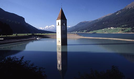
Kulturboden wurden überflutet. Heute zeugt nur noch der aus dem
Reschensee ragende Kirchturm vom versunkenen Alt-Graun. Es entstand
ein riesiger Stausee mit 677 ha Fläche, welcher eine fast
tausendjährige Besiedelungsgeschichte und eine einmalige Kultur-
und Naturlandschaft, die Hochebene am Reschenpass, mit Gewalt
vernichtet hat. Im Jahr 1939 wurde das erste italienische Projekt
aus dem Jahr 1920 zur Aufstauung der Naturseen (Reschen- und
Mittersee) um fünf Meter durch die damalige faschistische Regierung
auf 22 Meter (+ 17 Meter) abgeändert. Dies geschah ohne jegliche
Information der Bevölkerung und ohne jegliche rechtliche oder
ökologische Prüfung. Die Einwohner wurden im „nationalen
Interesse zur Stärkung der nationalen Industrie“
zwangsenteignet, ohne Recht auf Realersatz, und zur Aus- oder
Umsiedlung gezwungen. Der Zweite Weltkrieg verzögerte die
Bauarbeiten. Finanzierungsschwierigkeiten der Betreibergesellschaft
nach Kriegsende wurden von Schweizer Kapitalgebern aufgefangen.
1949 musste der erste Winterstrom als Kapitalrückzahlung in die
Schweiz geliefert werden. Südtirol und die betroffenen Gemeinden
waren machtlos. Wegen des faschistischen Regimes hatten die
Gemeinden von 1923 bis 1952 keine gewählten Volksvertreter.
Im Sommer 1950 waren die gesamten Gebäude gesprengt und überflutet,
die Bewohner entweder zwangsausgewandert oder für zwei Jahre in ein
Barackendorf umgesiedelt. Der romanische Turm aus dem 14.
Jahrhundert wurde aus Gründen des Denkmalschutzes stehen
gelassen.
In den Jahren nach 1973 hat die Südtiroler Landesregierung
umfangreiche Sanierungsmaßnahmen durchgeführt. Zirka 35 ha
Kulturfläche sind mit Material aus dem Stausee zurückgewonnen
worden.
Folgen:
• 70 % der Bevölkerung ist aus- oder abgewandert
• 181 Wohnhäuser bzw. landwirtschaftliche Gebäude wurden
gesprengt
• 523 ha Kulturfläche sind verloren gegangen
• 70 % weniger Nutztiere
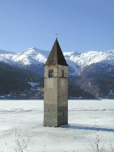
Der Turm: Der Großteil des Kirchturmes des Ortes ragt
heut noch aus dem Staussee. Im Winter, wenn der See zugefroren ist,
kann man ihn zu Fuß erreichen. Der Legende nach kann man im Winter
die Glocken des Turmes läuten hören. (In Wirklichkeit sind die
Glocken am 18. Juli 1950, eine Woche vor dem Abbau der Kirche und
der Überflutung, abmontiert worden.)
History:
In July 1939, the Montecatini company (now Edison Energia)
introduced a new plan for a 22-meter deep lake, which would unify
two natural lakes (Lake Resia and Lake Graun) and submerge several
villages, including Graun and part of Reschen. The creation of the
dam started in April 1940, but due to the war and local resistance,
did not finish until July 1950. Ironically, in 1947 Montecatini
received 30 milion Swiss Francs from the Swiss company Elektro-Watt
for the construction of the dam (in exchange for 10 years of
seasonal electricity) after the local population had voted against
the company's plans to build a dam that would have submerged the
Swiss village of Splügen. Graun's population did not have such
success, despite a willing ear of Antonio Segni who would later
become Italy's prime minister, and in total 163 homes and 523
hectares of cultivated land were submerged. The location had been
inhabited since Roman times.
The tower: The top of the 14th-century church tower, now
an apparent campanile, is still visible. In winter, when the lake
freezes, the campanile is reachable by foot. A legend says that
during the winter one can still hear church bells ring (in reality
the bells were removed from the tower on July 18, 1950, a week
before the demolition of the church and the creation of the
lake).
Storia:
Presso il passo di Resia si trovavano tre laghi naturali: il lago
di Resia, il lago di Curon detto anche lago di Mezzo (ted. Grauner
See o Mittersee) e il lago di San Valentino alla Muta. La creazione
di una grande diga nel 1950 unificò i primi due precedenti laghi e
sommerse l'antico abitato di Curon Venosta che venne ricostruito
più a monte. 163 case e 523 ettari di terreno coltivato a frutta
furono sommersi. Se ne ricavò il bacino dell'attuale lago, lungo 6
Km e largo 1 Km nel punto di massima larghezza.
L'idea di sfruttare questi tre laghi per la produzione di energia
idroelettrica risale all'anno 1910, ma solo nel 1920 furono
presentate le relative domande per la concessione. Nel 1923 la
stessa società che richiese la concessione (Comitato Promotore
della Società Elettrica Alto Adige) entrò a far parte del gruppo
Montecatini. I lavori inizarono nel '39, ma per l'inizio della
guerra, i lavori furono rallentati e poi sospesi nel '43. Nel '46
nonostante la difficoltà economica del dopo guerra, e la mancanza
di tutte le materie prime necessarie alla continuazione dell'opera,
i lavori furono ripresi ed ultimati con l'inaugurazione il 28
agosto 1949. Naturalmente le dificoltà più grandi si ebbero per la
mancanza delle indispensabili materie prime. Fu infatti importata
per la prima volta della glicerina dall'Argentina per poterla usare
come esplosivo. Fu inoltre portato il legname dalla Sila ed il
cemento con i camion e convogli ferroviari dal nord Italia.
Ai lavori parteciparono 7.000 operai, per mille giornate
lavorative, con un costo di 25 miliardi di lire. In totale furono
scavati 35 chilometri di tunnel sotterranei, ed utilizzati un 1,5
milioni di quintali di cemento, 10.000 t di ferro e 800 t
d'esplosivo. Ma il costo più elevato fu quello di dover radere al
suolo completamente il centro abitato di Curon Venosta, e
parzialmente quello di Resia, che vennero ricostruiti in posizioni
più elevate.
La vecchia chiesa di cui fa parte il campanile fu costruita verso
la metà del 1300. La creazione della diga accese vive proteste tra
gli abitanti del luogo, i quali interpretarono ciò come un gesto di
sfregio del governo di Roma nei confronti dei sudtirolesi. Questi
si recarono addirittura dal Sommo Pontefice per scongiurare la
realizzazione dell'opera, ma ciò non servì.
Il campanile:La cima del vecchio campanile di Curon
(Graun) emerge dalle acque ed è tuttora visibile. In inverno,
quando il lago gela, il campanile è raggiungibile a piedi. Una
leggenda racconta che in alcune giornate d'inverno si sentano
ancora suonare le campane (che invece furono rimosse dal campanile
prima della creazione del lago).
DER CACHE:
Der Cache ist eine 4*8*2 cm große Box.
THE CACHE:
The cache is a box of approx. 4*8*2 cm.
LA CACHE:
La cache è una scatoletta di ca. 4*8*2 cm.
FOTO: Ein Foto vom Turm wäre fein! Una foto della torre
sarebbe bello! A picture of the tower would be nice!