The Little River flows for most of its
length atop Lookout Mountain in northeast Alabama. Over many
millions of years, the river has cut into the heart of Lookout
Mountain to create this canyon. Little River Falls is just upstream
form the head of Little River Canyon, one of the deepest - and most
beautiful - canyons east of the Mississippi.
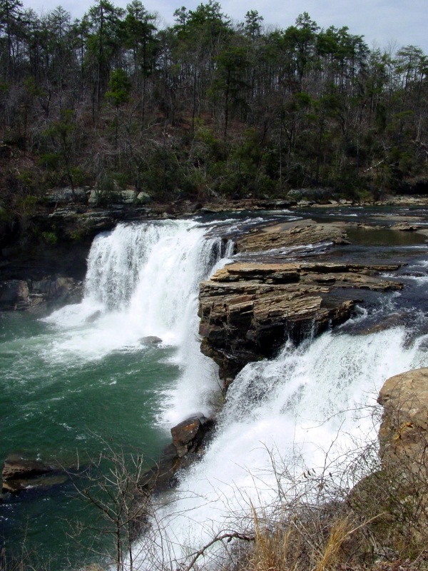
Little River Falls is located off Highway
35 next to the bridge in Gaylesville, Alabama (the bridge is the
boundary between Gaylesville and Fort Payne). This is the first
stop to make on your scenic tour of the park entering from the
north. The formation of Little River Canyon begins here. A paved
semi-steep trail leads to an overlook of the falls. The amount of
water going over the falls depends on the amount of rainfall. In
the winter and early spring the water level is high. Kayakers love
this time of year because they can kayak the river. The water level
is low in the summer and fall. No matter the season: Little River
Falls is a very beautiful place to visit.¹
Waterfalls
Area where flowing river water drops
abruptly and nearly vertically. Waterfalls represent major
interruptions in river flow. Under most circumstances, rivers tend
to smooth out irregularities in their flow by processes of erosion
and deposition. In time, the long profile of a river (the graph of
its gradient) takes the form of a smooth curve, steepest toward the
source, gentlest toward the mouth. Waterfalls interrupt this curve,
and their presence is a measure of the progress of erosion. A
waterfall may also be termed a falls or sometimes a cataract, the
latter designation being most common when large volumes of water
are involved. Waterfalls of small height and lesser steepness
are called cascades; this term is often applied to a series of
small falls along a river. Still gentler reaches of rivers that
nonetheless exhibit turbulent flow and white water in response to a
local increase in channel gradient are called rapids.
There are several conditions that give
rise to waterfalls. One of the most common reasons for a
waterfall's existence is difference in rock type. Rivers cross many
lithological boundaries, and, if a river passes from a resistant
rock bed to a softer one, it is likely to erode the soft rock more
quickly and steepen its gradient at the junction between the rock
types. This situation can occur as a river cuts and exhumes a
junction between different rock beds. The riverbed of Niagara
Falls, which forms part of the boundary between the United States
and Canada, has a blocky dolomite cap overlying a series of weaker
shales and sandstones.
A related cause of waterfalls is the presence of bars of hard
rock in the riverbed. A series of cataracts has been created on the
Nile where the river has worn its bed sufficiently to uncover the
hard crystalline basement rock.
Other waterfalls are caused less by the character of rock
formations and more by the structure or shape of the land. Uplifted
plateau basalts, for example, may provide a resistant platform at
the edge of which rivers produce waterfalls, as occurs on the
Antrim basalts in Northern Ireland. On a much larger scale, the
morphology of the southern half of Africa, a high plateau
surrounded by a steep scarp slope, creates waterfalls and rapids on
most of the area's major rivers. These include the Livingstone
Falls on the Congo River and the Augrabies Falls on the Orange
River. In general, the occurrence of waterfalls increases in
mountainous terrain as slopes get steeper.
Erosion and geology are not the only factors that create
waterfalls. Tectonic movement along a fault may bring hard and soft
rocks together and encourage the establishment of a waterfall. A
drop in sea level promotes increased downcutting and the retreat
upstream of a knickpoint (sharp change of gradient indicating the
change of a river's base-level). Depending on the change of sea
level, river flow, and geology (among other factors), falls or
rapids may develop at the knickpoint. Many waterfalls have been
created by glaciation where valleys have been over-deepened by ice
and tributary valleys have been left high up on steep valley sides.
In the glacially gouged Yosemite Valley in California, the Yosemite
Upper Falls tumble 436 m (1,430 feet) from such a hanging
valley.
Within a river's time scale, a waterfall is a temporary feature
that is eventually worn away. The rapidity of erosion depends on
the height of a given waterfall, its volume of flow, the type and
structure of rocks involved, and other factors. In some cases the
site of the waterfall migrates upstream by headward erosion of the
cliff or scarp, while in others erosion may tend to act downward,
to bevel the entire reach of the river containing the falls. With
the passage of time, by either or both of these means, the
inescapable tendency of rivers is to eliminate any waterfall what
may have formed. The energy of rivers is directed toward the
achievement of a relatively smooth, concave upward, longitudinal
profile.
Even in the absence of entrained rock debris, which serve as an
erosive tool of rivers, the energy available for erosion at the
base of a waterfall is great. One of the characteristic features
associated with waterfalls of any great magnitude, with respect to
volume of flow as well as to height, is the presence of a plunge
pool, a basin that is scoured out of the river channel beneath the
falling water. In some instances the depth of a plunge pool may
nearly equal the height of the cliff causing the falls. Plunge
pools eventually cause the collapse of the cliff face and the
retreat of the waterfall. Retreat of waterfalls is a pronounced
feature in some places. At Niagara, for example, the falls have
retreated 11 km (7 miles) from the face of the escarpment where
they began. Today much of Niagara's water is diverted for
hydroelectric power generation, but is has been estimated that with
normal flow the rate of retreat would be about 1 m (3 feet) per
year.²
Types
of waterfalls
-
Block:
Water descends from a relatively wide stream or river.
-
Cascade: Water descends a series
of rock steps.
-
Cataract: A large water
fall.
-
Fan: Water spreads horizontally
as it descends while remaining in contact with bedrock.
-
Horsetail: Descending water
maintains some contact with bedrock.
-
Plunge: Water descends
vertically, losing contact with the bedrock surface.
-
Punchbowl: Water descends in a
constricted form, then spreads out in a wider pool.
-
Segmented: Distinctly separate
flows of water form as it descends.
-
Tiered: Water drops in a series
of distinct steps or falls.
-
Multi-step: A series of
waterfalls one after another of roughly the same size each with its
own sunken plunge pool.
REQUIREMENTS
Please
DO NOT give away any information in your logs. Email me
the answers to the following
questions.
-
How high is Little River
Falls?
-
Name 2 of the 3 layers of rock this canyon was
carved out of.
-
What was the name of the bustling
community that was part of the Little River Falls
area?
-
What type of falls do you think this is?
Finally you MUST take
a picture of yourself and your GPS at the listed coordinates with
the falls in the background and include it with your
log.
An added
note:
A paved semi-steep trail
leads to an overlook of the falls so if you are travelling by
wheelchair I would up the terrain level to a 2 - 2.5
Permission was granted
to place this EarthCache.
1.
National Park Service
2. waterfall. (2008). In Encyclopaedia
Britannica. Retrieved June 14, 2008, from Encyclopaedia Britannica
Online: http://www.britannica.com/eb/article-9076251