Alum Bay is famous for its coloured sands, chalk Sea Stacks called "The Needles" and lighthouse. It is a designated area of outstanding natural beauty. It also has fold features, showing both vertical and horizontal rock folds.
The principal routes to the beach are the chair-lift (fee applies) or steps which lead down to the beach from within the 'Needles Park' (clearly signed in the park).
The geology of Alum Bay tells a story of massive biological and physical change spanning 50 million years. The northern and middle sections of the bay are made of Eocene sediments, deposited in a shallow, warm sea between 35-54m years ago whereas the southern end comprises towering chalk cliffs, deposited in deeper water around 80m years ago.
The rocks either side of the chair lift show the different fold features, on the Southern side the strata are vertical whereas those on the Northern side are horizontal. The vertical strata make changes in colour more striking when walking along the beach.
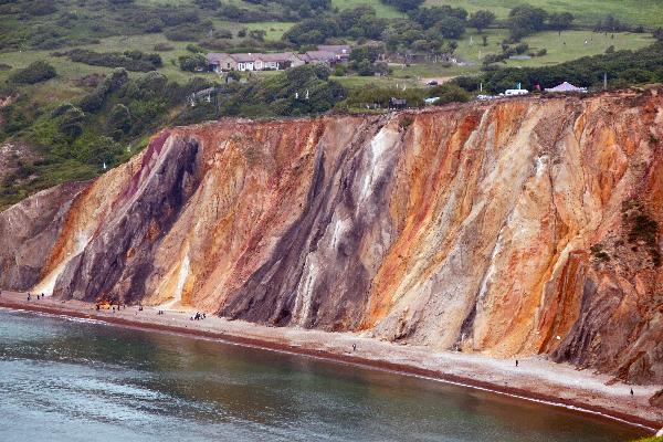
The sands are largely derived from the Bracklesham Group, located along the middle sections of the bay. Although the sediments were originally lying horizontally, the pressure of continental movement over millions of years has resulted in localised folding, which is now evident by the vertical position of the beds.
The lower part of the Bracklesham Group is the Poole Formation which includes sands, grey clays with plant debris, lignite beds and pipe clay. The pipe clay is a kaolinite-illite clay, more plastic than the kaolinite china clays of Devon and Cornwall. The Poole Formation is non-marine and was deposited in the Poole Delta, the discharge area of a large river coming from the Dartmoor region. Although at a latitude of about 40 degrees north this was quite a hot delta, almost subtropical, because the Paleocene-Eocene was a time of greenhouse type, global warming. The almost tropical weathering beneath the dense forests led to much release of iron. The abundance of iron in this relatively high latitude, but subtropical-type delta is ultimately responsible both the for bright colours of the sands, and also for the pyrite from which Alum Bay (indirectly) takes its name.
Natural sulphates occur in the cliffs of Alum Bay as a result of oxidation of pyrite. These form different compounds depending on the other material present resulting in change to the colour of the quartz sands. The list below shows how specific colours can be produced:
- White can come from pure quartz sands
- Green is provided by glauconite which is common in marine material such as the Barton Clay
- Black can come from Lignite (this is a form of poor quality coal)
- Bright yellow might be obtained from Jarosite
- Yellow and brownish sands owe their colour to limonite (or goethite) which is ferric hydroxide (effectively rust)
- Red colours often indicate early oxidation, a process which occurs in ancient soils.
In order to log this cache please go to the posted co-ordinates and:
1. Send me a message listing the colours that you can see and what causes each of these colours, and ALSO
2. Find the white vertical strata which stands proud between yellow and red rock. Estimate the width of the white section and message this answer to me, and ALSO
3. Take a photo of your caching name with the coloured sands in the background and post this with your log (an alternative to this is to take a Selfie with the coloured sands).