|
 |
|
|
Cherokee Park Big Rock |
|
The area surrounding Cherokee Park’s Big Rock has long been
referred to as the
Highlands. The reason
for this name is a result of the underling rock structure of this
part of Louisville. The
limestone rock layers slope up toward the east from downtown
Louisville at about 20 feet or more per
mile. The Louisville
and Jeffersonville limestones are about 130 feet higher at Hogan’s
Fountain in Cherokee Park than they are at the Falls of the
Ohio. This along with
the fact that the limestone bedrock has been eroded down in the
valley by the Ohio River and torrents of meltwater from Quanternary
period glaciers helps explain why the Highlands sit well above
downtown Louisville.
Long before Big Rock came to be, this area of the Highlands was
entrenched by Beargrass creek to form the cliffs and valley we see
today.
Although the primary water drainage in this area is on the surface,
there is a substantial amount of subsurface drainage activity
including springs found along the creek and surrounding
area. Louisville
limestone is not the best for cave development, but it does allow
for some karst activity on a smaller scale.
|
 |
|
|
Geologic Map of Cherokee Park |
|
To get to Big Rock you will need to follow the lower trail near the
creek. No rock climbing
is required on this
trail. The trail
however is uneven, can get muddy, is narrow in spots, and the
exposed tree roots can present a slipping hazard. Parking is
available near the Big Rock Pavilion at N38 13.961 W085
40.936.
Big Rock Pavilion – N38 13.952 W085 40.980
This historic pavilion was built as part of the park improvements
envisioned by Fredric Olmsted the designer of Cherokee
park. The shelter was
built on Alluvium. This
material from the Quaternary geologic period is composed mainly of
a mixture of silt, clay, sand, and
gravel. This glacial
outwash material is typical of low lying areas near creek beds in
Louisville. The Big
Rock trail starts at the edge of the woods just downstream from
this pavilion.
Beargrass Creek – N38 13.967 W085 41.006
This is the Middle Fork of the Beargrass Creek watershed which is
the largest in Jefferson County draining over 60 square
miles. The Middle Fork
joins the South Fork and then the Muddy fork before dumping into
the Ohio River near Towhead
Island. Notice that the
creek in this area flows across a solid bed of Louisville
limestone. The
elevation here is about 450 feet above sea level.
Occluded Spring – N38 13.960 W085 41.023
The first spring you encounter at the beginning of the trail is
located just 5 feet off the
trail. This is an
occluded Karst spring.
This type spring really does not issue from an opening but appears
to be seeping right out of the ground.
Small Cave Spring – N38 13.959 W085 41.29
Just 30 feet up the trail is a small Cave
Spring. Water here
flows out of a bedding plane in the Louisville
limestone. A bedding
plane is the contact area between two depositional layers of
sedimentary rock. This
usually appears as a horizontal joint or
crack. Water tends to
take the easiest route and as it seeps down through the ground and
it will find and utilize these bedding
planes. Over time water
flowing through the crack continues to enlarge it and eventually a
cave is formed. The
cave to the right of the spring actually extends back for more than
20 feet but is only about 2 feet high or less for most of that
distance. Shortly past
the spring the trail splits and you will need to take the lower
trial. |
 |
Small Spring & Cliffs –
N38 13.973 W085
41.054
This is a small ephemeral fracture type spring that flows out of a
3 inch bedding joint about 8 feet above the
trail. It mainly flows
following rain but will continue to dribble water for even longer
periods during the wetter time of the year. If you look carefully
to the left of this spring you might spot some fossil fragments in
the limestone.
Unfortunately there is not an abundance of fossil material exposed
in this limestone. This
spot also marks the beginning of a 150 foot long Louisville
Limestone cliff. There are a total of 4 weeping springs located
along this stretch of cliff line.
Small Spring
– N38 13.980 W085
41.060
This is another small ephemeral spring that flows out of a 3 inch
bedding joint about 8 feet above the
trail. Notice the Algae
and tufa deposit along the wall below the
spring. Tufa is
deposited calcium carbonate that had been previously dissolved in
the spring water as it passed down through soil above the
limestone. When the
spring water hits the fresh air the carbon dioxide levels in the
water drop allowing the calcium carbonate to precipitate out
forming this coating on the rock. |
 |
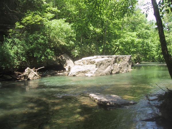
Big Rock – N38 13.994 W085 41.069
This big giant came to rest in the creek after it broke away and
fell from the nearby Louisville limestone cliff many years
ago. No one knows for
sure when or how this
happened. Who knows
maybe it’s fall could have been helped along by frost wedging or
earthquake activity.
What is known is that Big Rock has long been a popular destination
for sightseers, picnickers, and swimmers. Through out the decades
Big Rock has provided a good platform to jump from into the 6 foot
deep water below. Unfortunately because of potential pollution
during certain times, swimming is now discouraged but wading is
still a popular activity in the
creek. The creek in the
immediate area of Big Rock contains a small exposure of Waldron
shale which underlies the Louisville Limestone. |
 |
At this point you can retrace you steps back on the trial or
continue on the trail until you reach the
road. The trail past
big rock becomes noticeable rougher and it is not required that you
go any further than Big Rock to complete this
Earthcache.
Optional Features Beyond Big Rock
Rock Bridge – N38 14.014 W085 41.079
Here lies another large rock giant although much smaller than Big
Rock. This one also
broke away from the cliff but only about 6 feet
away. The interesting
thing about this big boy is that it is now being used as a bridge
for the trail. While
your standing on the bridge facing the creek look to your right
next to the bank. There
is yet another interesting large Louisville Limestone boulder that
is standing on its end like a small
monolith. If you later
look at this rock from across the creek it resembles a slice of
pizza.
Continue on the trail until you reach the
road. At this point you
have two choices.
1.
You can take a left and return to
the parking lot on the road that goes above the top of the
cliff. If you decide to
return this way look up in the yards of the homes above the road
and you may see an outcropping of Jeffersonville limestone at about
the 520 foot level.
2.
Or you can cross the bridge and
return to the parking lot up the other side of Beargrass
Creek. If you decide to
return this way, look for the small cave openings up on the cliff
above the creek, and the remains of Wards Mill near the creek.
Old Spring Watering Trough - N38 14.064 W85 41.083
This was one of several old spring fed watering troughs that were
located though out Cherokee
Park. These came in
handy in the early years of the park for visitors in horse and
buggies to provide water for their horses.
Wards Mill – N38 14.045 W085 41.077
Within the old iron fence is the stone ruins of Ward’s
mill. Prior to 1869
David L. Ward built a small stone dam across Beargrass creek and
then built a stone mill and distillery
nearby. Nearby farmers
would bring their grain to this mill to be
ground. A photo from
1895 shows the mill’s walls standing but partially
destroyed. Near the
mill ruins are two mill stones made of a conglomerate material that
are set up to show how materials like dried corn were crushed into
cornmeal. Millstones that were actually used in mills were called
Burrstones. They were
usually made of fine grain sandstone or
silicified (impregnated with
silica) limestone. |
 |
The dirt path next to Wards Mill ruins will take you back
upstream along the creek past Big Rock to the Beargrass Creek
Bridge. Cross this bridge to return to the Big Rock Pavilion
parking lot.
To
get credit for this Earthcache post a picture of yourself at Big
Rock and send an email to
Mooseky@gmail.com with the
answers to the following questions
Questions:
1. How far does the water drop from the Cave Spring down
into Beargrass Creek.
2. What is the Calcium Carbonate that’s deposited below the
springs called?
3. How many springs do you pass by before you get to Big
Rock?
4. What is the approximate height of the cliff on the way to
Big Rock?
5. What Kind of rock is Big
Rock?
(What is it composed of?)
6. Just How BIG is Big
Rock?
(Estimate the Length, Width and Height)
Please use caution when in
the area, these rocks can be
slippery.
Climbing on the rocks is discouraged and can be
dangerous.
Remember our parks
are
sanctuaries.
No removal of natural resources – such as rocks, plants and flowers
is allowed.
References:
Geologic Map of The Louisville East Quadrangle, Jefferson County
Kentucky by Roy C. Kepferle – 1974.
Why Are The Highlands
High? by Barbara Conkin – 2003.
Cherokee Triangle: A History Of The Heart Of The Highlands by
Samuel W. Thomas – 2003.
The Encyclopedia of
Louisville by John E. Kleber – 2000.