ST. JOSEPH RIVER GAGING
STATION - EARTHCACHE
 Purpose
This earthcache is designed to show the how today’s rivers are
monitored/regulated. The above coordinates above will take you to a
USGS gage station. USGS is the United States Geological Survey.
These gauging stations are used for water resources, specifically
the St Joseph River in this case. The station here is continuously
measuring the depth and the amount of flow of the river. This
earthcache is set up for you to gain familiarity with the river and
its water levels (not just visiting a box).
It is very important to monitor, and control the river’s flow for
several reasons. We can start with the control of flooding or at
least the warning of flooding. An important reason for this gauging
and regulating of the river is to limit erosion of the river banks.
Though erosion will always take place it can be held to a minimal.
Ground water also depends on these regulated flows. Ground waters
include some small lakes, marshes and wetlands.
A gaging station is a facility used by
hydrologists and others to monitor streams, rivers, lakes, canals,
reservoirs, and other bodies of water. Gaging stations typically
collect information such as water height and discharge (flow). The
collected information is recorded by a site visit or is transmitted
via telephone or a satellite communication system to the stations
owner.
Logging
Requirements
To log this cache you will need to complete the following.
- Post a picture of yourself/team with with your GPSr and the
gage house in the background
- Post a picture of yourself/team with your GPSr and the bridge
in the background.
- E-mail the flow rates a the time of your visit, and for the
corresponding week prior -
Real
time data for this gage station
- Provide a brief explanation as to what has contributed to the
levels being different.
- E-mail the water lever the river was at the time of your visit,
and for the corresponding week prior. -
Real
time data for this gage station
- Provide a brief explanation as to what has contributed to the
levels being different.
- Be sure to include the time you were there
- If prior week data is not available due to equipment
malfunction, use data for the day when equipment was functioning
properly again.
-
Each Cacher that logs a find is required to submit answers to the
questions
above***
(failure to comply will result in a deletion of your
log).
- The purpose of Earthcaches is for everyone to learn from their
visit/experience
- Combined photos are acceptable, but each cacher must be
identified.
All that should be posted with your log will be a photo.
The answers should be e-mailed to us (via our
profile) and not posted in your log.
Go ahead and log your find at the same time you're sending your
email answers.
***
= the only exception to this are young kids that are caching with
their parents (who have their own account, but not computer
privileges).
St. Joseph
River Gaging Station
The St. Joseph River Gaging Station is operated by the USGS (United
States Geological Survey). This gaging station records water height
and discharge and transmits its data back to the USGS headquarters
in real time by telephone.
The St. Joseph River (locally known as the St. Joe) is a river,
approximately 210 mi (338 km) long, in southern Michigan and
northern Indiana in the United States. It drains a primarily rural
farming area in the watershed of Lake Michigan. It was enormously
important in the days of Native Americans and the colonial
settlement as a canoe route between Lake Michigan and the watershed
of the Mississippi River. It is sometimes known as St. Joseph
River of Lake Michigan to distinguish it from the nearby
St. Joseph River in the
Maumee
River watershed.
The St. Joseph River rises in southern Michigan in Hillsdale
County near Baw Beese Lake, within 5 mi (8
km) of the headwaters of the St. Joseph River in the Maumee
watershed. It follows a zigzag route generally westward across
southern Michigan, dipping into northern Indiana. From its
headwaters it flows initially northwest past Hillsdale into
southeastern Calhoun County, then turns abruptly southwest to flow
past Tekonsha, Union City, and Sherwood. At Three Rivers it is
joined from the north by the Rocky and Portage Rivers, then 3 mi (5
km) further southwest by the Prairie River
from the east.
The river continues southward into northern Indiana, flowing west
through Elkhart and South Bend, where it turns abruptly to north to
re-enter southwestern Michigan in southeastern Berrien County. In
southwestern Michigan it follows a wide meandering route generally
northwest through Niles and past Berrien Springs. It enters Lake
Michigan between St. Joseph and Benton Harbor, receiving the Paw
Paw River from the north approximately 1 mi (1.6) km from its mouth
on Lake Michigan.
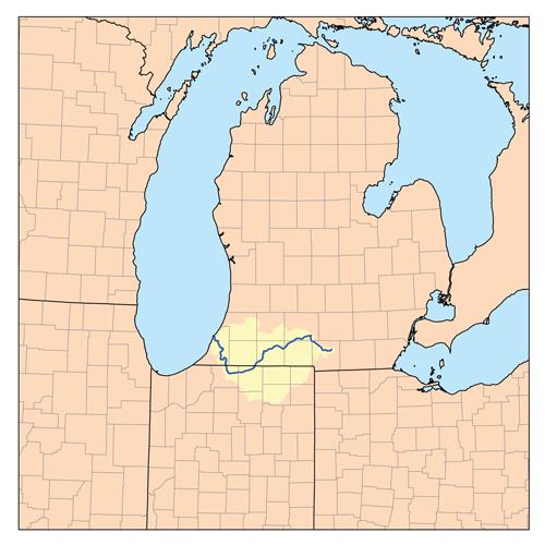
The St. Joseph River Watershed is located in the southwest portion
of the Lower Peninsula of Michigan and northwestern portion of
Indiana. It spans the Michigan-Indiana border and empties into Lake
Michigan at St. Joseph, Michigan. The watershed drains 4,685 square
miles from 15 counties (Berrien, Branch, Calhoun, Cass, Hillsdale,
Kalamazoo, St. Joseph and Van Buren in Michigan and De Kalb,
Elkhart, Kosciusko, Lagrange, Noble, St. Joseph and Steuben in
Indiana). The watershed includes 3,742 river miles and flows
through and near the Kalamazoo-Portage, the Elkhart-Goshen, the
South Bend and the St. Joseph/Benton Harbor metropolitan areas. The
watershed is largely agricultural. More than 50% of the riparian
habitat is agricultural/urban, while 25-50% remains forested.
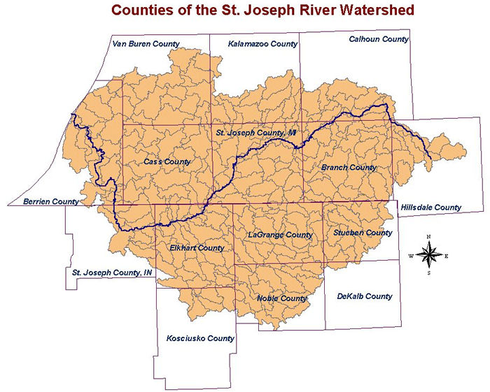
Here is a map of the counties in the St. Joseph watershed (A
watershed is an area of land that drains to a common point)
The posted coordinates above will lead
you to the gage house. This brick structure holds the stream gaging
equipment - typically a gage of some type, a computer, and
communications equipment. A stilling well or a vertical pipe is
located beneath the gage house. Water enters the well through one
or more inlet pipes. The water in the well rises to the same level
as the stream. Recording equipment in the gage house records the
water level in the well. Communications equipment transmits the
data to the
USGS.
Station operated in cooperation with the
French Paper Company
This station is managed by the LANSING FIELD OFFICE
Here is a
(older) picture of the bridge over the St Joseph River. There is a
bike/pedestrian path that runs under the bridge now.

Here is a
file photo of the St. Joseph River looking Downstream of the Gaging
Stagion

Here is a file photo of the St. Joseph
River looking Upstream of the Gaging Stagion

Gaging Station History
In the 1880's, John Wesley Powell, the second director of the USGS,
requested that stream flow be monitored in eight river basins in
the West. It was his idea to measure the flow of streams and rivers
and determine the viability of irrigation systems for this acrid
region. In 1889, the first U.S. stream gaging station was
established on the Rio Grande River in New Mexico. At this station,
standard stream flow measurement procedures were devised.
Today, the USGS operates and maintains more than 85% of the
nation's stream gaging stations. There are over 7,000 stream gaging
stations in the United States, Puerto Rico, and the U.S.
Territories of the Pacific Islands.
The USGS uses it's stream gaging network to provide a free
continuous source of well documented and archived water data. This
data is used by government agencies and private companies to
forecast flooding, design bridges, allocate drinking and irrigation
water, for recreational use, and to manage our valuable surface
water resources.
Real time data for this gage station may be found the internet at:
http://waterdata.usgs.gov/mi/nwis/uv/?site_no=04101500
Addtional Stuff
The St. Joseph River (MI) 2007 RED JEEP Travel Bug -
Click here to view logs
Historical Crests
(1) 15.10 ft on 04/05/1950
(2) 14.97 ft on 03/21/1982
(3) 14.96 ft on 02/25/1985
(4) 14.19 ft on 01/09/2008
(5) 13.78 ft on 05/26/1943
Low Water Records
(1) 4.0 ft on 08/30/1931
(2) 4.5 ft on 07/30/2002
(3) 5.1 ft on 04/28/2003