EARTHCACHE REQUIREMENTS
Each cacher must send his/her own answers BEFORE logging a find. Enjoy the journey (learning adventure) as well as the destination (smiley earned). Remember to take only pictures and leave only footprints. To get credit for this Earthcache, complete the following tasks:
ANSWERS ... SEND ALL ANSWERS VIA MESSAGE
LOG ... INCLUDE THREE ON-SITE VERIFICATION PICTURES ... Valley / Bridge / Creek
1. MESSAGE …. KINZUA VALLEY - a. Name and describe the physiographic province in which the Kinzua Valley/Bridge/Creek are located. ... b. Using topo maps, trace the flow of the Kinzua Creek from Creek (Guffey) to Bridge (Mt. Jewett) to Dam (Warren). Indicate the depth of the valley at each point.
2. MESSAGE …. KINZUA BRIDGE - a. In order to span the valley, how high and how long was the bridge? ... b. The tornado was unexpected due to the topography. Explain.
3. MESSAGE …. KINZUA CREEK - a. When did flooding occur in McKean County PA? ... b. Look at the serene creek flowing before you. Flooding occurred along this creek as a result of a severe thunderstorm in July and massive precipitation with snow melt in January. ..... What is the gauge height at the time of your visit? ..... Describe what you would not have seen in July when the water level was 5'. ..... Describe what you would not have seen in January when the water level was 7'
4. LOG …. Post a picture of you or your signature item at each of the three sites. These pictures are your log signature. No spoiler pics.
OPTIONAL - Please respect the time and effort involved in finding and creating this earthcache by adding A and B to your log.
A. JOURNEY OF THE MIND ... Science explains what we observe. Relate (in your own words) something you found interesting in the reading. This adds to your learning adventure and your log.
B. JOURNEY OF THE HEART ... Art shares our personal experience of what we see. Share something special you found on site, and why it is special to you ... prose / story / poem / picture. This is a memorable addition to your log and will make other hearts smile.
Journeys of Heart and Mind ...
Stories to Touch the Heart and Puzzles to Challenge the Mind / Rainbow Tree Story
THANK YOU LN for travelling and hiking with RT to complete this Earthcache Trail.

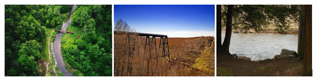
KINZUA VALLEY
The Alleghanian orogeny (geological mountain-forming event) occurred approximately 300 million years ago when the combined continents of Europe and Africa (Gondwana) collided with North America to form the supercontinent of Pangaea. This collision exerted massive stress on what is today the Eastern Seaboard of North America, resulting in a large-scale uplift of the entire region. This event changed Pennsylvania from a depositional basin receiving sediment to an area above sea level that has been eroded continuously ever since. This long period of erosion, which began at least 250 million years ago, has produced the landscape that we see today. Most of the erosion was accomplished during the Mesozoic Era.
The present day landscape of Pennsylvania reflects billions of years of events. Different events took place throughout Pennsylvania, dividing the state into distinct physiographic provinces. The Kinzua Bridge and Dam are located in the Appalachian Plateaus Province. This province is a highland that has been eroded by streams that have created deep valleys and hilly topography. One of these streams is the Kinzua Creek, a tributary of the Allegheny River. The Creek joins the Allegheny Reservoir upstream of the Kinzua Dam on the Allegheny River.
KINZUA BRIDGE
Built in 1882 to span the Kinzua Valley and provide access to Pennsylvania’s vast coal and timber resources, the Kinzua Viaduct was constructed as an alternative to laying an additional eight miles of track over rough terrain. Originally built out of iron, it was the tallest railroad bridge in the world and was advertised as the "Eighth Wonder of the World." In 1900, Octave Chanute designed the new bridge, made of steel, to prevent it from vibrating and swaying in the wind and to accommodate heavier trains. Before its collapse, the Kinzua Bridge ranked as the fourth tallest railway bridge in the United States. The bridge was named to the National Register of Historic Civil Engineering Landmarks in 1977. The Knox and Kane Railroad operated sightseeing trips from Kane through the Allegheny National Forest and over the Kinzua Bridge from 1987 until the bridge was closed in 2002.
On Monday, July 21, 2003, at approximately 3:15 p.m., an F1 tornado (wind speed 73 – 112 mph) struck the side of Kinzua Viaduct. Eleven towers from the center of the bridge were torn from their concrete bases and thrown to the valley floor. The Kinzua Bridge is located in the Kinzua Bridge State Park off of U.S. Route 6 near Mount Jewett, Pennsylvania.
"On July 21, 2003, 3:15 p.m., a tornado registering F1 (wind speed 73-112 mph) on the Fujita scale ripped through Kinzua Bridge State Park and struck the bridge, tearing 11 towers from their concrete bases and throwing them to the valley floor. It took less than 30 seconds for the tornado to destroy a bridge that had stood for over a century, according to an article in the Society for Industrial Archeology newsletter."
In addition, the high winds snapped and uprooted nearby trees, which lay strewn on the valley floor. There were no human deaths or injuries.
“The thunderstorm which spawned the tornado first started producing downburst wind damage 2 miles west of kane. It continued to the northeast for 15 miles...before the tornado touched down 1 mile west of the kinzua viaduct in a wooded area. The tornado continued northeast...producing a damage path 3 1/2 miles long... and about 1/3 mile wide. Winds were estimated at 100 mph...which classifies the tornado as an f1 on the fujita scale. The tornado caused the collapse of the historic kinzua viaduct bridge. Nine of the 20 bridge supports were destroyed...leading to the collapse of the bridge. Thousands of trees were also downed along the path of the tornado. The tornado then lifted up about 2 1/2 miles northeast of the bridge. downburst wind damage continued to about 2 miles north of smethport...where the tornado once again touched down. The tornado continued on a north-northeast path until it lifted again about 1 mile north of farmers valley...near the intersections of routes 46 and 446. Top wind speeds during the second touchdown were estimated at 80 to 90 mph...again classifying the storm as an f1 in intensity. The path of the second touchdown was about 3 miles long...with a width of about 150 yards.”
KINZUA CREEK
Kinzua Creek is a 26.5-mile tributary of the Allegheny River in McKean County, Pennsylvania in the United States.
The upper reaches of the creek pass through Kinzua Bridge State Park, where the creek was spanned by the Kinzua Viaduct until a tornado destroyed the viaduct in 2003.
Kinzua Creek (Native American for "turkey"joins the Allegheny Reservoir 10 miles upstream of the city of Warren, a few miles upstream of the Kinzua Dam on the Allegheny River. The location is also the former location of Kinzua, an unincorporated community that was wiped out as a result of the construction of the Kinzua Dam.
FLASH FLOODING
A flash flood is a rapid flooding of geomorphic low-lying areas: washes, rivers, dry lakes and basins. It may be caused by heavy rain associated with a severe thunderstorm, hurricane, tropical storm, or meltwater from ice or snow flowing over ice sheets or snowfields.
Flash floods are the most dangerous kind of floods, because they combine the destructive power of a flood with incredible speed and unpredictability. Flash floods occur when excessive water fills normally dry creeks or river beds along with currently flowing creeks and rivers, causing rapid rises of water in a short amount of time. They can happen with little or no warning.
There are several areas that are high risk from flash flooding. ... Densely populated areas due to increased runoff from pavement. Storm Drains can be overwhelmed causing death traps in underpasses, underground parking garages, and basements. Areas near rivers due to rapid rise of water. Dam failures can send a sudden destructive wall of water downstream. Ice jams cause water to rapidly build up behind them. Snowmelt from heavy spring rains can also cause flash flooding.
FLOODING - 01/12/2017
Stream data for Station 03011800, Kinzua Creek near Guffey, PA (gage height and discharge) shows the average water level along this creek is 3'. On 01/12/2017 the water level was over 7'. The combination of warm weather, torrential rain, and massive snow melt was responsible for this flash flood causing water to overflow the creek banks.
FLOODING - 07/21/2003
Stream data for Station 03011800, Kinzua Creek near Guffey, PA (gage height and discharge) shows the average water level along this creek is 3'. On 07/21/2003 the water level was over 5'. The combination of a severe thunderstorm and a tornado registering F1 (wind speed 73-112 mph) was responsible for this flash flood causing the significant rise in water levels along the creek.
RESOURCES
The Geological Story of Pennsylvania - DCNR Educational Series 4
Kinzua Bridge Information-History-Reconstruction-Destruction http://en.wikipedia.org/wiki/Kinzua_Bridge
Photo http://commons.wikimedia.org/wiki/Image:Kinzua_Bridge_State_Park_001.jpg
https://weather.com/travel/news/bridge-destroyed-tornado-tourist-attraction-20130723
http://www.wpc.ncep.noaa.gov/research/roth/landcane.html
-Tornadoes are generally formed where there aren't major hills or mountains that can disrupt the flow of the winds generally associated with 2 different fronts. The hills of the Allegheny Plateau generally disrupt the winds necessary to generate a tornado. The tornado that destroyed the bridge was a result of a mesoscale convective system (MCS), a complex of strong thunderstorms, that had formed over an area that included eastern OH, western PA, western NY, and southern Ontario. -Typically, a tornado would have skipped across the valley, causing less damage. In this case, the tornado came right along the valley, with winds from the tornado itself pushing the bridge from one direction, and the inflow of air rushing into the tornado pulling the bridge from the other direction.
http://dcnr.state.pa.us/cs/groups/public/documents/document/dcnr_20032518.pdf
http://www.nssl.noaa.gov/education/svrwx101/floods/
https://nwis.waterdata.usgs.gov/pa/nwis/uv/?cb_00060=on&cb_00065=on&format=gif_default&site_no=03011800&period=&begin_date=2003-07-20&end_date=2003-07-22
https://www.usgs.gov/products/maps/topo-maps
http://www.topozone.com
WATER CACHES
All the water caches are a THANK YOU
to Earth Mother for her life-sustaining waters.
The depth of a soul is not measured by what appears on the surface.