
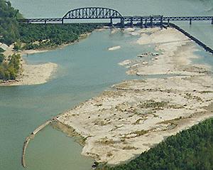
The Lower Wetland
_________________________________________
There are TWO wetland areas at the falls, the LOWER (this one) and the UPPER. Each is designed to provide sustenance for the eco system.
Falls of the Ohio LOWER Wetland
______________________________________________________
 Dating back to the Middle Devonian Period, about 387 million years ago, the fossils found here are the remains of over 600 species of marine animals.
If you could go back in time to the Middle Devonian Period, you would find yourself treading water in a warm, tropical sea. Peering under the crystal blue waters, you would see odd fish swimming around and a variety of colorful corals ringed with stinging tentacles. Some colonies would be just below the wave level. The occasional trilobite would scurry in the coralline debris between the larger colonies. Although the creatures are different, the scene would be similar to swimming in the Bahamas or Australia's Great Barrier Reef today.
______________________________________________________
The fossil beds can be divided into upper and lower layers
 The upper fossil beds are exposed for all but a few weeks each year. You can observe the remains of crinoids stalks, brachiopod shells, lacy bryozoans and a variety of corals in these strata or layers.
In the late summer and early fall there are almost 200 acres of exposed rock layers that can be explored.
The lower fossil beds are often called the coral beds. The abundance of corals is staggering. Over 200 species of corals have been identified in this nine foot-thick layer. Potholes in the limestone rock, formed by swirling glacial pebbles, often trap small fish and other aquatic animals, providing an easy meal for hungry birds.


WHAT IS A WETLAND? "Wetland" is a generic term for all the different kinds of wet habitats where the land is wet for some period of time each year but not necessarily permanently wet.
The wetlands are important feeding and resting areas for migratory birds, such as wood ducks, great blue herons and Canada geese. Grasslands and woodlands found here provide nesting habitat for a variety of birds species including black crowned night herons, kingfishers and osprey.
The water levels change drastically during the year, completely altering the look of the Conservation Area.
At times in the winter and spring, the water is as high as the top of the dam, and hundreds of gulls and terns can be seen, circling above the swirling current. In the summer, when the water level is at its lowest, killdeer and sandpipers scoot around on the rocks, while herons catch fish in the shallows.
River islands, woodlands, wetland, prairie grasslands, rock ledges, mud flats, and river bottom are home to numerous species of plants and animals. The few tree species you see, including willow, cottonwood, sycamore and water maple, are here only because they are able to endure the seasonal extremes of wet and dry, hot and cold.
More than 200 kinds of flowering plants add color to the scenery throughout most of the year. Common mammals include muskrat, beaver, red fox, groundhogs and raccoons.
___________________________________________________________
The federal Clean Water Act defines wetlands as "areas that are inundated or saturated by surface or ground water at a frequency and duration sufficient to support, and that under normal circumstances do support, a prevalence of vegetation typically adapted for life in saturated soil conditions.
Among the most important ecosystems on Earth, the wet ecosystems of bogs, freshwater marshes, prairie potholes, forested swamps, and salt-water estuaries provide critical nesting, rearing, feeding, and stop-over habitat for bird and other wildlife populations in watersheds across the nation.
Wetlands are essential to estuary, river, and watershed health, trapping sediments and cleaning polluted waters, preventing floods, recharging groundwater aquifers, and protecting shorelines.
Wetland health is intimately tied to human health
The Falls of the Ohio is a special area in many respects. Over 265 species of birds and 125 species of fish, along with other wildlife, have been recorded at the Falls.
This changed with the passage by Congress of Public Law 97-137 in December 1981 that designated the area as the Falls of the Ohio National Wildlife Conservation Area (WCA) and placed responsibility for administration of the area with the U S Army Corps of Engineers in consultation with the Department of the Interior.
The law mandates five missions, or purposes of the WCA:
And to demonstrate the educational value of your visit, please email the answers to the following questions:
1. How old are the fossil beds where the wetland is located?
2. How many species of corals are in lower 9-foot thick layer?
3. What are the engineered waterfalls called?
4. How does an aquifer benefit from the wetland?
5. How many large gray spillway gates are in the dam beyond the waterfall where you are standing?
Please email your answers first, then LOG THE FIND. Do not wait on a reply from me. FINDS which do not meet logging requirements will be auto-deleted.