


Educational information:
You will find Quilotoa in the western Cordillera of the Ecuadorian Andes. It is known to be the most western volcano there. The name Caldera originates in the spanish word for cauldron. Calderas are volcanic appearances which can be
found in almost any central volcano. There are two possibilities for a formation: A big eruption detonates the volcano top and leaves only the rump. The remaining caldera in the middle fills up with water. Or: During an eruption the lava is pressed out of the magmatic room. The now empty space can't hold up the above-lying weight of the rocks and part of the vulcano breaks into it; leaving a huge volcanic cauldron. This formation is far more common than the previous mentioned. After a while new lava can flow into the room and bulging the ground another eruption can occur shortly. Calderas are commonly very deep - sometimes up to 1 km, because of this type of formation. They can have a diameter from only a few km up to 100 km, depending on the size of the volcano. Because of their history and the associated volcano the lakes have characteristic differences. In the year 1997 a classification model was developed. The division was made by the physicochemical processes in the water:
 Physicochemical classification scheme for volcanic lakes. Dashed lines indicate tresholds between lake types. [Pasternack, Varkamp; Volcanic lake systematics 1. Physical constraints; Bull Volcanol (1997) 58:528-538; Springer-Verlag, 1997]; no copyright infringement intended Physicochemical classification scheme for volcanic lakes. Dashed lines indicate tresholds between lake types. [Pasternack, Varkamp; Volcanic lake systematics 1. Physical constraints; Bull Volcanol (1997) 58:528-538; Springer-Verlag, 1997]; no copyright infringement intended |
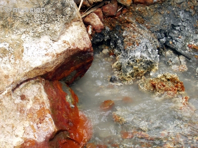
In relation to a few other volcano lakes Cuicocha is not a big caldera. Nonetheless, it shows the characteristics of one. Very steep - almost vertical - declines form the edges of the lake. The lake measures about 3 km in diameter and is up to 260 m deep. The highest crater edge reaches 3914 m. There is a trail around the lake (about 5 hours, good walking shoes, and a good acclimatisation required.) Quilotoa - the name of a legendary princess in this area - has last erupted in the late 13th century and it's lava reached the pacific. There are fumaroles at the bottom of the lake. These are places, where gases from active volcanos emmit into water or air. It is better visible on the east of the caldera where you will be able to see "hot springs".

Degassing volcanoes into a lake can be extremely dangerous as the occurences in 1986 at lake Nyos in Africa showed. The toxic emissions from the volcano don't dissolve in the water and form a gas "bubble" at the bottom of the lake. The amount of a gas that will remain dissolved is influenced by the atmospheric pressure to which the lake is exposed at a given altitude, by meteorological conditions, and also by hydrostatic pressure exerted by the stratum of water overlying a particular depth. The amount of gas that can be held in water by the combined atmospheric and hydrostatic pressures at a particular depth is called the absolute saturation. If this gas bubble is disturbed - for example through an earth slide - the physical balance between the water and the gas is turned over. The convections and turbulences result in the gases being spontaneously released into the air above the water where they can extend quickly. Depending on the amount of toxic gas it can lead to major catastrophies regarding animal life.The lake is now (starting since 2003) under monitoring.
Now on to your tasks here. Apart from a picture of you, your GPS, and the lake which must be included in your log, please do not include the answers. Mail them to me instead.
1. How deep down is the lake from the edge of the crater? (approximately from the beach to the beginning of the path)
2. And how many houses do you find at the bottom of the lake?
3. We built a platform which the natives now use to ship tourists around the lake. Optional request: make a picture of the platform and a picture of the mineral rich stones near the hot springs.
Additional scientific information on the potential dangers of volcano lakes:
The lake Nyos disaster in Cameroon, Africa, which claimed 1800 human victims in August 1986 as well as 3500 livestock in an area of 20 km surrounding the lake. What happened? "A cloud of dense gas erupted from the lake, covering the surrounding area under a deadly blanket several tens of meters thick, for an unknown amount of time. The source of the gas became clear in the aftermath of the disasters, since the normally clear waters of the lakes turned reddish and the lake shores were severely disturbed by waves and strong winds. No one in the path of the cloud managed to escape its lethal effects. Skin discoloration found on some victims were tentatively interpreted as burns, but this diagnosis is still controversial. Witnesses on topographic hights report a loud noise originating from the lake and, in the case of lake Nyos, flashes of light visible over the lake ; both disasters occurred at night, darkness adding to the mystery of these dreadful natural catastrophes. Ten years later, the causes and mechanism of these tragedies are much better understood, albeit not yet completely elucidated." [.../nyos/project/...] In order to prevent similar occurences a global search for similar lakes - both in history and proximity to inhabited areas - has been invoked. These lakes being systematically analyzed and checked for the potential danger.
