This Earthcache will bring you to a location that represents a
river confluence. Park at the coordinates listed above (Hennepin
Canal Parkway; Lock
32). Long pants, sturdy
shoes and mosquito repellent are recommended for this
adventure.

A
body of water that flows down a slope along a channel restricted by
adjacent banks and levees is called a River.
A
River starts at a point called its source, and enters a sea or lake
at its Mouth. Along its length it may be joined by smaller rivers
called tributaries; a river and its tributaries are contained
within a drainage basin called the watershed. The point at which
two or more rivers join, is called the Confluence.
Confluence
, in geography, describes the meeting of two or more bodies of
water. It usually refers to the point where a tributary joins a
more major river, called the mainstem, when that major river is
also the highest order stream in the drainage basin. The term is
also used to describe the meeting of tidal or other non-riverine
bodies of water, such as two canals or a canal and a
lake.
The Mississippi
River is the second longest river in the United States, with
a length of 2,340 miles (3,770 km) from its source in
Lake Itasca in Minnesota to its mouth in the Gulf of
Mexico.
The Mississippi River has the third largest drainage basin (or
catchment) in the world, exceeded in size only by the
watersheds of the Amazon River and Congo River. It drains 41% of
the 48 Continental United States. The basin covers more than
1,245,000 sq mi (3,225,000 km²), including all or parts
of 31 states and two Canadian provinces. The drainage basin empties
into the Gulf of Mexico.
One of those tributaries is the Rock
River.
The Rock River is
approximately 285 miles (459 km) long, in the U.S. states of
Wisconsin and Illinois.
It rises in southeast Wisconsin, in the Theresa Marsh near Theresa,
Wisconsin in northeast Dodge County, Wisconsin approximately 17
miles south of Fond du Lac, Wisconsin. It flows southwest, through
the Horicon National Wildlife Refuge, then meanders southward
draining the area of southeast Wisconsin between the Wisconsin
River and Lake Michigan. It passes through Watertown, collects the
Crawfish River in Jefferson, and receives the Bark River at Fort
Atkinson. In northern Rock County it receives the Yahara River, and
flows southward through Janesville and Beloit into northern
Illinois, where it receives the Pecatonica River 5 miles (8 km)
south of the state
line. It flows south
through Rockford, then southwest across northwestern Illinois,
passing Oregon, Dixon and Rock Falls before joining the Mississippi
at Rock Island.
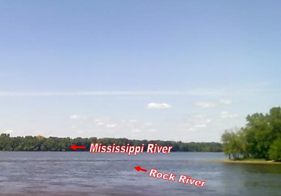
At this spot along the Rock River is also the confluence of the
Hennepin Canal that empties into the Mississippi
river. The Hennepin
canal served as a navigable waterway that was built in order to
lower freight prices. No water routes existed from the Illinois
River to the Mississippi River.
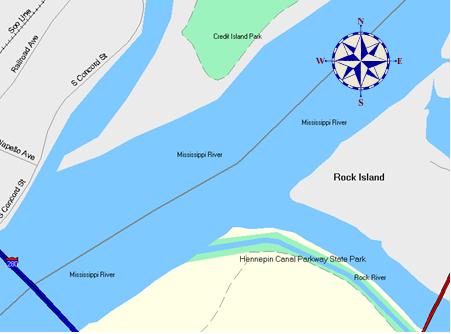
The Hennepin Canal follows a natural low area between Hennepin and
Rock Island. This is actually the ancient channel of the
Mississippi River, which at one time flowed from Rock Island to
Hennepin, and then south through what is now the Illinois River
channel. The Illinois Glaciation, about 200,000 to 125,000 years
before present, blocked the Mississippi River near Rock Island,
diverting it into its modern channel.
Construction on the canal began in 1892 and the first boat went
through in 1907, however, the Corps of Engineers undertook a
widening of the locks on both the Illinois and Mississippi Rivers.
The new locks on those rivers were twenty and forty feet wider than
the canal locks, making them obsolete before their initial
use.
In the 1930s the Hennepin Canal was used primarily for recreational
traffic. The Hennepin Canal, which at one time was known as the
Illinois and Mississippi Canal, was open to boat traffic until 1951
at no cost. These days the Hennepin Canal Parkway is used for
recreational purposes. A trail along the canal allows people to
walk, jog, bike down the canal, or just sit and
fish. In this area the
design of the canal was reconstructed to assist primarily in flood
water control.
To
receive credit for this Earthcache, you must complete the following
2 requirements.
1)
At
N41° 28.886 x W90° 36.980 observe the confluence and note the
distinct line of the Rock River as it enters the Mississippi River.
Now upload a picture of your face and your GPS with the confluence
in the background.
2)
Move
up the shore to N41° 28.869 x W90° 36.914 here you must determine
the flow rate in "Feet per Second" for the Rock River. This may be
done by measuring (bring a tape measure) & marking a distance
along the bank, then tossing in a leaf or twig upriver from your
starting point. With a stop watch, time how long it takes your leaf
to complete your measured distance course. Then calculate that into
"Feet per
Second".
Please
don't post your answer in your log, Email them to me through my
Profile.
This earthcache is placed on Illinois Department of Natural
Resources managed property with permission.
Do not damage, destroy
or harm property, vegetation or wildlife, this is your park help
keep it clean by actively participating in CITO (cache in trash
out) and when you are finished be sure to leave no trace.
Remember it is the visitor’s responsibility to orient themselves
with policies and rules pertaining to this Illinois Department of
Natural Resources managed site.