Orogeny (Greek for "mountain generating") is the process of
natural mountain building.
The Alpine orogeny (sometimes also called Alpide orogeny) is an
orogenic phase in the Tertiary that formed the mountain ranges of
the Alpide belt. These mountains include (from west to east) the
Atlas, the Pyrenees, the Alps, the Dinaric Alps, the Hellenides,
the Balkan, the Taurus, the Caucasus, the Alborz, the Zagros, the
Hindu Kush, the Pamir, the Karakoram, and the Himalayas.
The Alpine orogeny occurred when the continents Africa and India
and the small Cimmerian plate collided (from the south) with
Eurasia in the north. Convergent movements between the tectonic
plates (the Indian plate and the African plate from the south, the
Eurasian plate from the north, and many smaller plates and
microplates) began already in the early Cretaceous, but the major
phases of mountain building began in the Paleocene (The Paleocene
or Palaeocene, "early dawn of the recent", is a geologic epoch that
lasted from 65.5 ± 0.3 Ma to 55.8 ± 0.2 Ma (million years ago).to
Eocene ((55.8 ± 0.2 - 33.9 ± 0.1 Ma). Currently the process still
continues in some of the Alpide mountain ranges.
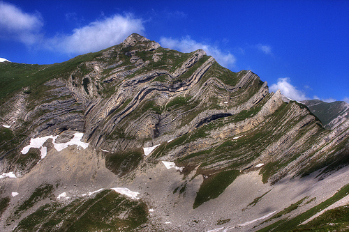
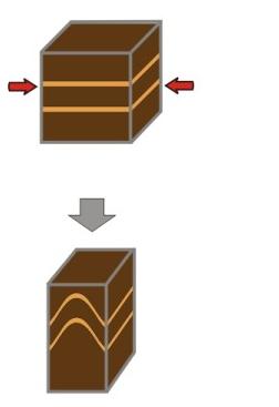
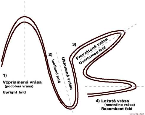
The term fold is used in geology when one or a stack of
originally flat and planar surfaces, such as sedimentary strata,
are bent or curved as a result of plastic (i.e. permanent)
deformation.
Folds in rocks vary in size from microscopic crinkles to
mountain-sized folds. They occur singly as isolated folds and in
extensive fold trains of different sizes, on a variety of scales. A
set of folds distributed on a regional scale constitutes a fold
belt, a common feature of orogenic zones.
In order to log your find, please:
1) send me an answer (via email), how many upright folds you can
see (approx.)
2) upload a picture of Sareni pasovi and you with your GPS unit in
front of it from any place.
3) elevation above sea-level of the location from the place where
you will take your picture.
General geology of Durmitor National Park
Durmitor National Park comprises Mount Durmitor plateau and the
valley formed by the canyon of the River Tara, incorporating three
major geomorphological features: canyons, mountains and plateaux,
ranging in elevation from about 450 - 2,522 m. Because of its
geographical location and range in altitude, the park is under the
influence of both Mediterranean and alpine micro climates which has
resulted in an exceptional range of species.
Geologically, Durmitor and Tara canyons are made up of rocky
massifs of the secondary era (from the lower Triassic to the upper
Cretaceous), tertiary and quaternary eras. The dominant features
are the limestone formations of the middle and upper Triassic, the
upper Jurassic and the upper Cretaceous, especially the so-called
Durmitorean flysch.
Durmitor, this natural link between earth and sky, the Athos of
Montenegro, offers you: 18 lakes, 5 canyons, 27 peaks above 2200
metres, 48 peaks above 2000 metres, 748 sources of potable waters,
forests over 500 years old, 2000 km of marked foot paths and
climbing paths.